
December 21, 2015
New Blog!
I have a new blog called Detroit Urbanism. It's about the way history shapes our maps and built environment in both the city of Detroit and its suburbs. Posts on the new blog will be similar to the last few ones that I have posted on Corktown History, and a whole new site seemed more appropriate home for future articles. Click here to read and enjoy!


October 23, 2015
The Origins of Eight Mile Road

Inspired by the 200th anniversary commemoration of the survey of Michigan and surveyor Joseph Fenicle's April 2015 article on the subject, I've spent the last couple of months researching the field notes of the original surveyors (scans of which are available on SeekingMichigan.org) and the Territorial Papers of the United States in order to understand how our road system and municipal boundaries in Metro Detroit took the shapes that they did. I've been especially interested in the establishment of Eight Mile Road, because this October 24th marks exactly 200 years since the first surveyor's marks were left upon it.
When Michigan was part of the Northwest Territory, the Federal government desired to sell and settle as much land as possible. This necessitated a systematic, economical method of parceling out the land, which we now call the United States Public Land Survey System. Land was divided into townships measuring six miles by six miles, then townships were later subdivided into square mile sections. The first step was establishing vertical and horizontal axes. The east-west axis upon which virtually all land in Michigan (aside from the old French claims and their extensions) was divided is Michigan's Baseline. When land was surveyed and settled, roads tended to be built on township and section lines. Roads have been built on the Baseline throughout the state, and in the Detroit area, 45 miles of it is called Eight Mile Road.
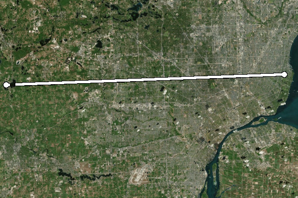
Eight Mile Road.
On April 18, 1815 surveyor Alexander Holmes entered into a contract with Edward Tiffin, Surveyor General of the Northwest Territory, to establish the Baseline. He was also to survey a portion of the 96 townships that had been set aside to be divided and used as payment to soldiers and officers who had served in the Revolutionary War. Holmes received permission to give half the contract to his surveyor brother, Samuel. The contract stipulated a payment of $2.50 per mile of township and section line surveyed, and $3.00 per mile of baseline surveyed. Each surveyor had to pay his own crew out of these funds. They measured their path with a Gunter's chain, cut down trees that were in their line of sight, and planted posts every half mile along their path.
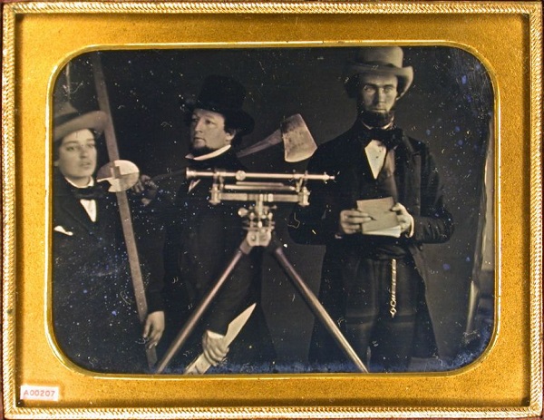
Surveyors and their tools, circa 1850. (Source.)
Alexander Holmes had attempted to begin running the Baseline in May of 1815, but was driven back to Detroit by Indians who disagreed over the description of boundaries given in the 1807 Treaty of Detroit, which granted most of southeast Michigan to the U.S. government. It's not known whether Holmes actually reached the Baseline then, and if so, how much work he accomplished, or if any of that work might coincide with today's Eight Mile Road.
Why There?
Why was the Baseline drawn where it was? Various proposals were considered before surveying began. Surveyor General of the United States Josiah Meigs suggested a baseline "beginning at Detroit, running from thence ... due west" in March of 1815. But Edward Tiffin proposed a scheme where the Baseline would be run north of Detroit, and Meigs approved. Tiffin's contract with Holmes simply instructs him to run "a true base line due West from a point above Detroit". For a long time I believed that the location of Michigan's Baseline was tied with the Point of Beginning in Woodward's plan of Detroit--Ford Road, which coincides with a section line in the survey system, appears to almost line up with Michigan Avenue, which is an arterial road in Woodward's plan. This appears to be only a coincidence.
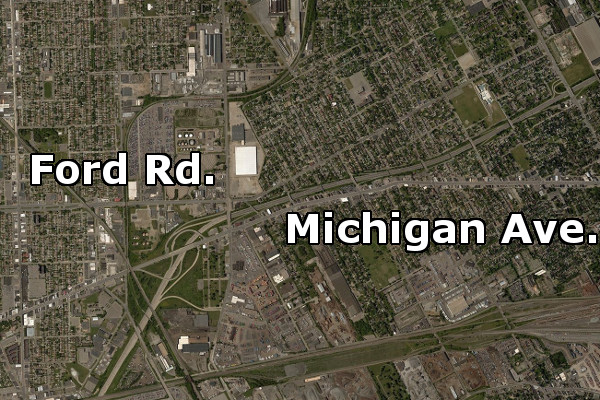
Ford Road and Michigan Avenue are misaligned by only 300 feet, but
the Woodward Plan probably did not influence the survey of Michigan.
The real reason had to do with the 96 townships of military bounty land mentioned earlier. This area was to measure eight townships wide by twelve townships long. The western border was to rest on the Michigan Meridian, the north-south axis of the survey. The Baseline was to run directly through it, putting 48 townships north of the Baseline and 48 townships south of it. The surveyors needed to ensure that this land in no way interfered with Ohio's land claims. Ohio's northern border had not yet been surveyed, but it was supposed to terminate at the Maumee River Bay, possibly as far as the northernmost cape within the bay, well within present-day Erie Township, Michigan.
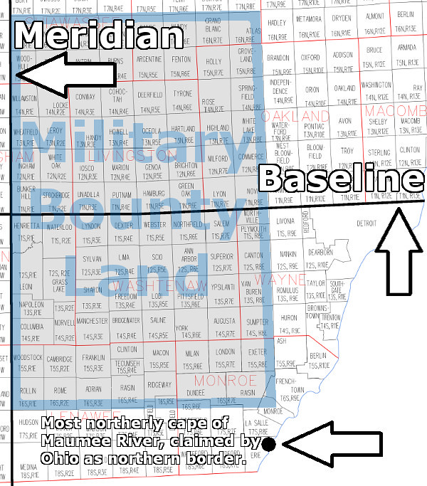
Surveyor Benjamin Hough was contracted to survey the Michigan Meridian, which coincided with the western border of land ceded by Native American tribes in the 1807 Treaty of Detroit. According to the treaty, the border began at Fort Defiance, Ohio and ran due north. Hough first traveled to Maumee Bay, and on May 27, 1815 observed the position of the sun at noon and calculated his latitude to be 41°47'07" North. (He made this observation at the northernmost cape in Maumee Bay, apparently as a means of extreme caution. Ohio's actual border, surveyed the following year, began 3.7 south of this point.) Hough used this data to determine how far north the military bounty land should lie, and then rounded this figure so that there would be a whole number of townships between Fort Defiance and the military reserve. Hough calculated that Fort Defiance should be at the southwest corner of the 13th township south of the Baseline, and that the military land would begin seven townships north of there.
Thirteen townships measuring six miles on a side is 78 miles. Michigan's Baseline and Eight Mile Road exist where they do because the center of the military bounty land needed to be 78 miles north of Fort Defiance in order for that land to lie completely outside of the State of Ohio.
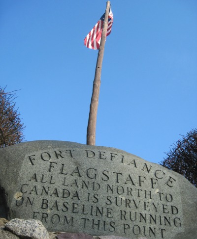
A monument at Fort Defiance marks the beginning of the Michigan Meridian.
The Survey Begins
Alexander Holmes teamed up with Benjamin Hough, who began his work at Fort Defiance on September 29, 1815. The two apparently traveled north together and planned to split up once they reached the calculated position of the Baseline. Instead, they were blocked by the impassable and flooded Grand River in what is now Leoni Township. Rather than meticulously measuring a path around the flooded area using a surveying technique called "meandering," Holmes backtracked slightly and began surveying east on a line twelve miles south of and parallel to the Baseline.
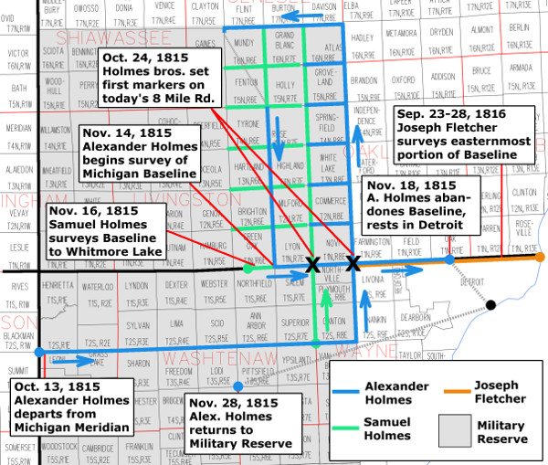
In the vicinity of Detroit, Alexander Holmes met up with his brother, Samuel, who was waiting for him with additional provisions and assistants as planned. On October 23rd 1815 they set north simultaneously from the east-west line that Alexander had surveyed. Alexander's team worked north on what is now Haggerty Road, which was originally intended to be the western border of the 96 military reserve townships. Samuel's team surveyed north on what is now Napier Road.
The field notes taken by both teams indicate that they reached the Baseline and set their marks on October 24th. The spot where Alexander Holmes drove a post into the ground is preserved by a modern surveyor's marker, protected by a cast iron cover and marked with a white X in the median on Eight Mile Road just west of I-275. It still denotes the legal corner between present-day Farmington Hills, Novi, Northville Township and Livonia. Everyone interested in the history of Farmington knows that Arthur Power was the first white settler in the township, but the surveyors came first--clearing a path through the forest and leaving their marks almost a decade before Arthur Power arrived.
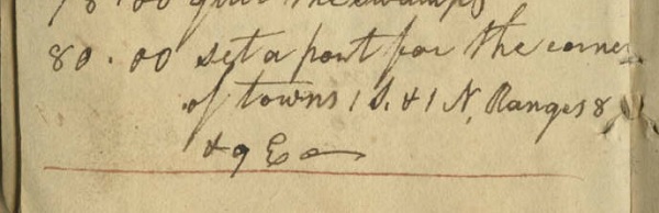
Excerpt from Alexander Holmes' field notes when he
planted a post at today's Eight Mile Road and Haggerty.
Image courtesy of the Archives of Michigan.
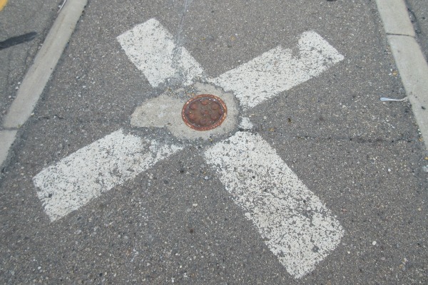
The exact spot where surveyor Alexander Holmes set his
first marker on Michigan's Baseline on October 24, 1815.
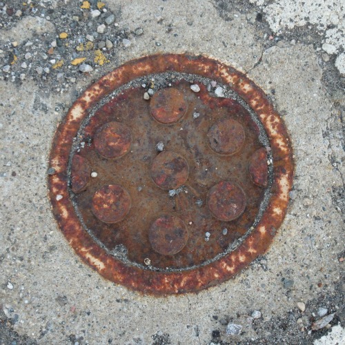
This cast iron cover protects a modern surveyor's mark, set
over the spot first marked by Alexander Holmes 200 years ago.
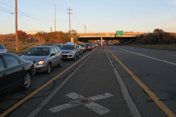
"Mommy, why is that man taking pictures of the street?"
Six miles west of Alexander's mark, the post Samuel planted on the same day is similarly preserved, and serves as the corner of Novi, Lyon Township, Salem Township, and Northville Township. Who is to say which brother arrived at the Baseline first?
After several weeks of hacking township borders through swamps and forests, Alexander's team again reached the Baseline, on November 14th. There they set the third post on the line, which is now the southwest corner of the City of South Lyon. From there, Alexander began to survey the Baseline toward the east. Although other teams may have surveyed portions of the Baseline in Jackson County, this is the first surveyor's line drawn on the Baseline where it coincides with Eight Mile Road. Well, almost... After reaching Samuel's post at today's Napier Road, he found that he had reached it 594 feet too soon, and had to resurvey that six mile segment from east to west. (Townships were supposed to be surveyed so that any deficiencies would lie on their west and north borders--this line was resurveyed so that the deficient mile would appear on the western edge of Lyon Township.)
Samuel Holmes reached the South Lyon post and then began surveying the Baseline west on November 16th. After a few miles he ran into Whitmore Lake. Rather than meander around the 677-acre lake, he left the Baseline to continue dividing townships south of the area.
Meanwhile, Alexander Holmes continued east along the Baseline, all the way to what is now the Ferndale-Detroit border. After setting a quarter section post one half mile east of today's Livernois Ave. on November 18th, he wrote in his field notes: "We have been wading in ice water for three days and are completely worn out -- quit and went to Detroit which is situate [sic] a little E. of South and about nine miles distant."
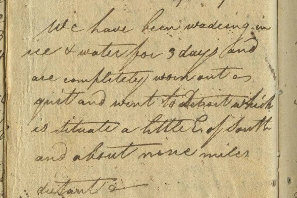
Excerpt from the field notes of Alexander Holmes, November 18, 1815.
Image courtesy of the Archives of Michigan.

The team rested in Detroit, hoping that the swamps would freeze enough to allow the surveyors and their horses to walk across their surface rather than slush through them. Alexander Holmes returned to the field nine days later, but did not continue the Baseline. Samuel Holmes, however, did reach the western side of Whitmore Lake in December. He surveyed the 1.3 miles of the Baseline on the other side of the lake, including the point that is considered the western terminus of Eight Mile Road. He continued the line six more miles west, but the field notes are crossed out and his work was evidently redone.
Finishing the Job
The remainder of the Baseline that coincides with Eight Mile Road was surveyed the following year by Joseph Fletcher. He began at the post established by Alexander Holmes at today's Haggerty Road on September 23rd, 1816. From there he headed east, resurveying Holmes' work. Fletcher reached Lake St. Clair five days later. In a letter to Edward Tiffin, he wrote:
"I ... proceeded agreeable to my instructions to the base line, the line being very badly blazed. I was obliged to trace it with the compass on examination found I was not authorised by my instructions to vary from the line already run by Mr. Holmes only in measurement. I then proceeded with the line to the western border of lake St. Clair....
"... the lines vary very much from the field notes and plats--and the lines being indifferently blazed--renders it one of the most disagreeablest jobs I ever was engaged in..."

Eight Mile Road's eastern terminus in St. Clair Shores,
about one and a half miles west of Lake St. Clair.
Fletcher complained that the Baseline in this area runs slightly to the northeast by 2°40'. Here is the reason why that is. Back at Fort Defiance, Benjamin Hough carefully observed the North Star in order to calculate the difference between true north and magnetic north. He found the deviation to be 4°39' east. Following this deviation worked very well in the beginning, but that observation became less accurate the farther the surveyors moved from Fort Defiance. Additional astronomical observations should have been made to update the proper deviation from magnetic north, but the surveyors were suffering many hardships and running out of time. Alexander Holmes simply pressed on to get the job done. After Fletcher finished the eastern portion of the Baseline following to Holmes' path, he realized that running range lines according to true north would result in rhombus-shaped townships and sections. In order to maintain squareness and consistency, he ran his lines perpendicular to the Baseline. This is why our major roads and municipal borders in Metro Detroit all appear slightly skewed on a map aligned to true north.
Despite these inaccuracies, the imposition of a rectangular grid on the forested surface of a spheroid planet two centuries ago is an impressive human achievement.
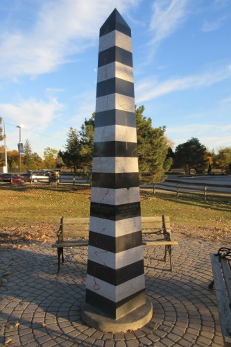
This obelisk in Farmington Hills close to Eight Mile Road is part
of sculptor David Barr's Coasting the Baseline series.
Barr passed away on August 28, 2015.
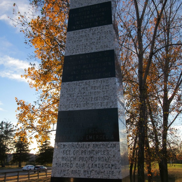
"Surveyors exhibited courage, determination, integrity and ingenuity in the heroic feat of measuring Michigan from 1815-1853. Their work resulted in global implementation of innovative methods of land measurement and ownership. The history of the surveying of the Base Line reveals the collision of four contrasting concepts of property: Native American, European Aristocratic, Colonial American, and Jeffersonian. From this emerged a new uniquely American set of principles which profoundly shaped our landscape, laws, and way of life."
April 1, 2015
Moving On
I became a Corktown resident ten years ago today. My first address in the neighborhood was a large Victorian house that had been divided into apartments. Since then I have had three other Corktown addresses--on Wabash St., Ash St., and Bagley Ave. Most of the years of my adult life have been spent here.

1368 Pine Street, my first Corktown residence.
Today I am sad to announce that I will be moving away. No, this isn't world's lamest history-blog-related April Fool's Day prank. Although I've never had a reason to discuss personal information here, I think I do owe an explanation for my leaving. It has nothing to do with Detroit's infamous quality of life issues (crime, insurance costs, or worse). I think I came well equipped to handle those.
My problem is that I'm extremely sensitive to noise, especially low frequencies. Corktown is not only an urban neighborhood at the center of a major metropolitan region, but it's a nighttime entertainment district. Noises don't necessarily have to be at a high decibel level in order to cause severe discomfort for me. Sometimes when I am disturbed by a band playing in a bar close to my house, my girlfriend will barely be able to hear the music at all. I've discussed noise with my neighbors, but they see it as just an inconvenience and not a cause of extreme discomfort or psychological stress. Now, the last thing the internet needs is another blogger diagnosing himself with some sort of medical issue via Google--but having said that--there is an unmistakable overlap between my experience and the symptoms of conditions like hyperacusis, misophonia, and selective sound sensitivity syndrome.
So, Corktown, "it's not you, it's me." I don't want to be the prude who goes around the neighborhood wagging his finger at people and telling them to turn their music down. I think it will be wisest for me to peacefully bow out.
It will be a few more weeks until the actual move, but in a lot of ways I'm regretting it already. I've never lived anywhere else where I knew as many of my neighbors as I do here. I've never carved out a niche for myself or felt more productive and useful as I do when practicing my abilities as a researcher of the history of Detroit's oldest neighborhood. And it goes without saying that Corktown's architecture and walkability will be very sorely missed.
After carefully considering other communities in southeast Michigan, my girlfriend and I ultimately chose a place in Farmington. As my neighbor Jon asked, "Farmington?!? Why!?!" Our basic criteria were that the new house had to 1.) be old (pre-WWII), 2.) be affordable, and 3.) located in a city with a walkable downtown, but 4.) not in an area that is a major nighttime party destination. We found a cottage built in 1935 on a wooded acre in Farmington Hills just one mile from downtown Farmington. There is one neighbor on the north side, a daycare to the south, and undeveloped forest to the east. We got a good deal because the house needed a total rehab--the asbestos-wrapped ducts needed to be removed, and it needed a new roof, furnace, plumbing and electrical systems. The kitchen and bathroom have been gutted completely, and I've been working at the house every weekend for five months--plus using up all of my vacation time at work--to get the job done on time. As I write this, the rough building, plumbing and electrical work has been approved and the drywall is just barely up (and scheduled to be finished this weekend). The bathroom and kitchen should be functional just in the nick of time for our scheduled move-in. In the summer I will remove the aluminum siding and repaint the original cedar lap siding beneath.

The Harold and Adaline Jamieson Cottage, built in 1935.
Farmington Hills, Michigan.
In addition to the house itself being a good find, there is a lot to like about Farmington/Farmington Hills. They appear to have a very active local history community and take a lot of pride in their historic architecture. The City of Farmington's Vision Plan is right-on as far as urbanism and walkability are concerned. And Farmington is where architects Wells D. Butterfield and his daughter, Emily Helen Butterfield--the designers of a previous home of mine settled and continued to work when they left Detroit.
This isn't the final entry for this blog--I have a few more research ideas that I'd like to work out. There is no need for me to start a blog about Farmington's history, which is already well-researched--but I do have a vague idea for a new website that combines history, maps, and architecture. The concept still needs some work.
One final note--sometimes a few local blogs will highlight anecdotes of Detroit city residents expressing hostility to newcomers. Maybe that happens occasionally. But my own experience of moving into the city after only having spent a small part of my childhood here has been overwhelmingly positive. The lifelong Detroiters I've met in Corktown and elsewhere are especially tolerant, friendly, and agreeable people. If you move here, I believe you will feel very welcome.
1368 Pine Street, my first Corktown residence.
Today I am sad to announce that I will be moving away. No, this isn't world's lamest history-blog-related April Fool's Day prank. Although I've never had a reason to discuss personal information here, I think I do owe an explanation for my leaving. It has nothing to do with Detroit's infamous quality of life issues (crime, insurance costs, or worse). I think I came well equipped to handle those.
My problem is that I'm extremely sensitive to noise, especially low frequencies. Corktown is not only an urban neighborhood at the center of a major metropolitan region, but it's a nighttime entertainment district. Noises don't necessarily have to be at a high decibel level in order to cause severe discomfort for me. Sometimes when I am disturbed by a band playing in a bar close to my house, my girlfriend will barely be able to hear the music at all. I've discussed noise with my neighbors, but they see it as just an inconvenience and not a cause of extreme discomfort or psychological stress. Now, the last thing the internet needs is another blogger diagnosing himself with some sort of medical issue via Google--but having said that--there is an unmistakable overlap between my experience and the symptoms of conditions like hyperacusis, misophonia, and selective sound sensitivity syndrome.
So, Corktown, "it's not you, it's me." I don't want to be the prude who goes around the neighborhood wagging his finger at people and telling them to turn their music down. I think it will be wisest for me to peacefully bow out.
It will be a few more weeks until the actual move, but in a lot of ways I'm regretting it already. I've never lived anywhere else where I knew as many of my neighbors as I do here. I've never carved out a niche for myself or felt more productive and useful as I do when practicing my abilities as a researcher of the history of Detroit's oldest neighborhood. And it goes without saying that Corktown's architecture and walkability will be very sorely missed.
After carefully considering other communities in southeast Michigan, my girlfriend and I ultimately chose a place in Farmington. As my neighbor Jon asked, "Farmington?!? Why!?!" Our basic criteria were that the new house had to 1.) be old (pre-WWII), 2.) be affordable, and 3.) located in a city with a walkable downtown, but 4.) not in an area that is a major nighttime party destination. We found a cottage built in 1935 on a wooded acre in Farmington Hills just one mile from downtown Farmington. There is one neighbor on the north side, a daycare to the south, and undeveloped forest to the east. We got a good deal because the house needed a total rehab--the asbestos-wrapped ducts needed to be removed, and it needed a new roof, furnace, plumbing and electrical systems. The kitchen and bathroom have been gutted completely, and I've been working at the house every weekend for five months--plus using up all of my vacation time at work--to get the job done on time. As I write this, the rough building, plumbing and electrical work has been approved and the drywall is just barely up (and scheduled to be finished this weekend). The bathroom and kitchen should be functional just in the nick of time for our scheduled move-in. In the summer I will remove the aluminum siding and repaint the original cedar lap siding beneath.
The Harold and Adaline Jamieson Cottage, built in 1935.
Farmington Hills, Michigan.
In addition to the house itself being a good find, there is a lot to like about Farmington/Farmington Hills. They appear to have a very active local history community and take a lot of pride in their historic architecture. The City of Farmington's Vision Plan is right-on as far as urbanism and walkability are concerned. And Farmington is where architects Wells D. Butterfield and his daughter, Emily Helen Butterfield--the designers of a previous home of mine settled and continued to work when they left Detroit.
This isn't the final entry for this blog--I have a few more research ideas that I'd like to work out. There is no need for me to start a blog about Farmington's history, which is already well-researched--but I do have a vague idea for a new website that combines history, maps, and architecture. The concept still needs some work.
One final note--sometimes a few local blogs will highlight anecdotes of Detroit city residents expressing hostility to newcomers. Maybe that happens occasionally. But my own experience of moving into the city after only having spent a small part of my childhood here has been overwhelmingly positive. The lifelong Detroiters I've met in Corktown and elsewhere are especially tolerant, friendly, and agreeable people. If you move here, I believe you will feel very welcome.
October 20, 2014
Indian Trails and Woodward's Plan
Last Thursday, michiganradio.org published a story in answer to the question, "8 Mile Road is eight miles from where?" I love everything about the early urban planning history of Detroit and I was glad to see the subject come up in the local media. The essential answer given (that 8 Mile Road is eight miles from Campus Martius in downtown Detroit) is correct, but there were some inaccuracies in the piece that deserve correction.
The story claims that the spoke-wheel layout of downtown Detroit is not the work of Augustus Woodward--who of course drew up a new plan for the city after it burned in 1805--but it was based on the Indian trails that converged in Campus Martius. "When Detroit was settled, Campus Martius was deemed the center of town because it was where all of these main roads came together," the author writes.
Campus Martius was not at all the center of early Detroit. The location of the original French fort was chosen for its defendability and convenience, not because of any confluence of Indian trails. There was not yet a settlement (European or Native American) for these trails to converge upon. Old Detroit stood at the water's edge near what is now the intersection of Jefferson Avenue and Shelby Street. The fort gradually grew until it reached about the size of four modern city blocks. In 1779, the British built a more modern military fort north of the old French town at what is now the intersection of Fort and Shelby Streets. Below is a map of Detroit from around 1796 (when the United States took over) with the city's modern street grid superimposed over it. Campus Martius, on the upper right hand corner, was well outside of the settlement.

Even as the city rebuilt following the 1805 fire, some Detroiters scoffed at the idea that the town would ever expand far enough to encompass what is now Campus Martius. John Gentle petitioned President Thomas Jefferson directly, complaining about taxes being wasted on "digging wells and erecting pumps ... near half a mile behind the town of Detroit, where in our opinion no town will ever exist." In the new town's early days, the greatest concentration of buildings was south of Jefferson Avenue, roughly where Hart Plaza is today. As late as 1819, the main streets of the town were Jefferson, Woodbridge, and Atwater, and the north-south streets barely even reached Campus Martius.
The conventional wisdom that the spoke-wheel street pattern of Detroit came from Augustus Woodward's ideas is actually correct. Here is one engraving of his magnificent plan:
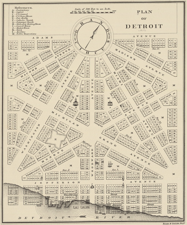
The English-built fort, just west of Campus Martius, gives us a reference point for understanding its relation to the old settlement. Why did Woodward place Campus Martius, the center of the new city, where he did? It was simply because it was in the middle of the public grounds. Under French rule, none of the land immediately outside of the fort was ever granted to private individuals. It was surrounded by a large common area which was flanked on either side by privately owned ribbon farms.

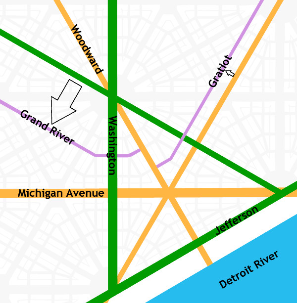
How do we know that our spoke-wheel roads are based on Woodward's plan? Let's look at how the plan is organized. Its foundation is a 4,000-foot equilateral triangle, outlined in green below. The triangle is bisected three times with streets (outlined in orange) that all intersect at Campus Martius.

Woodward's plan, if it was allowed to be fully carried out, would look like this, if the map is rotated so that due north is straight up:

The scheme viewed from farther out:

There are differences between this plan and the roads we have today, which I will get to in a moment. The point here is that these roads are all based on the bisected equilateral triangle, yielding avenues separated from one another by 30° angles. Indian trails followed the land, sticking to high ground, avoiding obstacles, crossing streams at their narrowest point. The roads built by the United States government cut straight, rigid paths through the land. Indian trails were unplanned, unmapped, and developed emergently under the feet of travelers following the most convenient route to a destination. They might branch out and reconnect, and did not have pinpoint beginnings and endings. Indian trails and Woodward's plan are two very different systems with very different origins.
How do today's roads diverge from Woodward's plan? First, Washington Avenue never continued north of Grand Circus Park. Second, Gratiot Avenue was built one block north of where it "should" have been because the owner of the Brush Farm had an orchard that was in the way. And third, Grand River Avenue didn't extend through Grand Circus Park from Miami Avenue (which is now named Broadway) but it is two blocks south of that. This is probably because Grand Circus Park was a swamp when construction began on Grand River Avenue in 1832.
Having said all that, didn't some of our roads begin as Indian trails? Definitely. US-24 between Detroit and Toledo mostly lies upon an old segment of the Maumee Trail, expanded and improved upon by the U.S. government in 1814. Much of the St. Joseph Trail is preserved by various rural highways. Shiawassee Road in Farmington coincides with an Indian trail that appears in an 1817 survey:

If I do make one concession to the idea that Woodward's plan is connected to the Indian trails, it would be to say that Woodward Avenue did replace the old Saginaw Trail between Detroit and Pontiac. This path appears on an 1817 survey of Royal Oak Township (which was once a six-mile-by-six-mile square bound by 8 Mile Rd., Dequindre, 14 Mile Rd., and Greenfield). Here is that path (which splits into two and then comes together again) superimposed over a modern map of the area:

When you are driving on Woodward Avenue in Detroit, you aren't exactly retracing the steps of the Native Americans and pioneers of two centuries ago, but you are at least headed in approximately the same direction.
It is claimed that Michigan Avenue (US-12) follows the Sauk Trail. This is true for much of US-12 in the middle of the state, but it is not true of Michigan Avenue within today's Detroit city limits. Michigan Avenue begins at Campus Martius and heads in a straight line due west for almost five miles before turning south to eventually meet the old Indian path many miles later. Most likely, it appears that eastbound travelers on the Sauk Trail came to Detroit by first arriving at the River Raisin, following it down to the Detroit River, and then following the shoreline upstream to Detroit.
Some say that Gratiot Avenue follows the old Moravian Road, but that is not correct. The Moravian Road actually began at Connor's Creek, 4.5 miles east of Campus Martius. It curved to the northeast and ended at the Moravians' settlement in what is now Harrison Township. Gratiot Avenue begins in downtown Detroit, runs in a straight line for fifteen miles before its first curve, and terminates in Port Huron. These roads head in roughly the same direction, but one is not based on the other.
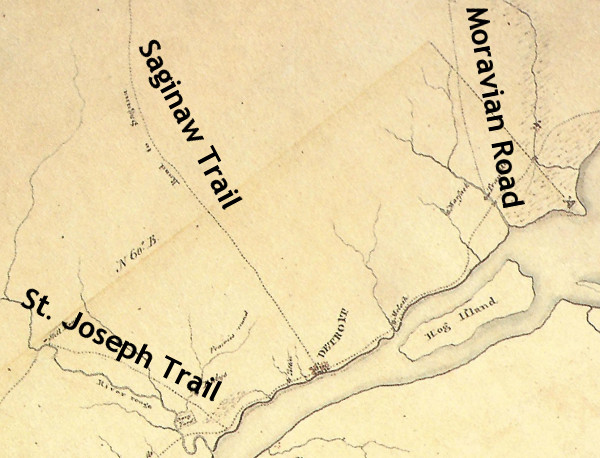
Detroit and vicinity circa 1797.
Source: King, Robert after Patrick McNiff. A Rough Sketch of part of Wayne County Territory of theUnited States North-west of the River Ohio [map]. In: Dunnigan, Brian L. Frontier Metropolis: Picturing Early Detroit, 1701-1838. Detroit: Wayne State University Press, 2001, p. 106.
Grand River Avenue has a similar story to Michigan Avenue. It is often claimed to be an Indian trail, but that is only true for some portions well within the interior of the state. It began as a road to Howell before being extended to the west side of Michigan. Perhaps it is confused with the Shiawassee trail, which intersected Grand River Avenue in downtown Farmington. This trail appears to begin well west of the settlement at Detroit, and heads north to Saginaw after passing through Farmington.

Detail from an 1825 survey of Michigan, showing the Shiawassee Trail. (Source.)
There is SO MUCH MORE that I wish I could write about. I didn't even mention the Woodward plan's Point of Origin, which you can see in Campus Martius Park; or the amazing Public Land Survey System; or the beautiful connection between the two, or their relationship to 8 Mile Road (which, by the way, has nothing to do with the Wisconsin/Illinois border as the article also claims).
Thank you, Michigan Radio, for bringing up my favorite subject! Honestly, this has made me want to start a whole new blog just about the urban planning history of Detroit.
The story claims that the spoke-wheel layout of downtown Detroit is not the work of Augustus Woodward--who of course drew up a new plan for the city after it burned in 1805--but it was based on the Indian trails that converged in Campus Martius. "When Detroit was settled, Campus Martius was deemed the center of town because it was where all of these main roads came together," the author writes.
Campus Martius was not at all the center of early Detroit. The location of the original French fort was chosen for its defendability and convenience, not because of any confluence of Indian trails. There was not yet a settlement (European or Native American) for these trails to converge upon. Old Detroit stood at the water's edge near what is now the intersection of Jefferson Avenue and Shelby Street. The fort gradually grew until it reached about the size of four modern city blocks. In 1779, the British built a more modern military fort north of the old French town at what is now the intersection of Fort and Shelby Streets. Below is a map of Detroit from around 1796 (when the United States took over) with the city's modern street grid superimposed over it. Campus Martius, on the upper right hand corner, was well outside of the settlement.
Even as the city rebuilt following the 1805 fire, some Detroiters scoffed at the idea that the town would ever expand far enough to encompass what is now Campus Martius. John Gentle petitioned President Thomas Jefferson directly, complaining about taxes being wasted on "digging wells and erecting pumps ... near half a mile behind the town of Detroit, where in our opinion no town will ever exist." In the new town's early days, the greatest concentration of buildings was south of Jefferson Avenue, roughly where Hart Plaza is today. As late as 1819, the main streets of the town were Jefferson, Woodbridge, and Atwater, and the north-south streets barely even reached Campus Martius.
The conventional wisdom that the spoke-wheel street pattern of Detroit came from Augustus Woodward's ideas is actually correct. Here is one engraving of his magnificent plan:
The English-built fort, just west of Campus Martius, gives us a reference point for understanding its relation to the old settlement. Why did Woodward place Campus Martius, the center of the new city, where he did? It was simply because it was in the middle of the public grounds. Under French rule, none of the land immediately outside of the fort was ever granted to private individuals. It was surrounded by a large common area which was flanked on either side by privately owned ribbon farms.
How do we know that our spoke-wheel roads are based on Woodward's plan? Let's look at how the plan is organized. Its foundation is a 4,000-foot equilateral triangle, outlined in green below. The triangle is bisected three times with streets (outlined in orange) that all intersect at Campus Martius.
Woodward's plan, if it was allowed to be fully carried out, would look like this, if the map is rotated so that due north is straight up:
The scheme viewed from farther out:
There are differences between this plan and the roads we have today, which I will get to in a moment. The point here is that these roads are all based on the bisected equilateral triangle, yielding avenues separated from one another by 30° angles. Indian trails followed the land, sticking to high ground, avoiding obstacles, crossing streams at their narrowest point. The roads built by the United States government cut straight, rigid paths through the land. Indian trails were unplanned, unmapped, and developed emergently under the feet of travelers following the most convenient route to a destination. They might branch out and reconnect, and did not have pinpoint beginnings and endings. Indian trails and Woodward's plan are two very different systems with very different origins.
How do today's roads diverge from Woodward's plan? First, Washington Avenue never continued north of Grand Circus Park. Second, Gratiot Avenue was built one block north of where it "should" have been because the owner of the Brush Farm had an orchard that was in the way. And third, Grand River Avenue didn't extend through Grand Circus Park from Miami Avenue (which is now named Broadway) but it is two blocks south of that. This is probably because Grand Circus Park was a swamp when construction began on Grand River Avenue in 1832.
Having said all that, didn't some of our roads begin as Indian trails? Definitely. US-24 between Detroit and Toledo mostly lies upon an old segment of the Maumee Trail, expanded and improved upon by the U.S. government in 1814. Much of the St. Joseph Trail is preserved by various rural highways. Shiawassee Road in Farmington coincides with an Indian trail that appears in an 1817 survey:
If I do make one concession to the idea that Woodward's plan is connected to the Indian trails, it would be to say that Woodward Avenue did replace the old Saginaw Trail between Detroit and Pontiac. This path appears on an 1817 survey of Royal Oak Township (which was once a six-mile-by-six-mile square bound by 8 Mile Rd., Dequindre, 14 Mile Rd., and Greenfield). Here is that path (which splits into two and then comes together again) superimposed over a modern map of the area:
When you are driving on Woodward Avenue in Detroit, you aren't exactly retracing the steps of the Native Americans and pioneers of two centuries ago, but you are at least headed in approximately the same direction.
It is claimed that Michigan Avenue (US-12) follows the Sauk Trail. This is true for much of US-12 in the middle of the state, but it is not true of Michigan Avenue within today's Detroit city limits. Michigan Avenue begins at Campus Martius and heads in a straight line due west for almost five miles before turning south to eventually meet the old Indian path many miles later. Most likely, it appears that eastbound travelers on the Sauk Trail came to Detroit by first arriving at the River Raisin, following it down to the Detroit River, and then following the shoreline upstream to Detroit.
Some say that Gratiot Avenue follows the old Moravian Road, but that is not correct. The Moravian Road actually began at Connor's Creek, 4.5 miles east of Campus Martius. It curved to the northeast and ended at the Moravians' settlement in what is now Harrison Township. Gratiot Avenue begins in downtown Detroit, runs in a straight line for fifteen miles before its first curve, and terminates in Port Huron. These roads head in roughly the same direction, but one is not based on the other.
Detroit and vicinity circa 1797.
Source: King, Robert after Patrick McNiff. A Rough Sketch of part of Wayne County Territory of theUnited States North-west of the River Ohio [map]. In: Dunnigan, Brian L. Frontier Metropolis: Picturing Early Detroit, 1701-1838. Detroit: Wayne State University Press, 2001, p. 106.
Grand River Avenue has a similar story to Michigan Avenue. It is often claimed to be an Indian trail, but that is only true for some portions well within the interior of the state. It began as a road to Howell before being extended to the west side of Michigan. Perhaps it is confused with the Shiawassee trail, which intersected Grand River Avenue in downtown Farmington. This trail appears to begin well west of the settlement at Detroit, and heads north to Saginaw after passing through Farmington.
Detail from an 1825 survey of Michigan, showing the Shiawassee Trail. (Source.)
There is SO MUCH MORE that I wish I could write about. I didn't even mention the Woodward plan's Point of Origin, which you can see in Campus Martius Park; or the amazing Public Land Survey System; or the beautiful connection between the two, or their relationship to 8 Mile Road (which, by the way, has nothing to do with the Wisconsin/Illinois border as the article also claims).
Thank you, Michigan Radio, for bringing up my favorite subject! Honestly, this has made me want to start a whole new blog just about the urban planning history of Detroit.
October 13, 2014
Sam's Loan Office -- aka "Gold Cash Gold"
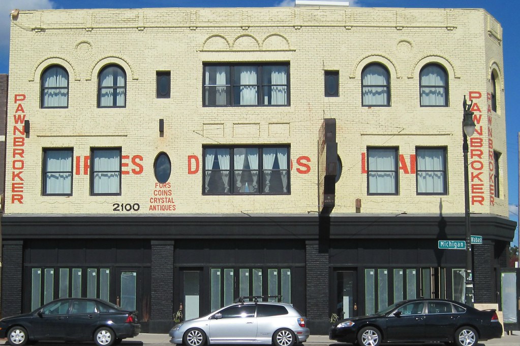
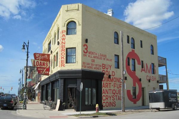
Prior to 1889, only a small, single-story brick building stood on the northwest corner of Michigan Avenue and Wabash. Built in 1878, it was last occupied by wagon maker James Cullen. It stood for about a decade, then was torn down to make way for a much larger structure.
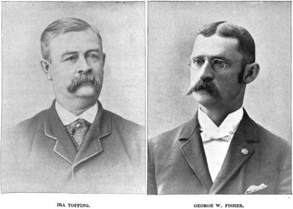
On June 4th, 1889, the Detroit Fire Marshal issued permit #828 to the contracting firm Topping & Fisher for the construction of this mixed-use, three-story building, estimated to cost $12,000. It would contain three commercial spaces on the ground floor with three apartments and offices above. The architect is unknown.
(Source.)
Although the building permit index and a notice in the Detroit Free Press confirm the date of the permit, construction evidently started before that point. The Free Press reported on May 29th of that year that Topping & Fisher's masons went on strike the previous Saturday, May 25th. Of the masons employed, according to the paper, fourteen were working on the new police court building, and eleven were at the Michigan Avenue and Wabash site. They walked off the job after George Fisher's brother, Jerry Fisher, was employed by the firm but refused to join the masons' labor union even after the other workers offered to pay his initiation fee. On June 1, it was reported that work on the court house resumed after fourteen non-union men were hired, but no more information about the Michigan Avenue strikers has been found.
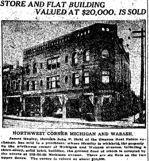
2100 Michigan Ave. as it appeared in a Nov. 17, 1912 Detroit Free Press notice.
Note the decorative brickwork along the roof line that is now missing.
Early Occupants
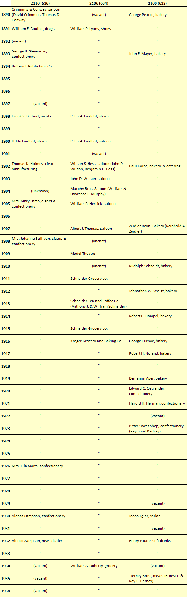
The pre-1921 addresses of the building, from left to right (west to east), were 636, 634, and 632 Michigan Avenue. The first occupant of No. 636 according to the 1890 city directory was Crimmins & Conway, a saloon owned by 26-year-old David Crimmins of 351 14th Street and 31-year-old Thomas D. Conway of 75 Jones Street. Crimmins immigrated from Ireland in 1883, and Conway was born in Michigan to Irish-American parents. Their business did not last more than one year.
The middle unit, No. 634, was not occupied when the 1890 directory was published. But from 1891 through 1897, it was a shoe store owned by 44-year-old William P. Lyons of 392 17th Street. The longest-running tenant to occupy this space before the 1960s was a Kroger grocery store, from 1916 through 1933. Kroger had bought out the Schneider Grocery Co., which had occupied that space since 1911.
The first business to set up shop in the right-hand corner unit, No. 632, was the bakery of George Pearce. Mr. Pearce lived in the flat above his business, but relocated by 1893. His bakery was followed by that of Eugenia and John Mayer. They also lived in the flat above their bakery and operated out of this location for nine years. The subsequent businesses at this address until 1920 would all be bakeries. Note the word "Bakery" barely visible above the doorway in the photograph above.

Source: Detroit Free Press, Dec. 15, 1907.
Not every past tenant of this building will be researched here, but it is worth highlighting at least one early long-term proprietor, Mrs. Johanna Sullivan, owner of a cigar and confectionery store at 636 Michigan Avenue from 1908 through 1925. She was born in Ireland in 1873 as Johanna Fitzgibbon. She immigrated to the United States in 1888 at the age of fifteen. In 1898 she married Cornelius Sullivan, a machinist fellow Irish immigrant. They had at least four children together. On January 24, 1907, Cornelius died from influenza at the age of 35. Johanna and her four children (one of them a newborn) moved from their home on Livernois Avenue to 636 Michigan Avenue where she opened up her confectionery and cigar store in 1908. It remained open at that location for eighteen years, making Mrs. Sullivan the longest-renting proprietor in this building until Sam's Loan Office occupied it decades later.
The building permit index indicates that some renovations occurred in the 1920s. A permit was issued on March 6, 1922 for work on the storefront, and another on March 22, 1922 to convert the offices into additional apartments, increasing the number of living spaces in the building to six. In 1921, the addresses of the building changed from 636, 634, and 632 to 2110, 2106, and 2100.
Below are all of the ground-floor commercial occupants of this building through 1936.
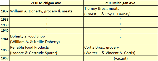
Between 1936 and 1937, William and Nellie Doherty expanded their grocery store at 2106 Michigan Avenue, combining it with the vacant unit at No. 2110. Below are the tenants who occupied this building in the new configuration through the end of the 1950s. Note that very few city directories are available after 1941.
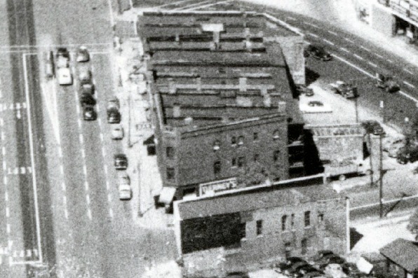
The 2100 block of Michigan Avenue in 1953. The awning on the side reads "Tierney's."
Image courtesy Detroit Historical Society.
All three commercial spaces would be combined into one unit in the early 1960s.
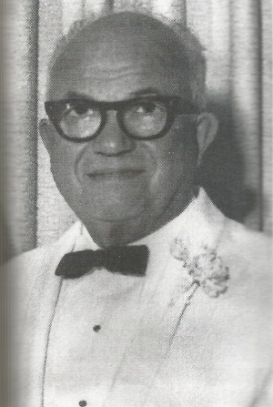
Samuel H. Rubin
Source:
Leslie Gold, For What It's Worth: Business Wisdom from a Pawnbroker (New York: Penguin Group, 2013).
Sam Rubin was born in Poland in 1893 and immigrated to the United States at the age of twelve. Being very poor as a young man, he would collect junk found by the side of the road to sell. He worked tirelessly for a better life, eventually learning the tailor's trade and opening a used clothing and tailor supply business on Hastings Street, which was then the center of Detroit's Jewish community (and has since been bulldozed for the construction of I-75 and I-375). Rubin first went into the clothing business with a man named Meyer Goldberg, and their shop first appears in the city directory of 1913. On December 28 of that year, Rubin married Katherine Sassin, also a Polish immigrant. They were wed by Rabbi Joseph Eisenman of Congregation Beth Tefilo.
Goldberg and Rubin moved their clothing shop north on Hastings Street several times before settling at 3840 Hastings, at the southeast corner of Leland Street. Sam and Katie Rubin lived in the apartment above the store. By 1920, the only name on the business was Samuel Rubin, who had evidently parted ways with Goldberg.
In the 1940s, Rubin opened a pawnshop in Corktown at the southeast corner of Michigan Avenue and Fifth Street. The transition from retailer of used men's clothing to pawnbroker is not as great a leap as it sounds. Historically, clothing was the most valuable commodity owned by working class people, and it was the item most frequently pawned. Some even believe that the word "pawn" derives from the Latin word for cloth. In its early days, Sam's Loan Office sold men's suits, pants, shoes, and hats in addition to jewelry and other items.
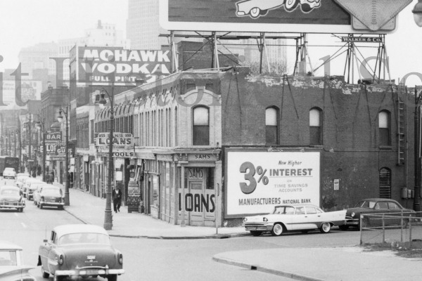
The original Sam's Loans at 955-959 Michigan Ave. in 1959.
Image courtesy Detroit Historical Society.
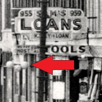
Suspended from the sign for Sam's Loan were three gold balls--the
universal symbol of the pawnbroker, dating back to the Middle Ages.
Image courtesy Detroit Historical Society.
You have probably heard of Sam Rubin's grandson, Les Gold, third-generation pawnbroker and star of the reality TV show Hardcore Pawn. In his book, For What It's Worth: Business Wisdom from a Pawnbroker, Gold writes about growing up around the business, spending Saturdays with his grandfather, whom he called "Popsie." It was in the original Sam's Loan Office at Michigan Avenue and Fifth Street that Gold made his first sale at the age of seven.
According to Gold, his parents (Louis Gold and Shirley Rubin) married after getting pregnant with him. Rubin brought Louis Gold into the family business in order to ensure that his daughter and grandchild would be provided for.
Impregnating my mom was a real stroke of luck for my dad. Before he met her, he had been a pool hustler and worked in a refrigerator factory. But when my grandfather gave him a job at the pawnshop, L.G. had a chance at real success. He had a golden opportunity to learn from Popsie, a man who worked his way up from nothing to build a solid business.The area surrounding the original Sam's Loan Office was known as skid row, and the local businesses consisted largely of flophouses, liquor stores, and other pawnshops. The entire district--including all of the buildings on Michigan Avenue between Cass Avenue and the Lodge Expressway--was condemned in an urban renewal project in 1961 and demolished between 1962 and 1963. It was then that Rubin moved his business from the old Fifth Street location to the building at 2100 Michigan Avenue. Rubin combined the all of the ground-floor commercial spaces into a large, single store.
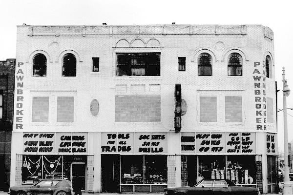
Sam's Loan Office, 2100 Michigan Avenue, in 1976.
Image courtesy State Historic Preservation Office.
Sam Rubin passed away in 1969, and his business continued to operate under his family's management. Les Gold opened a branch location, American Jewelry and Loan, in 1978. In 1981, he parted ways with his father and bought out his share of the new store, running it as an independent business.
Troubled Times
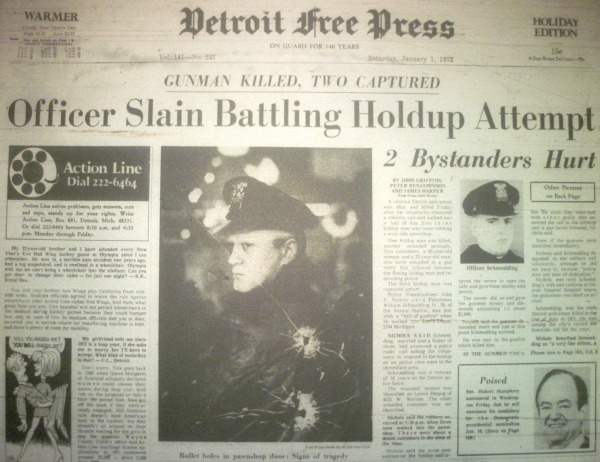
Source: Detroit Free Press, Jan. 1, 1972.
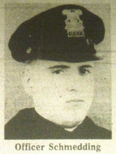
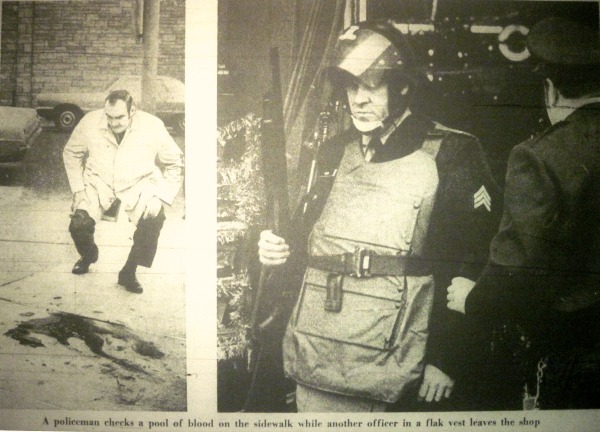
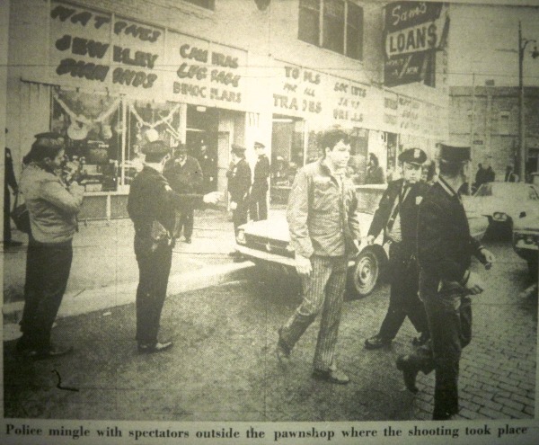
At approximately 1:20pm on December 31, 1971, three armed robbers walked into Sam's Loan Office and demanded money and jewelry. As Louis Gold emptied the safe, he activated a silent alarm, alerting the police. When the call went out, Officer William Schmedding Jr., a sixteen-year Detroit Police veteran, volunteered to respond despite being on patrol alone. When he entered the store, he was met with a barrage of gunfire and killed.
Source: Detroit Free Press, Jan. 1, 1972.
The robbers tried to flee but were met by the other officers responding to the call. One of the robbers, Gus Smith, died in the gunfight that ensued. His brother, Robert J. Smith, was wounded, and Leon Smith (who was not related to the other two) was captured unharmed. Two of the twelve customers at the store were also wounded when they fled the store in a panic and were mistaken for other robbers.
Source: Detroit Free Press, Jan. 1, 1972.
Source: Detroit Free Press, Jan. 1, 1972.
Officer Schmedding was 39 years old when he died, and left behind a wife, two daughters, and a son. He was the sixth Detroit Police Officer to die in the line of duty in 1971.
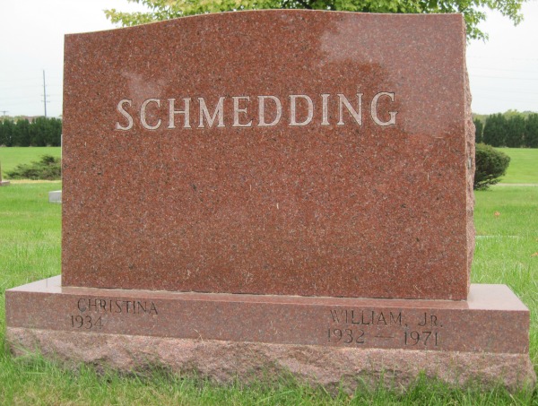
This was far from the only time that Sam's Loan Office was held up. According to Les Gold, the store was robbed on December 5th two years in a row, in 1979 and 1980. After that, one employee refused to work there on December 5th ever again.
The incident in 1971 wasn't the only deadly robbery. On July 2, 1983, three gunmen--Taveen Lakiff Tupper, Charles Ross, and Derrick Mills--entered the store around 1:30pm, pretending to be customers. Mills was disguised as a woman as part of the holdup attempt. When they got close to Louis Gold, they demanded money.
An employee was speaking on the phone to her husband when the robbers entered the back office and hung up the phone. Her husband called back and one of the robbers answered, claiming to be a new employee. Knowing that this was a lie, the husband called the police. When the robbers attempted to flee the store, they saw that the police had arrived. They took Louis Gold hostage and attempted to cross Michigan Avenue to enter Gold's 1982 Cadillac and escape.
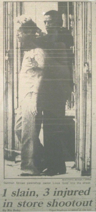
Source: The Detroit News, Jul. 3, 1983.
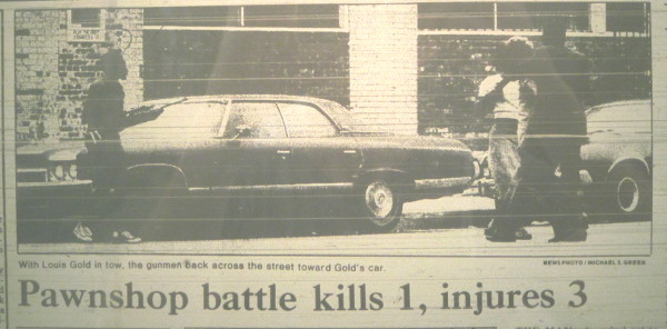
Gunmen attempt to force Gold into his Cadillac, parked in front of 2125 Michigan Ave.
Source: The Detroit News, Jul. 3, 1983.
Before they could enter the car, one of the gunmen's firearms discharged and Gold fell to the ground. The police opened fire on the three. In the gun battle, fifteen police officers fired more than 80 bullets. No officers were injured, but Mills was killed and the other two robbers were injured. Some baseball fans who had watched the Tigers play the Baltimore Orioles that afternoon returned to their cars to find them punctured with bullet holes. Gold had been beaten badly during the robbery attempt, and it was found that he had been shot in the left buttock, but he survived.
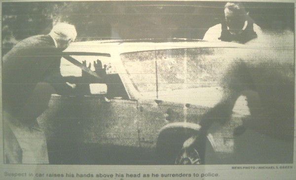
Source: The Detroit News, Jul. 3, 1983.
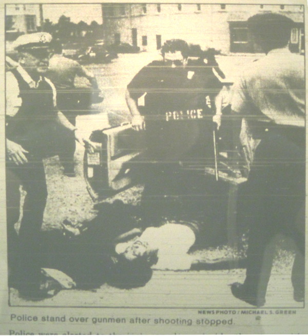
Source: Detroit Free Press, Jul. 3, 1983.
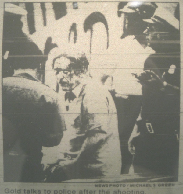
Source: The Detroit News, Jul. 3, 1983.
Louis Gold, who was 60 at the time of the robbery, left the business a few years later. In 1987, the store was run by B & C Jewelry and Loan Corp., owned by William J. Connell of Farmington Hills. The Gold family retained ownership of the building.
"GOLD CASH GOLD"
In 2010, a new business entity named Diamonds and Rifles--a reference to the odd pawnbroker advertisements painted on the building--purchased the building from the heirs of Louis Gold, who passed away in 2008. Diamonds and Rifles is owned by members of the Cooley family, famous for Slow's Bar-B-Q, which opened on the same block in 2005.Under new ownership, the upper floors of the building have already been renovated into six apartments and rented, and the ground floor commercial space will soon open as a comfort foods restaurant called Gold Cash Gold, another reference to the building's odd exterior lettering. Curiously, the new owners have decided to restore the pawnshop-era paint scheme.

Source: Gold Cash Gold's Facebook page.
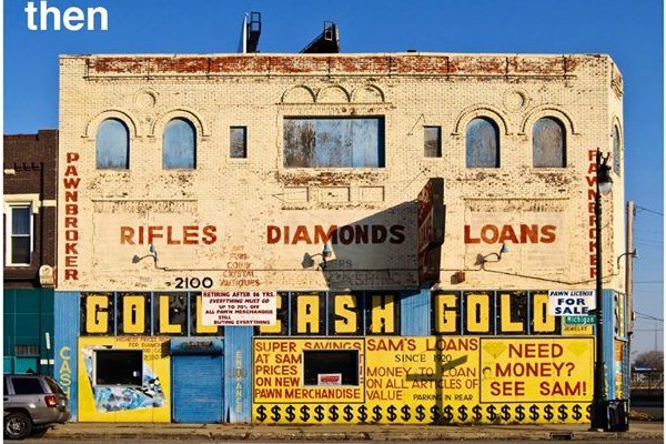
2100 Michigan Avenue cira 2010.
Source: Gold Cash Gold's Facebook page.
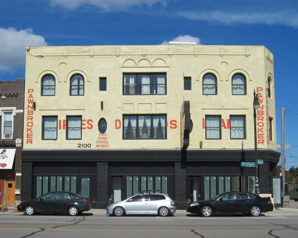
2100 Michigan Avenue, October 2014. Photograph by the author.
Gold Cash Gold is expected to open by November.
Subscribe to:
Posts (Atom)