October 20, 2014

Indian Trails and Woodward's Plan

Last Thursday, michiganradio.org published a story in answer to the question, "8 Mile Road is eight miles from where?" I love everything about the early urban planning history of Detroit and I was glad to see the subject come up in the local media. The essential answer given (that 8 Mile Road is eight miles from Campus Martius in downtown Detroit) is correct, but there were some inaccuracies in the piece that deserve correction.

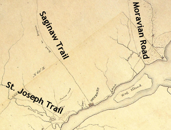
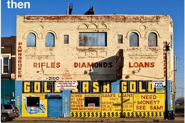
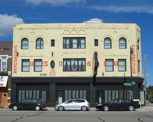
The story claims that the spoke-wheel layout of downtown Detroit is not the work of Augustus Woodward--who of course drew up a new plan for the city after it burned in 1805--but it was based on the Indian trails that converged in Campus Martius. "When Detroit was settled, Campus Martius was deemed the center of town because it was where all of these main roads came together," the author writes.

Campus Martius was not at all the center of early Detroit. The location of the original French fort was chosen for its defendability and convenience, not because of any confluence of Indian trails. There was not yet a settlement (European or Native American) for these trails to converge upon. Old Detroit stood at the water's edge near what is now the intersection of Jefferson Avenue and Shelby Street. The fort gradually grew until it reached about the size of four modern city blocks. In 1779, the British built a more modern military fort north of the old French town at what is now the intersection of Fort and Shelby Streets. Below is a map of Detroit from around 1796 (when the United States took over) with the city's modern street grid superimposed over it. Campus Martius, on the upper right hand corner, was well outside of the settlement.


Even as the city rebuilt following the 1805 fire, some Detroiters scoffed at the idea that the town would ever expand far enough to encompass what is now Campus Martius. John Gentle petitioned President Thomas Jefferson directly, complaining about taxes being wasted on "digging wells and erecting pumps ... near half a mile behind the town of Detroit, where in our opinion no town will ever exist." In the new town's early days, the greatest concentration of buildings was south of Jefferson Avenue, roughly where Hart Plaza is today. As late as 1819, the main streets of the town were Jefferson, Woodbridge, and Atwater, and the north-south streets barely even reached Campus Martius.

The conventional wisdom that the spoke-wheel street pattern of Detroit came from Augustus Woodward's ideas is actually correct. Here is one engraving of his magnificent plan:


The English-built fort, just west of Campus Martius, gives us a reference point for understanding its relation to the old settlement. Why did Woodward place Campus Martius, the center of the new city, where he did? It was simply because it was in the middle of the public grounds. Under French rule, none of the land immediately outside of the fort was ever granted to private individuals. It was surrounded by a large common area which was flanked on either side by privately owned ribbon farms.


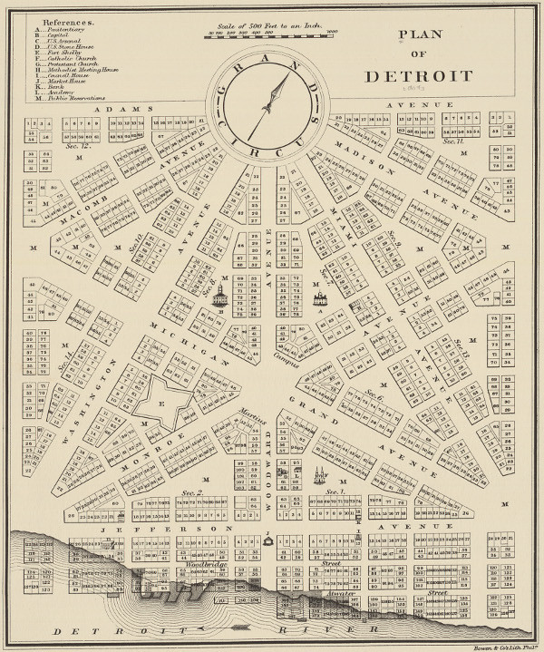
How do we know that our spoke-wheel roads are based on Woodward's plan? Let's look at how the plan is organized. Its foundation is a 4,000-foot equilateral triangle, outlined in green below. The triangle is bisected three times with streets (outlined in orange) that all intersect at Campus Martius.


Woodward's plan, if it was allowed to be fully carried out, would look like this, if the map is rotated so that due north is straight up:


The scheme viewed from farther out:


There are differences between this plan and the roads we have today, which I will get to in a moment. The point here is that these roads are all based on the bisected equilateral triangle, yielding avenues separated from one another by 30° angles. Indian trails followed the land, sticking to high ground, avoiding obstacles, crossing streams at their narrowest point. The roads built by the United States government cut straight, rigid paths through the land. Indian trails were unplanned, unmapped, and developed emergently under the feet of travelers following the most convenient route to a destination. They might branch out and reconnect, and did not have pinpoint beginnings and endings. Indian trails and Woodward's plan are two very different systems with very different origins.

How do today's roads diverge from Woodward's plan? First, Washington Avenue never continued north of Grand Circus Park. Second, Gratiot Avenue was built one block north of where it "should" have been because the owner of the Brush Farm had an orchard that was in the way. And third, Grand River Avenue didn't extend through Grand Circus Park from Miami Avenue (which is now named Broadway) but it is two blocks south of that. This is probably because Grand Circus Park was a swamp when construction began on Grand River Avenue in 1832.


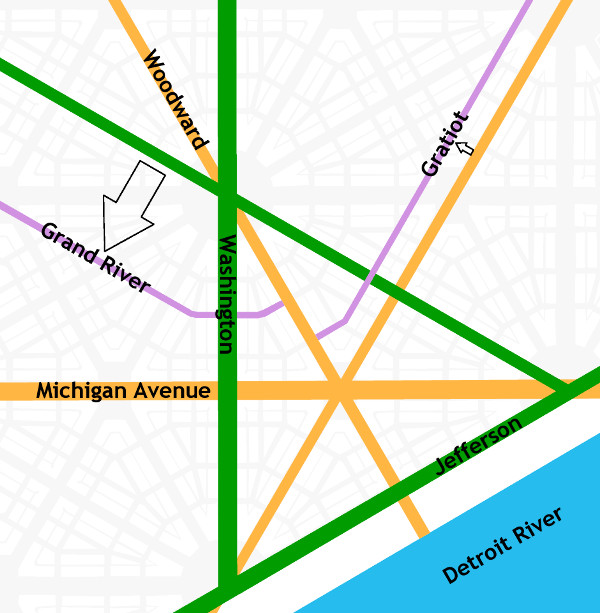
Having said all that, didn't some of our roads begin as Indian trails? Definitely. US-24 between Detroit and Toledo mostly lies upon an old segment of the Maumee Trail, expanded and improved upon by the U.S. government in 1814. Much of the St. Joseph Trail is preserved by various rural highways. Shiawassee Road in Farmington coincides with an Indian trail that appears in an 1817 survey:


If I do make one concession to the idea that Woodward's plan is connected to the Indian trails, it would be to say that Woodward Avenue did replace the old Saginaw Trail between Detroit and Pontiac. This path appears on an 1817 survey of Royal Oak Township (which was once a six-mile-by-six-mile square bound by 8 Mile Rd., Dequindre, 14 Mile Rd., and Greenfield). Here is that path (which splits into two and then comes together again) superimposed over a modern map of the area:


When you are driving on Woodward Avenue in Detroit, you aren't exactly retracing the steps of the Native Americans and pioneers of two centuries ago, but you are at least headed in approximately the same direction.

It is claimed that Michigan Avenue (US-12) follows the Sauk Trail. This is true for much of US-12 in the middle of the state, but it is not true of Michigan Avenue within today's Detroit city limits. Michigan Avenue begins at Campus Martius and heads in a straight line due west for almost five miles before turning south to eventually meet the old Indian path many miles later. Most likely, it appears that eastbound travelers on the Sauk Trail came to Detroit by first arriving at the River Raisin, following it down to the Detroit River, and then following the shoreline upstream to Detroit.

Some say that Gratiot Avenue follows the old Moravian Road, but that is not correct. The Moravian Road actually began at Connor's Creek, 4.5 miles east of Campus Martius. It curved to the northeast and ended at the Moravians' settlement in what is now Harrison Township. Gratiot Avenue begins in downtown Detroit, runs in a straight line for fifteen miles before its first curve, and terminates in Port Huron. These roads head in roughly the same direction, but one is not based on the other.


Detroit and vicinity circa 1797.
Source: King, Robert after Patrick McNiff. A Rough Sketch of part of Wayne County Territory of theUnited States North-west of the River Ohio [map]. In: Dunnigan, Brian L. Frontier Metropolis: Picturing Early Detroit, 1701-1838. Detroit: Wayne State University Press, 2001, p. 106.

Grand River Avenue has a similar story to Michigan Avenue. It is often claimed to be an Indian trail, but that is only true for some portions well within the interior of the state. It began as a road to Howell before being extended to the west side of Michigan. Perhaps it is confused with the Shiawassee trail, which intersected Grand River Avenue in downtown Farmington. This trail appears to begin well west of the settlement at Detroit, and heads north to Saginaw after passing through Farmington.


Detail from an 1825 survey of Michigan, showing the Shiawassee Trail. (Source.)

There is SO MUCH MORE that I wish I could write about. I didn't even mention the Woodward plan's Point of Origin, which you can see in Campus Martius Park; or the amazing Public Land Survey System; or the beautiful connection between the two, or their relationship to 8 Mile Road (which, by the way, has nothing to do with the Wisconsin/Illinois border as the article also claims).

Thank you, Michigan Radio, for bringing up my favorite subject! Honestly, this has made me want to start a whole new blog just about the urban planning history of Detroit.

October 13, 2014

Sam's Loan Office -- aka "Gold Cash Gold"


Prior to 1889, only a small, single-story brick building stood on the northwest corner of Michigan Avenue and Wabash. Built in 1878, it was last occupied by wagon maker James Cullen. It stood for about a decade, then was torn down to make way for a much larger structure.

On June 4th, 1889, the Detroit Fire Marshal issued permit #828 to the contracting firm Topping & Fisher for the construction of this mixed-use, three-story building, estimated to cost $12,000. It would contain three commercial spaces on the ground floor with three apartments and offices above. The architect is unknown.


(Source.)

Although the building permit index and a notice in the Detroit Free Press confirm the date of the permit, construction evidently started before that point. The Free Press reported on May 29th of that year that Topping & Fisher's masons went on strike the previous Saturday, May 25th. Of the masons employed, according to the paper, fourteen were working on the new police court building, and eleven were at the Michigan Avenue and Wabash site. They walked off the job after George Fisher's brother, Jerry Fisher, was employed by the firm but refused to join the masons' labor union even after the other workers offered to pay his initiation fee. On June 1, it was reported that work on the court house resumed after fourteen non-union men were hired, but no more information about the Michigan Avenue strikers has been found.


2100 Michigan Ave. as it appeared in a Nov. 17, 1912 Detroit Free Press notice.
Note the decorative brickwork along the roof line that is now missing.


Early Occupants


The pre-1921 addresses of the building, from left to right (west to east), were 636, 634, and 632 Michigan Avenue. The first occupant of No. 636 according to the 1890 city directory was Crimmins & Conway, a saloon owned by 26-year-old David Crimmins of 351 14th Street and 31-year-old Thomas D. Conway of 75 Jones Street. Crimmins immigrated from Ireland in 1883, and Conway was born in Michigan to Irish-American parents. Their business did not last more than one year.

The middle unit, No. 634, was not occupied when the 1890 directory was published. But from 1891 through 1897, it was a shoe store owned by 44-year-old William P. Lyons of 392 17th Street. The longest-running tenant to occupy this space before the 1960s was a Kroger grocery store, from 1916 through 1933. Kroger had bought out the Schneider Grocery Co., which had occupied that space since 1911.

The first business to set up shop in the right-hand corner unit, No. 632, was the bakery of George Pearce. Mr. Pearce lived in the flat above his business, but relocated by 1893. His bakery was followed by that of Eugenia and John Mayer. They also lived in the flat above their bakery and operated out of this location for nine years. The subsequent businesses at this address until 1920 would all be bakeries. Note the word "Bakery" barely visible above the doorway in the photograph above.


Source: Detroit Free Press, Dec. 15, 1907.

Not every past tenant of this building will be researched here, but it is worth highlighting at least one early long-term proprietor, Mrs. Johanna Sullivan, owner of a cigar and confectionery store at 636 Michigan Avenue from 1908 through 1925. She was born in Ireland in 1873 as Johanna Fitzgibbon. She immigrated to the United States in 1888 at the age of fifteen. In 1898 she married Cornelius Sullivan, a machinist fellow Irish immigrant. They had at least four children together. On January 24, 1907, Cornelius died from influenza at the age of 35. Johanna and her four children (one of them a newborn) moved from their home on Livernois Avenue to 636 Michigan Avenue where she opened up her confectionery and cigar store in 1908. It remained open at that location for eighteen years, making Mrs. Sullivan the longest-renting proprietor in this building until Sam's Loan Office occupied it decades later.

The building permit index indicates that some renovations occurred in the 1920s. A permit was issued on March 6, 1922 for work on the storefront, and another on March 22, 1922 to convert the offices into additional apartments, increasing the number of living spaces in the building to six. In 1921, the addresses of the building changed from 636, 634, and 632 to 2110, 2106, and 2100.

Below are all of the ground-floor commercial occupants of this building through 1936.


Between 1936 and 1937, William and Nellie Doherty expanded their grocery store at 2106 Michigan Avenue, combining it with the vacant unit at No. 2110. Below are the tenants who occupied this building in the new configuration through the end of the 1950s. Note that very few city directories are available after 1941.


The 2100 block of Michigan Avenue in 1953. The awning on the side reads "Tierney's."
Image courtesy Detroit Historical Society.

All three commercial spaces would be combined into one unit in the early 1960s.


Samuel H. Rubin


Source:
Leslie Gold,
For What It's Worth: Business Wisdom from a Pawnbroker (New York: Penguin Group, 2013).

Sam Rubin was born in Poland in 1893 and immigrated to the United States at the age of twelve. Being very poor as a young man, he would collect junk found by the side of the road to sell. He worked tirelessly for a better life, eventually learning the tailor's trade and opening a used clothing and tailor supply business on Hastings Street, which was then the center of Detroit's Jewish community (and has since been bulldozed for the construction of I-75 and I-375). Rubin first went into the clothing business with a man named Meyer Goldberg, and their shop first appears in the city directory of 1913. On December 28 of that year, Rubin married Katherine Sassin, also a Polish immigrant. They were wed by Rabbi Joseph Eisenman of Congregation Beth Tefilo.

Goldberg and Rubin moved their clothing shop north on Hastings Street several times before settling at 3840 Hastings, at the southeast corner of Leland Street. Sam and Katie Rubin lived in the apartment above the store. By 1920, the only name on the business was Samuel Rubin, who had evidently parted ways with Goldberg.

In the 1940s, Rubin opened a pawnshop in Corktown at the southeast corner of Michigan Avenue and Fifth Street. The transition from retailer of used men's clothing to pawnbroker is not as great a leap as it sounds. Historically, clothing was the most valuable commodity owned by working class people, and it was the item most frequently pawned. Some even believe that the word "pawn" derives from the Latin word for cloth. In its early days, Sam's Loan Office sold men's suits, pants, shoes, and hats in addition to jewelry and other items.


The original Sam's Loans at 955-959 Michigan Ave. in 1959.
Image courtesy Detroit Historical Society.


Suspended from the sign for Sam's Loan were three gold balls--the
universal symbol of the pawnbroker, dating back to the Middle Ages.
Image courtesy Detroit Historical Society.

You have probably heard of Sam Rubin's grandson, Les Gold, third-generation pawnbroker and star of the reality TV show Hardcore Pawn. In his book, For What It's Worth: Business Wisdom from a Pawnbroker, Gold writes about growing up around the business, spending Saturdays with his grandfather, whom he called "Popsie." It was in the original Sam's Loan Office at Michigan Avenue and Fifth Street that Gold made his first sale at the age of seven.

According to Gold, his parents (Louis Gold and Shirley Rubin) married after getting pregnant with him. Rubin brought Louis Gold into the family business in order to ensure that his daughter and grandchild would be provided for.
Impregnating my mom was a real stroke of luck for my dad. Before he met her, he had been a pool hustler and worked in a refrigerator factory. But when my grandfather gave him a job at the pawnshop, L.G. had a chance at real success. He had a golden opportunity to learn from Popsie, a man who worked his way up from nothing to build a solid business.
The area surrounding the original Sam's Loan Office was known as skid row, and the local businesses consisted largely of flophouses, liquor stores, and other pawnshops. The entire district--including all of the buildings on Michigan Avenue between Cass Avenue and the Lodge Expressway--was condemned in an urban renewal project in 1961 and demolished between 1962 and 1963. It was then that Rubin moved his business from the old Fifth Street location to the building at 2100 Michigan Avenue. Rubin combined the all of the ground-floor commercial spaces into a large, single store.


Sam's Loan Office, 2100 Michigan Avenue, in 1976.
Image courtesy State Historic Preservation Office.

Sam Rubin passed away in 1969, and his business continued to operate under his family's management. Les Gold opened a branch location, American Jewelry and Loan, in 1978. In 1981, he parted ways with his father and bought out his share of the new store, running it as an independent business.


Troubled Times


Source: Detroit Free Press, Jan. 1, 1972.

At approximately 1:20pm on December 31, 1971, three armed robbers walked into Sam's Loan Office and demanded money and jewelry. As Louis Gold emptied the safe, he activated a silent alarm, alerting the police. When the call went out, Officer William Schmedding Jr., a sixteen-year Detroit Police veteran, volunteered to respond despite being on patrol alone. When he entered the store, he was met with a barrage of gunfire and killed.


Source: Detroit Free Press, Jan. 1, 1972.

The robbers tried to flee but were met by the other officers responding to the call. One of the robbers, Gus Smith, died in the gunfight that ensued. His brother, Robert J. Smith, was wounded, and Leon Smith (who was not related to the other two) was captured unharmed. Two of the twelve customers at the store were also wounded when they fled the store in a panic and were mistaken for other robbers.


Source: Detroit Free Press, Jan. 1, 1972.


Source: Detroit Free Press, Jan. 1, 1972.

Officer Schmedding was 39 years old when he died, and left behind a wife, two daughters, and a son. He was the sixth Detroit Police Officer to die in the line of duty in 1971.


This was far from the only time that Sam's Loan Office was held up. According to Les Gold, the store was robbed on December 5th two years in a row, in 1979 and 1980. After that, one employee refused to work there on December 5th ever again.

The incident in 1971 wasn't the only deadly robbery. On July 2, 1983, three gunmen--Taveen Lakiff Tupper, Charles Ross, and Derrick Mills--entered the store around 1:30pm, pretending to be customers. Mills was disguised as a woman as part of the holdup attempt. When they got close to Louis Gold, they demanded money.

An employee was speaking on the phone to her husband when the robbers entered the back office and hung up the phone. Her husband called back and one of the robbers answered, claiming to be a new employee. Knowing that this was a lie, the husband called the police. When the robbers attempted to flee the store, they saw that the police had arrived. They took Louis Gold hostage and attempted to cross Michigan Avenue to enter Gold's 1982 Cadillac and escape.


Source: The Detroit News, Jul. 3, 1983.


Gunmen attempt to force Gold into his Cadillac, parked in front of 2125 Michigan Ave.
Source: The Detroit News, Jul. 3, 1983.

Before they could enter the car, one of the gunmen's firearms discharged and Gold fell to the ground. The police opened fire on the three. In the gun battle, fifteen police officers fired more than 80 bullets. No officers were injured, but Mills was killed and the other two robbers were injured. Some baseball fans who had watched the Tigers play the Baltimore Orioles that afternoon returned to their cars to find them punctured with bullet holes. Gold had been beaten badly during the robbery attempt, and it was found that he had been shot in the left buttock, but he survived.


Source: The Detroit News, Jul. 3, 1983.


Source: Detroit Free Press, Jul. 3, 1983.


Source: The Detroit News, Jul. 3, 1983.

Louis Gold, who was 60 at the time of the robbery, left the business a few years later. In 1987, the store was run by B & C Jewelry and Loan Corp., owned by William J. Connell of Farmington Hills. The Gold family retained ownership of the building.


"GOLD CASH GOLD"

In 2010, a new business entity named Diamonds and Rifles--a reference to the odd pawnbroker advertisements painted on the building--purchased the building from the heirs of Louis Gold, who passed away in 2008. Diamonds and Rifles is owned by members of the Cooley family, famous for Slow's Bar-B-Q, which opened on the same block in 2005.

Under new ownership, the upper floors of the building have already been renovated into six apartments and rented, and the ground floor commercial space will soon open as a comfort foods restaurant called Gold Cash Gold, another reference to the building's odd exterior lettering. Curiously, the new owners have decided to restore the pawnshop-era paint scheme.


Source: Gold Cash Gold's Facebook page.


2100 Michigan Avenue cira 2010.
Source: Gold Cash Gold's Facebook page.


2100 Michigan Avenue, October 2014. Photograph by the author.

Gold Cash Gold is expected to open by November.

September 30, 2014

The Henry Hart Map of 1853

In 1853, New York surveyor Henry Hart published a map of Detroit that indicated the location of every building within the city limits. This map not only allows us to see the state of the development of Corktown, which was still a new neighborhood, but it can help us determine which houses in Corktown are the oldest. This is not always easy--building permits were not required until 1878, and city directories can be inconsistent and incomplete.

At the time, the western border of the city roughly coincided with Eighth Street. The area beyond that would have still been part of Springwells Township, and was excluded from the document. Just over the border was the Woodbridge Farm, which wasn't legally subdivided into individual building lots until 1858.

Until now, I have only had access to low-resolution images of the Hart map. But I recently noticed that the Detroit Historical Society has a copy of this map in their online archives, and a high-resolution version available to paid members. Below is a detail of the area including Corktown.


Image courtesy Detroit Historical Society.

Superimposing this map over a modern aerial photograph can help researchers determine which structures in Corktown were built before 1853.


The houses that I believe coincide with existent structures are highlighted in yellow. Some buildings appear to coincide with the 1853 map, but they are known to have been built afterward. For example, today's Most Holy Trinity Church was built after the older wooden structure was demolished in June 1856.

Of the small handful of houses in Detroit that predate the publication of Hart's map, these seven can be found in Corktown.


• 1362 Bagley. The house next door to this one (1366 Bagley) probably also dates to the 1850s.


• 1232 Labrosse. According to the Detroit Historic Designation Advisory Board, the John Purdon house was constructed around 1851. Like many of the other houses on this list, this home would have had a very simple design originally, with Victorian details being added at a later date.


• 1319 Labrosse. I am least confident about the date of this house, but if it does predate 1853, then the corbels, window bay and window hood are clearly Victorian additions.


• 1323 Labrosse. The booklet from the 1994 Corktown Historic Homes Tour calls this the Hall House and dates it to 1848.


• 1337-1339 Labrosse. The porch on this duplex is not original to the structure. When first built, it would have looked similar to the Worker's Row House, pictured below.


• 1430-1438 Sixth St. Previous research on the building indicates that it was probably built in 1849, or not long after.


• 1200 Porter. Confirmation that the Michael Keenan House was built by 1853 is found in an 1852 re-subdivision of the block, which indicates a house already existing on the lot at the time.

September 24, 2014

Stereoscopic Images

I recently learned that "wigglegrams" (brief animated GIFs that create an illusion of three-dimensional space) can be made from old stereoscopic images. I have made a few out of the few vintage stereoscopic images of Corktown that I'm aware of.

The one that turned out the best was of the former Trumbull Avenue Congregational Church, once located on the northeast corner of Trumbull and Bagley Avenues. It was built in 1868 and moved to this location in 1881. It was replaced by a larger building that was torn down by 1950, and today the space is occupied by the parking lot for St. Cece's Pub.


The other stereoscopic Corktown images do not offer the same amount of dramatic movement, but I have included them here anyway.

This photo is of Immanuel Evangelical Lutheran Church, built on Trumbull Ave. for Corktown's growing population of German-speaking Lutherans in 1865. The congregation moved to a new brick building at Pine Seventeenth Streets in 1873 and took the old wooden structure with them to use as a school. Today this spot is occupied by the vacant lot in between Checker Cabs and UFO Factory.


The Detroit Fire Department's firehouse for Engine Company No. 8 was constructed in 1871 at the southwest corner of Bagley and Sixth Streets. It was replaced by a new structure in 1918, which is still standing, but converted into offices.


Other images that might technically fall within Corktown's borders are of stately brick mansions that once lined Lafayette and Fort Streets before the encroachment of industry.

Click here for a wigglegram made from photos taken from Detroit's Old City Hall, looking east across Campus Martius.

September 2, 2014

Daniel O. Donovan House - 1221 Bagley


The index to building permits for the City of Detroit contains two entries for 11 Baker Street, the original address of this home. It is not clear why. The first permit was issued on November 6, 1878, and the second on July 21, 1879. The Detroit Free Press announced on July 27, 1879 that this second permit was issued to John Brennan, and that the construction was estimated to cost $650. At the time, the house stood on half of the same lot occupied by the home of William B. and Lacyra Wesson, the brick Greek Revival home now addressed as 1227 Bagley.

On December 20, 1880, the Wessons sold 11 Baker Street to Rose V. Lane for $2,069.33. Mrs. Lane was born Rose Virginia Sherlock in Detroit in 1856, and married Thomas H. Lane around 1877. Mr. Lane was born in Lawrence, Massachusetts in 1850. He was a shoemaker with a store on Monroe Street. Both Mr. and Mrs. Lane were first-generation Americans whose parents were Irish immigrants. Mr. and Mrs. Lane had lived at 11 Baker Street since it was built, although the purchase was not made until 1880.

Rose Lane sold 11 Baker street to Mary Moynahan for $3,350 in July of 1882. This is an example of 19th century Corktown's tradition of female home ownership. In Irish households at the time, wives were in charge of the domestic finances, and property was often held in their names.


11 Baker St. in 1884. The front part of the house had two stories and was attached to several
one-story additions. The house would have had a very different appearance at the time.

The home's new owner, Mary Moynahan, was a first-generation Irish-Canadian, born in Ontario in 1846. Her husband, Matthew J. Moynahan, was an Irish immigrant. The couple married around 1876 and had two children. Two years after moving into the home, Matthew Moynahan passed away. Mrs. Moynahan was listed at 11 Baker Street through 1887, after which she rented the house to Martha Fessenden, a widow. One of Mrs. Fessenden's son's, Mark, died at the home on February 15, 1889, at the age of 26.

Other boarders listed at this address in 1887 and 1888 included Thomas W. Richardson, a porter for Thorp, Hawley & Co.; Walter Parrish, a lineman for the Brush Electric Co.; and Frank Hutchinson, a clerk.


Daniel & Isabelle Donovan


On June 5, 1889, Mrs. Moynahan sold 11 Baker Street to Daniel and Isabelle Donovan for $4,000.

Daniel O. Donovan was born outside of Chatham, Ontario on October 28, 1851 to Irish immigrants John and Helen (Driscoll) Donovan. At the age of 21, he began his study of medicine, ultimately receiving a Doctorate of Medicine from the University of Michigan in 1876. He practiced in Manistee and Ludington, Michigan before moving to Corktown in 1881.

Dr. Donovan was united in marriage to Isabelle Genevieve Lynch by James Savage of Most Holy Trinity Church on April 30, 1889. Miss Lynch, a first-generation Irish-American, was born in Detroit in 1858. Dr. and Mrs. Donovan purchased the Baker Street home just a few weeks after their marriage.


Isabelle and Daniel Donovan and their five children,
Edna, Daniel Raymond, Ella, Florence, and Marian.
Photo courtesy of Colleen Mahan.

In addition to the children pictured above, Dr. and Mrs. Donovan had a baby girl, Mary Isabelle, born in 1904, but died at less than four months in age.


"Old Corktown's Physician"


11 Baker Street was not only the Donovan family's home, but it served as Dr. Donovan's home office for forty-six years of his sixty-year medical career. Patients did not always need to come to the house, however, since doctors in those days very frequently made house calls.


Dr. Daniel O. Donovan, circa 1920s.
Burton Historical Collection, Detroit Public Library.

At the end of his life, obituaries referred to him as Old Corktown's physician. The Detroit News related:
his commanding figure, dressed in a Prince Albert coat and topped by a hat of the style worn by Civil War veterans on parade, was a familiar one on the streets of Detroit between Cass and Trumbull avenues and Grand River avenue and Fort street, the heart of Corktown. He made his rounds on foot. There wasn't an Irishman who didn't know Dr. Donovan's home next to the fire engine house at Sixth and Bagley, then Baker Street. ... His practice, friends relate, was extensive enough to have made him a rich man, but he was the type who gave freely of his services and many of his patients were poor.


Home Addition


In 1898, the old house was renovated and partially rebuilt, giving it an entirely new look. This was at a time of an upward social mobility of Corktown's residents--the poor, hardworking immigrants who founded the neighborhood grew into a middle class, well-educated and more integrated into American culture. Small worker's cottages were torn down and replaced with larger homes at the turn of the 20th century. The new facade of 11 Baker Street, which some have classified as late Victorian/Colonial Revival, would have been keeping up with these changes.

A notice printed in the Detroit Free Press of April 24, 1898 stated:
Architects Grenier & McLain [sic] are receiving bids for building a two-story frame veneered dwelling, to be erected on the southeast corner of Lafayette avenue and Nineteenth street. Arthur Lefevre is the owner. Also, for a two-story frame residence, located on the corner of Baker and Sixth streets. Dr. Donovan is the owner.
The architecture firm mentioned had just been organized that year by Frank J. Grenier of Detroit and Joseph G. McLean of Windsor.

It does not appear that 11 Baker Street was demolished and a new home built from scratch. On May 4, 1898, permit #128 was issued to builders Reynolds & Dolan for a two-story wood addition to the front of the home, measuring 24 feet by 15 feet. The estimated cost was $1,100. No incorporated firm by the name of Reynolds and Dolan was listed in the city directory, but it's likely that this refers to Henry Reynolds, a builder listed on Sidney Street; and carpenter Edward B. Dolan of Gratiot Avenue.


There is no way to know what the house looked like before this renovation, but the Sanborn maps reveal some clues. Before the addition, the home consisted of a front section two stories high and a one-story rear section. Following the renovation, most of the home was stories tall. A set of bay windows on the second floor of the west side and a large front porch have been added. The new second-story sleeping porch was almost certainly part of the 1898 addition, as the concept became popular at the turn of the 20th century for its reported health benefits.


Tragedy


Before the days of modern snow plows, horse-drawn bobsleds were a common method of transportation in winter months. A bobsled driven by John Palmer for pork producer Raymond S. Webb was traveling south on Sixth Street from Michigan Avenue around noon on Saturday, February 4, 1905. Two of the Donovan girls--Marian, age 9; and Edna, age 11--were playing on a sidewalk with a group of other children when Palmer rode by. They ran up and hitched a ride by jumping on the back of the sled.

The bobsled made a left-hand turn onto Abbott Street, which used to run farther east before the construction of the Lodge Freeway. In the process, the sled crossed street car lines on Abbott. Mr. Palmer's view of eastbound traffic was blocked by a saloon on the northwest corner of the intersection, as well as a large grocery truck stopped in the westbound lane. Just as the sled was crossing the tracks, it was hit by an eastbound street car, Baker car no. 379.

Marian Donovan was the most severely injured of the children, having suffered a crushed pelvis and legs. Fifteen-year-old John O'Donnell of 155 Beech Street suffered a fractured skull. The sled driver and the other children were injured, but not severely. A fireman nearby called the local hospitals by telephone and several ambulances arrived. Mrs. Donovan was alerted of the accident and went with Marian in the ambulance to Emergency Hospital at the southwest corner of Porter and Second Streets. Dr. Donovan was out making house calls, but was found and brought to the hospital. The Detroit Free Press reported:
At the hospital, everything possible was done for the little Donovan girl... It was immediately seen by Dr. Stapleton that the girl could not recover. Her father and mother staid by until the end came, shortly after 2 o'clock. Fr. Savage arrived at the hospital in time to administer the rites of the church to the little girl before she passed away. She was unconscious and in a delirium and sang occasionally Good-Bye, Little Girl, Good-Bye," a song now popular with the children.


The Detroit Free Press of February 5, 1905.

Marian's funeral was held at her home and at Most Holy Trinity Church on the morning of Tuesday, February the 7th, 1905. Four of her classmates were pallbearers. The scene was described by the Free Press:
Many beautiful floral pieces have been sent to the grief stricken home. Among the number was a handsome piece from the members of Engine Co. No. 8, which is stationed near the dead child's home. Marion was a favorite with the firemen and her daily visit to their quarters will be greatly missed.
The home and church were filled with friends, family and neighbors paying their last respects. At the church, the hymns "Nearer, My God, to Thee" and "Face to Face" were sung in addition to a requiem mass. According to the Free Press:

While the coffin was being carried out of the church, a Sherman street car bore down upon the hearse and a collision was narrowly averted. One side of the hearse was scraped by the car...

Undertaker Frank J. Blake says that the car which hit his hearse is the one that ran into the sleigh and caused the death of the child whose remains were being interred.


Marian C. Donovan's grave at Mount Elliott Cemetery, Detroit.


Other Members of the Donovan Family


Of the six children born to Dr. and Mrs. Donovan, four reached adulthood:

  • Florence (1891-1985) Enjoyed a long career as a teacher in the Detroit Public Schools. Never married.
  • Ella (1890-1980) Lived with her sister Florence, but did not work due to ill health.
  • Daniel Raymond "Dr. Ray" (1893-1960) Became a physician and served in the U.S. Army 302nd Medical Corps in World War I, receiving a Bronze Star. Married Married Rheta Grace McCubbin in the 1920s, but the couple did not have any children.
  • Edna (1894-1968) Married Theophilus Mahan in 1925, had three children.


Dr. Daniel Raymond Donovan, son of Dr. Daniel O. Donovan.
Burton Historical Collection, Detroit Public Library.

Colleen Mahan, a great-granddaughter of Dr. Daniel O. Donovan, has shared with me some of the memories of the family homestead passed down by her Aunt Mary (a daughter of Edna [Donovan] Mahan) and Great-Aunt Florence Donovan. The following information comes from these relatives. Although Dr. Donovan did make some house calls on foot, there was also a barn at the rear of the property where a horse and carriage were kept for longer distances. Dr. Donovan hired an elderly African-American man to tend to the horses and drive the carriage, and he ate his meals in the family's kitchen. When automobiles became common, Dr. Donovan purchased a Plymouth, but he never learned to drive. Instead, his daughter Florence would drive him. The house was situated next to the Detroit Fire Department's Engine Co. No. 8, and if the firefighters had to rush off to a fire, the family would go next door to ensure that the stove burners were turned off if the firemen were in the middle of cooking. Beggars would collect food from the side door of the home, and when one did, he would mark the stepping stone at the curb (for climbing into carriages) with a piece of chalk, presumably to let other transients know that the house had already given that day.


Detail from a photograph of Engine Company No. 8, built in 1918 to replace an
older building on that site. The Donovan house barely appears at the edge of
the photo, which was probably taken soon after the firehouse's completion.
Image courtesy of the Manning Brothers Historic Photo Collection.

Isabelle Donovan died on April 21, 1928. Her husband survived her by eight years, passing away at home on July 13, 1936. He remained active in medicine until the end of his life, as his obituary in The Detroit News noted: "In later years he attempted something of a retirement, but until the last he received patients at his home and even made calls on old friends who insisted on having his advice and care."


The Donovan family plot at Mount Elliott Cemetery, Detroit.


Anthony & Jessie Xerri


On September 20, 1937, the children of Daniel and Isabelle Donovan sold the home they grew up in to Anthony and Jessie Xerri. By then, the address had changed from 20 Baker Street to 1221 Bagley.

Anthony Xerri was born in Victoria, on the island of Gozo, part of the nation of Malta, on January 8, 1896. He was employed as an auto worker at Ford. Giuseppa "Jessie" (Mallia) Xerri was born in Hamrun, Malta, in 1907. The couple had three children: Mary, Joseph, and John.


1221 Bagley Avenue in 1976.
Photo courtesy of the State Historic Preservation Office of Michigan.

Anthony Xerri spend the last 47 years of his life in this home, passing away September 7, 1984.

On May 10th, 1985, Jessie Xerri sold 1221 Bagley to Barbara Anderson. She has since married John Prusak, and the couple continue to lovingly maintain the home of "Old Corktown's Physician."