

People occasionally ask me--and I've seen the question come up in online discussion groups more than once--what the boundaries of Corktown are. The short answer is that there aren't any exact borders. A neighborhood is an idea that develops emergently, and it's based on the characteristics of its people, architecture, and geography. Whether an area is considered part of a neighborhood or not can change over time, or not even be completely agreed up on from the start. In All Our Yesterdays: A Brief History of Detroit (1969), authors Frank Bury Woodford and Arthur M. Woodford wrote:
Corktown existed almost as much in sentiment as in geography as its borders are rather vaguely defined. Some place it between Lafayette and Myrtle [now Martin Luther King Jr. Blvd.] with its eastern boundary at First Street and its western limit at Brooklyn or even beyond. But many an Irish-Detroiter born outside these boundaries claimed Corktown as his native hearth...
Old Corktown
The oldest published geographic description of Corktown that I have found appears in Silas Farmer's The History of Detroit and Michigan, published in 1884. He defined the neighborhood as:
the larger portion of the territory on Fifth and Sixth Streets, for several blocks each side of Michigan Avenue...A profile of the neighborhood published in the June 19, 1919 edition of the Detroit Free Press explained that Irish immigrants in the early 19th century first settled along the river. Later, they were attracted to the west side after several farms were divided into individual lots for sale:
The Irish, who were home makers, crowded over into the new addition to the city and became almost the exclusive occupants of the territory between Third and Eighth streets and the river to the Grand River road. The concentration was south of Michigan Avenue.When searching for more definite boundaries of early Corktown, the most common outline given is that which is described in the following example. On September 4, 1947, the The Detroit News published a question from a reader identified only as "F.R.", who wrote:
Ever since coming to Detroit people have been telling me of a neighborhood called Corktown. Could you give me some information about it? What were its boundaries? Did many prominent people come from there?"The editor replied:
Detroit's Corktown had its origin in the disasterous [sic] potato famine in Ireland (1845-47), which forced much of the population to emigrate. Many of them found their way to Detroit and settled in the parish of the Holy Trinity Catholic Church, whose boundaries are considered to coincide with those of Corktown: Third avenue to the east, Grand River avenue and Ash avenue on the north, National avenue [now Cochrane Street] and Eleventh street to the west, and the Detroit River on the south. Within this area were some 1,000 Irish families, together with a few Scotch and German families. In 1938 George W. Stark wrote, "The old neighborhood's ancient glory was fast fading. The shady old streets had lost character. Famous families had moved away. Just the ghost of a tradition was left..." Promiment Corktownians include Gene Buck (song writer), Judge John J. Scallan, the Daniel J. Crowley family, Dinan brothers, and many others.These borders are the same that appear in an illustration published in 1938 entitled "Animated map of Old Cork Town, 1849, the shrine of the Irish race, and the Kerry Patch of Old Detroit," by Denis Henry O'Meara.

Image courtesy of Ann Aldridge.
Deviations from this description can be found. Former Detroit mayor John C. Lodge (1862-1950) wrote in his memoir, I Remember Detroit (1949):
Another district which is still well remembered, although its old-time character is completely gone, is Corktown. It extended northward from Lafayette to about half a mile beyond Michigan Avenue. There was always a debate over its easterly boundary--whether it was First or Third Street. I always claimed it was First Street, and that all of the area westward of that thoroughfare belonged to Corktown.
Urban Renewal and the Western Annex
The shape of Corktown was drastically altered by urban revitalization in the mid-20th century. The construction of the Lodge Expressway and the demolition of "Skid Row" cleared everything east of Sixth Street. The West Side Industrial Project wiped out almost half of what was left of the neighborhood. Finally, in the 1960s, the construction of the Fisher Freeway and the leveling of houses for Tiger Stadium parking divided the last remnant of Corktown in half, with the northern part becoming known as the Briggs neighborhood.
In the midst of this destruction, Corktown's borders expanded westward. Expressways and industry had enveloped an area stretching from Sixth Street to Seventeenth Street, the breadth of which was characterized by Victorian working-class homes. Corktown, having lost its northern, southern, and eastern extremities, naturally melded with the adjacent and architecturally similar area to its west.
In the mid-1950s, when the Corktown Homeowners Association protested accusations that their neighborhood was a "slum," they made posters with photographs of the area showing a clean and functional neighborhood, including many buildings on Vermont, Wabash, and Fourteenth Streets. This indicates that these streets were by then embraced as part of the same neighborhood.
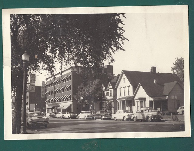
Fourteenth Street in 1954, by then considered part of Corktown.
The Historic Districts
When Corktown was listed on the National Register of Historic Places (NRHP) on July 31, 1978, it only included the part of the neighborhood east of Rosa Parks Boulevard:

Corktown Historic District, as described in National Register of Historic Places Inventory.
When Corktown preservationists fought for a city-recognized historic district (which offers more protection against demolition than the national designation), they attempted to include several blocks between Vermont and Fourteenth Streets. The local historic district was approved on December 24, 1984, but like the NRHP designation, it went no further than Rosa Parks Blvd. In fact, the two districts are nearly idenetical. Then-mayor Coleman A. Young stated that the western part of Corktown was of "dubious historic value" and castigated preservationists for "reckless designation of historic buildings and areas."

Note that in the map shown above, Michigan Central Station was considered to be part of Corktown by that point (early 1985). The train station was also a stop on the very first Corktown Historic Homes Tour in 1987. That same year, when the Corktown Citizens' District Council placed those now-familiar "Corktown: Detroit's Oldest Neighborhood" signs throughout the area, one was placed as far west as 16th Street and Michigan Avenue.
Corktown's so-called "western annex" finally won local historic designation on September 25, 1998. The Corktown Historic District, as now defined by the Detroit Historic Commission, is illustrated below:

The Corktown Historic District as recognized by the Detroit Historic Commission.
A New Definition
Obviously there is no one correct demarcation of Corktown. But it is worth attempting to create a definition that leaves room for interpretation while being restrictive enough to be meaningful: Corktown is the area west of downtown Detroit marked by a more or less continuous population of pre-World War I structures including Most Holy Trinity Church. Under this definition, today's Corktown is represented in the illustration below by the blue and green areas:

Click the image for a larger version.
Whether the areas in the yellow-shaded portion of this map should be considered part of Corktown is a matter of personal opinion. The north side has been separated from the core of the original neighborhood by freeways and parking lots, and like its southern neighbor, has expanded westward. Referring to this area as "North Corktown" seems to be a reasonable compromise that acknowledges its historical connection to Corktown as well as distinguishes its own unique character.
On the south side, every Victorian building within the West Side Industrial District was wiped clean off the map in the mid-1950s. Only the streets remain, and even those have been altered. However, if someone claims that Le Petit Zinc at 1055 Trumbull is located in Corktown, it would seem pedantic to disagree with them.
Finally, that brings us to "Corktown Shores", the name given to the area surrounding the revamped Green Dot Stables restaurant at the corner of Lafayette and Fourteenth Street. I'm pretty sure those guys were just kidding.