
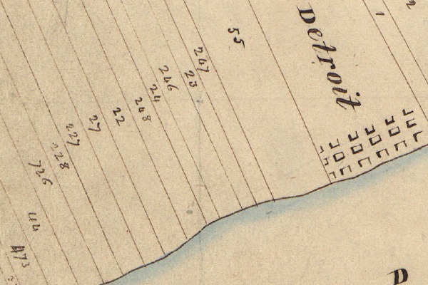
Detail from the U.S. Government's 1818 survey of the Michigan Territory.
Farms were established by Fort Pontchartrain du Détroit very soon after its founding in order to ensure its prosperity. The long, narrow plots that were laid out according to French custom have come to be known as "ribbon farms". This method granted river access to each landowner and allowed the farmers' homes to be relatively close together. The houses sat along River Road, later known as Woodbridge Street and Jefferson Avenue. Behind the house, a typical ribbon farm would contain a garden, fruit orchards, fields of wheat or corn, pasture, and finally woodland.
Over the course of 300 years, what was once farm lots has ultimately transformed into the neighborhood we know today:
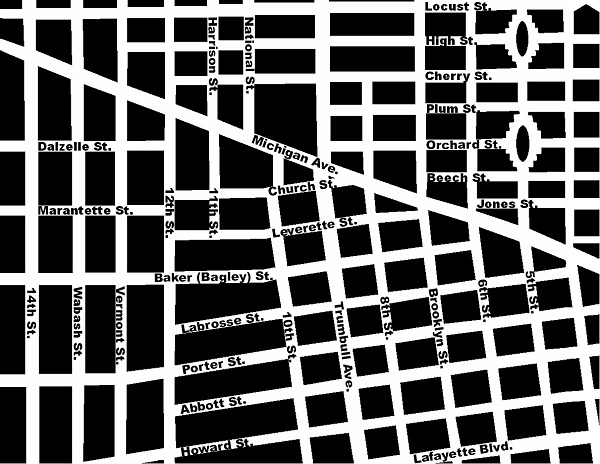
Corktown has been shaped by a combination of the ribbon farm boundaries and Augustus Woodward's plan for Detroit. To illustrate this, it's easier to use a map of the neighborhood from 100 years ago, before urban renewal erased huge swaths the original street grid:
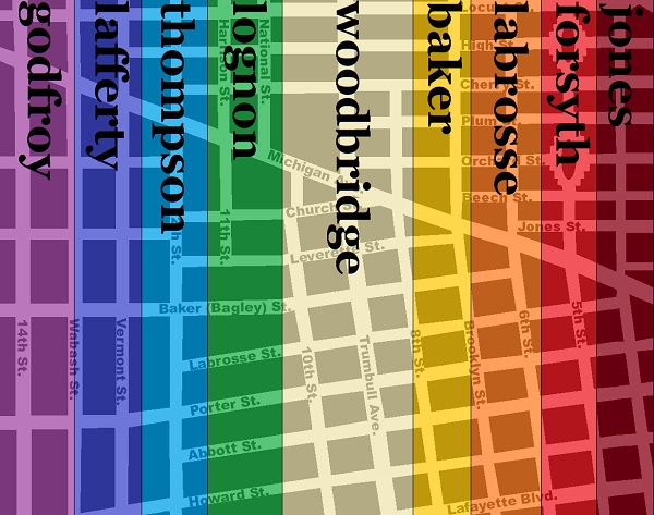
Below is a map showing the outlines of the ribbon farms of Corktown, using the names they would have been known by at the time they were subdivided:
French and British Rule
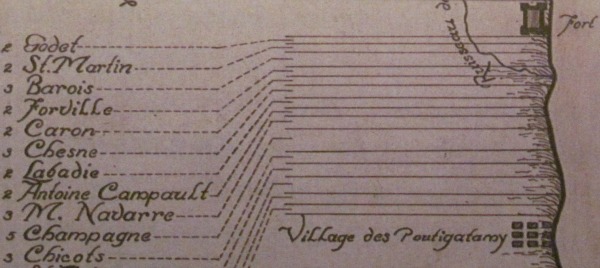
Corktown's ribbon farms as they were in 1749, although there appears
to be a missing farm between "M. Navarre" and "Champagne".
Hickman, C.E. Carte de La Riviere du detroit depuis le Lac Erie jus'ques au Lac Ste Claire [map]. In: Dunnigan, Brian L. Frontier Metropolis: Picturing Early Detroit, 1701-1838. Detroit: Wayne State University Press, 2001, p. 106.
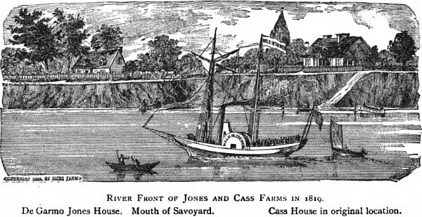
The government of New France granted farmland to settlers at Detroit, but first only east of Fort Pontchartrain. The Hurons--one of several tribes invited by Cadillac to settle at Detroit--had established a village just west of the fort, at the mouth of the Savoyard Creek. By the 1740s, the Hurons had abandoned their settlement and land concessions to French farmers were made west of the fort thereafter.
The British took over Detroit on November 29, 1760 during French and Indian War. In order to prevent conflicts with the American Indians, the British expressly forbade settlement west of the Appalachians in 1763. Although the land was officially an Indian reserve, the private ownership of the farms along the Detroit River did not appear to be disrupted.
The Quebec Act, passed by the British government in 1774, expanded the southern border of the Province of Quebec to the Ohio River, reinstated French civil law among the inhabitants and granted religious liberties to Roman Catholics. This infuriated the overwhelmingly anti-Catholic American Colonies, who considered this law one of the "Intolerable Acts" that would spur the American Revolution. The colonists' war with Britain ended in 1783 with the Treaty of Paris, but no American Indian tribes were a party in that agreement. General "Mad Anthony" Wayne's victory over the Western Confederacy at the Battle of Fallen Timbers in 1794 led to the Treaty of Greenville, signed August 3, 1795, in which all Indian claims within six miles of the Detroit River were given up. The Jay Treaty of 1794 established the boundary between the new United States and Canada, and Detroit was formally ceded to the United States on July 11, 1796.
A New Government
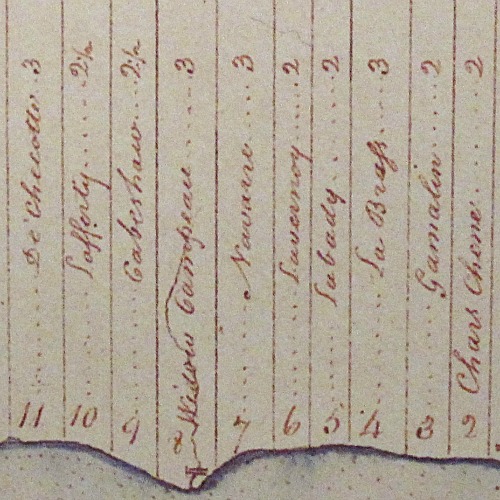
Corktown's ribbon farms in August 1796.
McNiff, Patrick. A Plan of the Settlements at Detroit and Its Vicinity [map]. In: Dunnigan, Brian L. Frontier Metropolis: Picturing Early Detroit, 1701-1838. Detroit: Wayne State University Press, 2001, p. 106.
In 1804, the U.S. government set up an office in Detroit to sell Federal land in the territory, as well as to allow those who already held property to obtain legal recognition of their ownership. Claimants had to show that they had occupied and improved the land prior to July 1, 1796. All claims filed received "private claim" numbers, which remain associated with the parcels today. If the land commissioners were satisfied with the claims, they forwarded the documents to Washington, D.C. for final approval. The owner later received a land patent signed on behalf of the President of the United States "granting" the property to the claimant.
A sketch of the ownership history of each farm follows.
Jones Farm
Width: 2 French arpents (approximately 384 ft)
Area: 68.51 acres (according to first U.S. survey)
Earliest known owner: Pierre Tetard Forville
- 1 April 1750--New France confirmed land grant to Pierre Forville.
- 3 July 1769--The farm was transferred to Charles and Josephe Chene according to Forville's will.
- 1805--Charles Chene died, leaving the farm to his three sons, Pierre, Toussaint, and Gabriel.
- 9 July 1806--Sold to Antoine Lasselle Jr.
- 21 July 1808--Detroit land office recorded private claim #247 by Lasselle.
- 24 July 1810--Sold to James May.
- 30 May 1811--Private claim #247 confirmed.
- 19 May 1814--Sold to Louis Loignon.
- 15 June 1821--Loignon exchanged his land with that of DeGarmo Jones.
- 14 November 1846--Jones died, leaving his widow Catherine as the sole owner.
- 1850s--Catherine H. Jones subdivided the farm and sold it off in parcels.
(Source.)
Forsyth Farm
Width:2 arpents (384 ft)
Area: 66.71 acres
Earliest known owner: Vital Caron (1702-1747)
- 1 April 1750--Government of New France confirmed land claim to "the widow of Vital Caron" (i.e., Magdelene Pruneau Caron).
- ?--The farm came to be owned by Laurent Gamelin.
- 1771--Gamelin died, leaving the farm to his widow, Josette.
- 29 September 1784--"Due to differences" with her eldest son Joseph, Josette Gamelin revoked his right to inheritance and appointed another son, Francois, administrator of the estate.
- 15 October 1784--Josette Gamelin removed son Joseph from the premises "for conduct and mismanagement of the estate".
- 1803--Josette Gamelin died, leaving the farm to Francois Gamelin.
- 16 July 1807--Detroit land office recorded private claim #23 by Gamelin.
- 20 April 1811--Private claim #23 confirmed.
- 15 May 1818--Sold to Philip Lecuyer.
- 19 September 1826--Sold to Augustus S. Porter of New York, who moved to Detroit soon after.
- 15 June 1829--Sold to Robert Allen Forsyth.
- 9 January 1836--Portion of farm between Michigan Avenue and Grand River Avenue sold to a group of investors (Oliver Newberry, Shubael Conant, Elon Farnsworth, Henry Cole, Charles Trowbridge).
- 24 February 1836--Plat of farm south of Michigan Avenue submitted to Wayne County.
- 1843--The owners of the north portion of the farm lost the land to foreclosure, leaving mortgagor William Dwight as the new owner.
- 1 November 1849--North portion sold to Francis Crawford, Albert Crane, and William Wesson.
- 28 December 1850--Plat of north portion submitted to Wayne County.
Labrosse Farm
Width: 3 arpents (575 ft)
Area: 97.77 acres
Earliest known owner: A member of the Chesne (Chene) family, according to a 1749 map.
- c. 1775--Came to be owned by Dominique Jourdain dit Labrosse, according to land patent application.
- 21 July 1808--Detroit land office recorded private claim #246 by Labrose.
- 24 July 1811--Private claim #246 confirmed.
- December 1808--Dominique and Jeanette Labrosse, who had no children, sold the farm to Josette Berthelet on the condition that they would be cared for until their deaths.
- 17 November 1816--Dominique Labrosse died, leaving Josette Berthelet as the owner. (Jeanette Labrosse had died in 1814.)
- 20 June 1833--Sold to Lucius Abbott and Joshua Howard (hence Abbott and Howard Streets).
- 1835--Abbott and Howard sold interest in the land to Charles Trowbridge and John Mullett. Mullett was the surveyor who drew a plat for the land and submitted it to the county the following year.
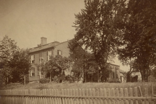
Surveyor John Mullett lived in this house on the River Road between
7th and 8th Streets after purchasing part of the land in the 1830s.
Courtesy Burton Historical Collection, Detroit Public Library.
Baker Farm
Width:2 arpents (384 ft)
Area: 67.37 acres
Earliest known owner: Pierre Descomps Labadie (1702-1782)
- 1 April 1750--Government of New France confirmed land claim of Pierre Descomps Labadie.
- 1782--Labadie died, leaving land to son Alexis Descomps Labadie.
- 16 July 1807--Detroit land office recorded private claim #24 by Labadie.
- 20 April 1811--Private claim #24 confirmed.
- 4 April 1816--Sold to Labadie's son-in-law and daughter, Louis and Cecile LeDuc.
- 25 March 1822--Sold to Robert A. Forsyth.
- 16 December 1823--Sold to Colonel Daniel Baker of the U.S. Army.
- October 1836--Baker submitted a plat of his farm south of Michigan Avenue several days before his death.
- 1845--Executors of Baker's estate prepared a plat for the north portion of the farm.
Woodbridge Farm
Width: 2 arpents (384 ft)
Area: 135.19 acres
Earliest known owner: Antoine Campault (Campau)
- 1 April 1750--New France confirmed land grant to Antoine Campault (Campau).
- 1796--A map from this year indicates the farm was owned by Joseph Livernois.
- 27 March 1806--Sold to Jacques and Francois Lasselle.
- 21 July 1808--Detroit land office recorded private claim #248 by Jacques and Francois Lasselle.
- 30 May 1811--Private claim #248 confirmed.
- 27 November 1816--Francois Lasselle and heirs of Jacques Lasselle sold the farm to Daniel and Margaret Sutherland.
- 1 July 1819--Sold to William Woodbridge.
Width: 3 arpents (575 ft)
Area: 102.53 acres
Earliest known owner: Robert Navarre (1709-1791)
- 1 May 1747--New France confirmed land grant to Robert Navarre.
- 21 November 1791--Robert Navarre died, leaving the farm to his son Francois.
- 12 September 1797--Francois Navarre sold the land to his cousin Joseph Beaubien.
- 16 July 1807--Detroit land office recorded private claim #22 by Beaubien.
- 20 April 1811--Private claim #22 confirmed.
- 15 November 1810--Sold to James May.
- 1 October 1819--Sold to William Woodbridge. Platting began in 1858 and was continued by his heirs.
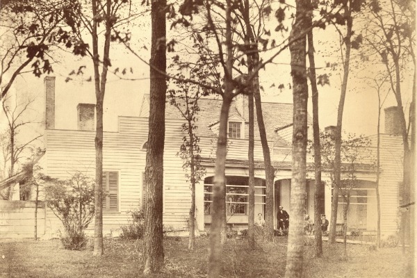
The home of William Woodbridge, on what is now Jefferson Ave., west of Tenth Street.
Courtesy Burton Historical Collection, Detroit Public Library.
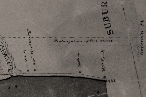
Detail from an 1841 map of Springwells Township showing the location of the Woodbridge
residence. Detroit's western border coincided with Seventh/Brooklyn Street at the time.
Courtesy Burton Historical Collection, Detroit Public Library.
Lognon Farm
Width: 3 arpents (575 ft)
Area: 104.20 acres
Earliest known owner: Antoine Robert, according to Silas Farmer.
- 1 April 1750--New France confirmed grant to Antoine Robert.
- ?--A map of Detroit in 1765 indicates that this farm was owned by Claude Campau.
- 1 February 1798--Claude Campau's widow, Catherine, sold the farm to James May.
- 16 October 1800--Sold the farm to Jacques Peltier.
- 18 July 1807--Detroit land office recorded private claim #27 by Peltier.
- 6 December 1811--Sold to James Henry.
- 3 July 1812--Private claim #27 confirmed.
- 19 July 1819--Thomas and David Gwynne purchased the farm from Solomon Sibley, the administrator of the estate of James Henry, who had recently passed away.
- 3 October 1820--Sold to DeGarmo Jones.
- 15 June 1821--DeGarmo Jones exchanged land with Louis Loignon, which was later spelled "Lognon".
- 1823--Lognon died, leaving behind four minor children: Louis, Gilbert, Lucy and Moses. The property was divided and sold in large pieces before being subdivided into individual building lots.
Thompson Farm
Width: 2½ arpents (480 ft)
Area: 156.54 acres
Earliest known owner: Claude L'esprit dit Champagne*
*The Thompson and Lafferty farms were originally one farm under Champagne.
- 1 April 1750--New France confirmed land grant to Claude L'esprit dit Champagne, who died around the same time.
- 1752--Champagne's widow, Angelique, married Joseph Cabacier. This half of his farm would ultimately become his property. The other half became the property of Angelique's daughter from her first marriage.
- 1796--Joseph Cabacier died several years after Angelique. The farm ultimately became the property of one of their children, Charles Cabacier.
- 12 July 1808--Detroit land office recorded private claim #227 by Charles Cabacier.
- 1 June 1811--Private claim #227 confirmed.
- 26 October 1832--Charles Cabacier had died by this time, and his heirs sold the farm to David Thompson.
- 1850s--Farm was platted.
According to Friend Palmer's book Early Days in Detroit, David Thompson fell in love with the daughter of a widow who operated a hotel at the foot of his property on the River Road and married her. Years later a circa-1890s newspaper story about the abandoned houses along River Road reproduced this sketch of what appears to be that same hotel. By that time it was dilapidated and occupied by a woman and her teenage daughter who were squatting there.
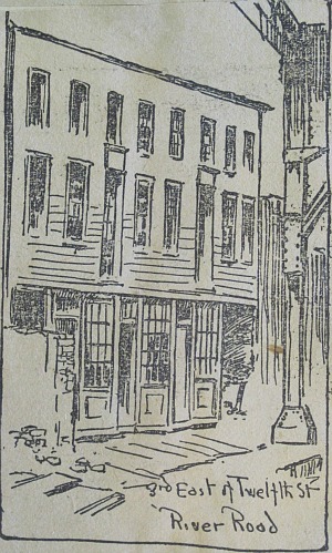
Courtesy Burton Historical Collection, Detroit Public Library.
Lafferty Farm
Width: 2½ arpents (480 ft)
Area: 184.14 acres
Earliest known owner: Claude L'esprit dit Champagne*
*The Thompson and Lafferty farms were originally one farm under Champagne.
- 1 April 1750--New France confirmed land grant to Claude L'esprit dit Champagne.
- c. 1750--Champagne died, and this half of the farm would ultimately become the property of his daughter, Catherine.
- 1771--Catherine L'esprit dit Champagne married Louis Vesiere dit Laferte (Lafferty).
- 5 November 1805--Sold to son Joseph Lafferty.
- 12 July 1808--Detroit land office recorded private claim #228 by Louis Lafferty.
- 1 June 1811--Private claim #228 confirmed.
- 1826--Joseph Lafferty died, leaving the land to his widow, Marie Louise.
- 30 November 1846--Marie Louise Lafferty divided the farm among her three children: Clement, Alexander, and Petronel.
- 1854-1872--Farm was subdivided by the heirs of Joseph and Marie Lafferty.
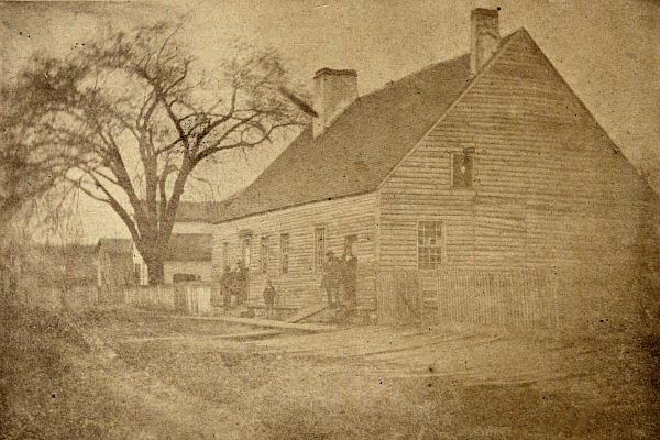
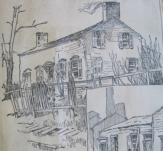
Peter Lafferty House on the river between 12th and 13th Streets in 1860.
The Laffertys' elm tree was a distinguishing characteristic of the shoreline.
Courtesy Burton Historical Collection, Detroit Public Library.
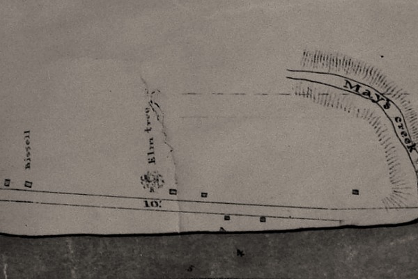
Detail from an 1841 map of Springwells Township. Note the Laffertys' elm tree.
Courtesy Burton Historical Collection, Detroit Public Library.
Godfroy Farm
Width: 3 arpents (575 ft)
Area: 96.68 acres
Earliest known owner: Zacharie Cicotte (1709-1775)
- 1 April 1750--New France confirmed land grant to Zacharie Cicotte.
- 1775--Zacharie Cicotte died, leaving the farm to his widow, Angelique.
- 1791--Angelique Cicotte died, leaving the farm to her son, Jean Baptiste Cicotte. Jean Baptiste then died at an unknown date, leaving the farm to his widow, also named Angelique.
- 24 December 1810--Detroit land office recorded private claim #726 by Angelique Cicotte and her children.
- 10 July 1811--Private claim #726 confirmed.
- c. 1820s--The farm was divided among the children of Angelique Cicotte, which were all purchased over time by Peter Godfroy.
- 1848--Peter Godfroy died, leaving the farm to his widow, Marianne.
- 1864-1875--The farm was platted and sold off.
The "Godfroy Mansion" was built in the 1820s where the foot of 14th Street
would be. It had deteriorated badly by the time this sketch appeared in an
1890s newspaper article. It was finally destroyed by fire in 1894.
Courtesy Burton Historical Collection, Detroit Public Library.
Friend Palmer's book Early Days in Detroit describes what one would have seen walking along the River Road from the Godfroy farm toward the city in the 1830s.
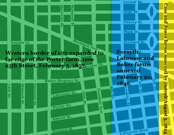
Annexation
All of Corktown used to lie in Springwells Township, which was annexed by the City of Detroit in stages. The Jones farm became part of the city in 1824. In 1849, the city limits were extended to the border between the Baker and Woodbridge farms. The rest of the neighborhood was annexed eight years later.
Streets and Subdivisions
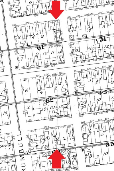
Corktown was not evenly developed from east to west. Portions of the Forsyth and Labrosse farms south of Michigan Avenue were the first to be subdivided in 1835. At the time, they were still part of Springwells Township. This map was published soon after the platting:
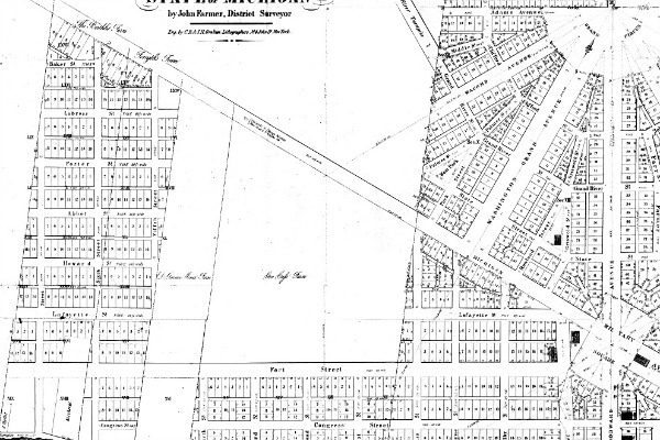 Detail from an 1835 map of Detroit and the surrounding area. (Source.)
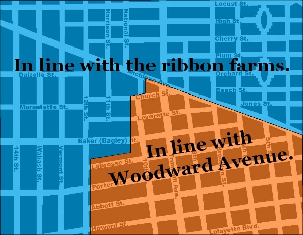
At first, streets were laid out in a neat grid in line with Fort Street and Woodward Avenue without any regard to the borders of the ribbon farms. Since not all farms were platted at once, this resulted in many small, oddly-shaped lots along the old farm borders.
The border between the Woodbridge and Baker farms near Abbott
and Howard Streets. Baker's farm was platted in 1836, but this
part of the Woodbridge farm was an orchard through the 1850s.
This disruptive pattern was finally abandoned after the platting of the Woodbridge farm. This change is evident in the sudden bend in some streets on the border between the Woodbridge and Lognon farms.
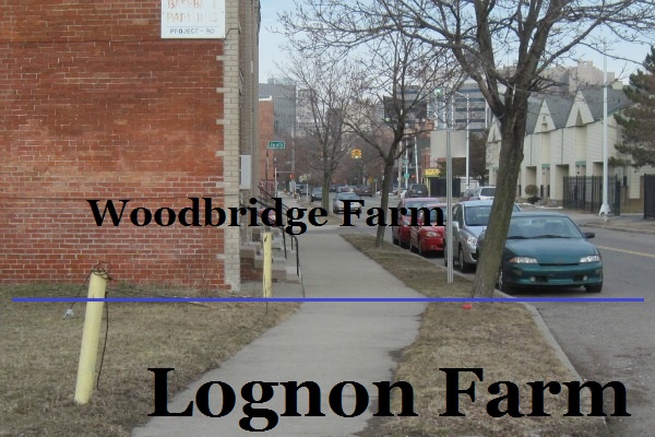
The sidewalk on Bagley Street just west of Tenth Street.
Subdivision Plats
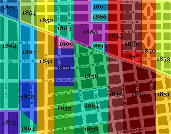
When a land owner wanted to divide their property into lots, they had to work through the City of Detroit, which was responsible for building and planning new roads; and Wayne County, whose approval was required before property can be divided. Normally the land owner(s) would draw up a plat with the assistance of the city surveyor and then submit it to the county. Below is a map of Corktown indicating when each subdivision was platted. Click on a subdivision to see a copy of the original plat on the State of Michigan's website. (A Java update may be required.) Note that many subdivisions have been altered since their original inception. This map is color-coded so that the oldest plats are in red, and subsequent divisions are represented by colors further along the color spectrum.
CLICK ON SUBDIVISION TO SEE ORIGINAL PLAT IMAGE
Although the dates of the subdivisions give a rough idea of the progress of development, the construction of public roads does not necessarily coincide exactly with the subdivision of the land. A long time may pass between platting and road construction--conversely, some of the farms had a few of these streets running through them before the property was divided.
When was Corktown "Founded"?
It is often said that Corktown was "founded" in 1834, presumably because of the signs that were posted throughout the neighborhood in 1988.
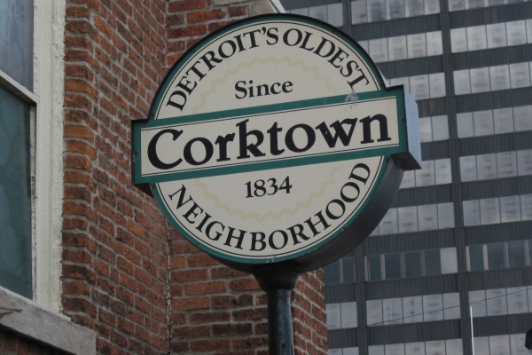
However, it is not known why this year is indicated. The earliest platting was submitted in 1835. No Detroiters listed in the 1837 city directory has a Corktown address. Detroit's population was booming in the 1830s, and immigrants certainly populated Corktown very soon after that directory was published.
The parish of Most Holy Trinity was organized in 1834, but it was originally located downtown and not moved to the corner of Sixth and Porter until 1849--the same year that the core of the neighborhood became part of the city of Detroit.
Whether the designer of these signs had the platting or the founding of Holy Trinity in mind, they were only off by one year.
Wonderful post, full of detail about early Detroit. I'm related to many of the families mentioned above so I really appreciate the information about our heritage! Thank you!
ReplyDeleteWhere did the Chauvins live?
ReplyDeleteThere may have been several Chauvin families in early Detroit, so I can't be sure which one you're referring to. However, in Silas Farmer's history of Detroit, he mentions that the Mullett farm (private claim 182) was originally owned by "M. Chauvin". That farm was approximately between Rivard and Russell Streets and ran from the river up to one mile inland.
DeleteHere is a link to the Dearborn Historian which has an article on the Chauvin Family Cemetery. It will give info on their farm location too, and other info. https://share.google/sLsCBDgFSJpANG6WB
DeleteWhat an exciting post. I am always looking for anything about historic Detroit or better yet, the Michigan Ave corridor. I have ancestors that were in Detroit as early as 1822 and many Irish ancestors who settled in Corktown later in the 19th century. Thank you for all your research!!
ReplyDeleteThis was a great find while I was researching Antoine Labadie.
ReplyDeleteTESTIMONY ON HOW I GOT MY LOAN FROM A GENUINE FINANCE COMPANY LAST WEEK Email for immediate response: drbenjaminfinance@gmail.com
ReplyDelete{Dr.Benjamin Scarlet Owen} can also help you with a legit loan offer. He Has also helped some other colleagues of mine. If you need a genuine loan without cost/stress he his the right loan lender to wipe away your financial problems and crisis today. BENJAMIN LOAN FINANCE holds all of the information about how to obtain money quickly and painlessly via WhatsApp +19292227023 Email drbenjaminfinance@gmail.com
How in the world did you get such detail transaction reports on the farms in the area of Corktown. I'd like to get the same for the original ribbon farms all along the Detroit River, especially the reports for the farms of my ancestors, the Compaus (Campault), Labadies, and others (small community, lots of marriages between families of the early settlers).
ReplyDelete