

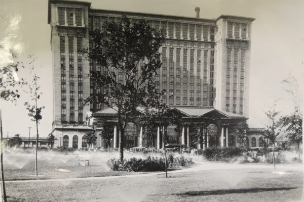
Roosevelt Park circa 1930s.
Courtesy of the Burton Historical Collection, Detroit Public Library.
It's hard to imagine now, but a large group of stores, houses and barns once stood directly in front of Michigan Central Station when it opened in 1913. Roosevelt Park, which was laid out several years later, appropriately created such a grand, formal entry to the building that it now seems as if it had been part of the design all along. The railroad company had in fact simply constructed their train station where it was most convenient for them, along their already existing right-of-way and close to their newly-completed railroad tunnel. The terminal was accessible by both streetcar and automobile, and therefore the owners felt that they had fulfilled their obligation to make it publicly accessible. The construction of parks and boulevards was the city's responsibility.

Michigan Central Station before Roosevelt park.
Photo published in The Detroit Saturday Night, January 30th, 1915.
Image courtesy of Detroiturbex.com.
The idea of establishing some sort of park at this location was discussed when the very first preparations were made at the future depot site. In August of 1910, Wilson Sherman Kinnear, Assistant General Manager of the Michigan Central Railroad, suggested to the Detroit Board of Commerce that "the city co-operate, buy some adjacent property and improve it for park purposes so that persons entering the city may at once have a favorable impression of Detroit," according to the Detroit Free Press.
The City Beautiful

Courtesy of the Burton Historical Collection, Detroit Public Library
By the late 19th century, the industrial progress that led to the growth and success of many cities was also making them increasingly unlivable. Poor planning and a lack of suitable building codes had typically allowed large factories to be built in the midst of crowded and unsanitary residential districts. The City Beautiful movement was an attempt by architects and civil engineers to inspire renewed faith in the American city. This ideology advocated organized civic planning, the construction of classically-inspired public buildings, plentiful parks, and wide boulevards. Two outstanding examples of City Beautiful influence in Detroit are the Detroit Public Library and Detroit Institute of Arts on Woodward Avenue--both marble-clad, Beaux-Arts buildings constructed for public use and peacefully situated amongst beautiful landscaping.
Detroit's City Plan and Improvement Commission was created in 1909 to advise on civic beautification. In October 1911, Charles W. Moore, president of the commission, announced that the city intended to obtain land in front of the future train depot to create a suitable approach to the building. Moore added that the commission would seek the consultation of Chicago architects Daniel H. Burnham and Edward H. Bennett regarding a plan for the site. Burnham and Bennett were among the best-known municipal engineers in the country at the time and ardent supporters of the City Beautiful movement.

From the Detroit Free Press, October 17, 1911.
In February 1912, Burnham and Bennett agreed to draw up a proposal for an approach to Michigan Central Station as well as advise on the expansion of the city's complete parks and boulevards system. Their design was to incorporate elements of Judge Augustus B. Woodward's original plan for Detroit. Burnham died just four months later, but Bennett ultimately finished the job.
Boulevard or Park?
Although city officials agreed that a wide and formal approach to the terminal was necessary, the configuration of the park that exists today was not what anyone had first suggested. Bennett's plan called for a small plaza in front of the train station with a 200-foot-wide boulevard extending toward the intersection of Michigan Avenue and 14th Street. The homes surrounding the boulevard would have been left standing until the property was purchased and redeveloped privately.

Detail from "Union Station Plaza."
Bennett, Edward H., Preliminary Plan of Detroit (Detroit: City Plan and Improvement Commission, 1915)
Later stages of Bennett's plan called for the boulevard to be extended beyond Michigan Avenue toward the current site of the Detroit Public Library and Detroit Institute of Arts. This area, originally known as the Center for Arts and Letters, was only in the conceptual stages at that point. The diagonal street on the lower left of the following illustration would have led directly to Michigan Central Station. The diagonal street on the lower right would have terminated at the (yet-unbuilt) Belle Isle bridge.
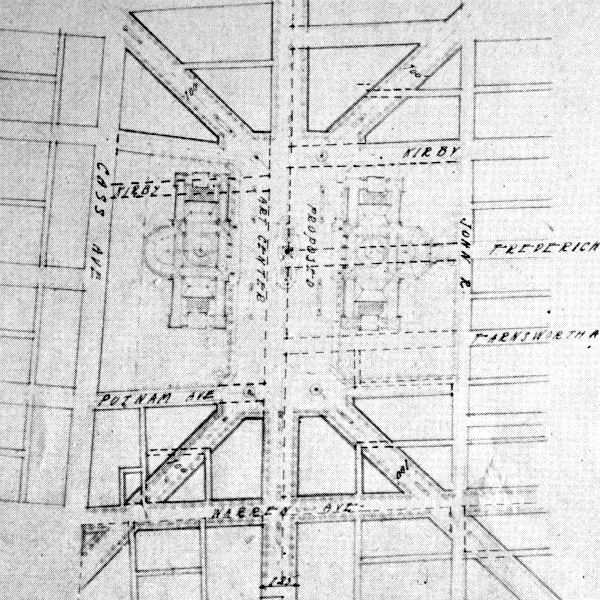
Detail from "Study for the Center of Arts and Letters".
Bennett, Edward H., Preliminary Plan of Detroit (Detroit: City Plan and Improvement Commission, 1915)
The proposed boulevard linking the depot to the Center of Arts and Letters.
Bennett, Edward H., Preliminary Plan of Detroit (Detroit: City Plan and Improvement Commission, 1915)
Not everyone was satisfied with the boulevard concept. On May 15, 1912, business owners from along Michigan Avenue founded the Central Michigan Avenue Improvement Association. Soon after organizing, its members unanimously agreed to call upon the city to condemn the several blocks of houses and business in front of the depot and to lay out a large, expansive park instead. They argued that a new boulevard would have to be paid for by a special tax assessment on local surrounding property, whereas a park could be paid for by general taxation.

The The Detroit Saturday Night, which advocated a boulevard, published
this drawing by architect Edward W. Smith showing the plan's potential.
Image courtesy of Detroiturbex.com.
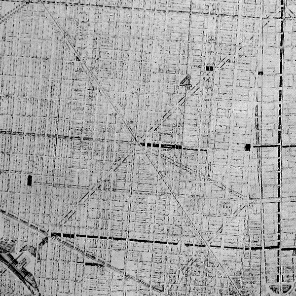
The question of whether to build a park or boulevard would be decided by the City Council. In November of 1912, engineer Frederick Barcroft of the City Plan and Improvement Commission went before the City Council's Committee on Street Openings to outline four possible plans for the depot approach. "Plan No. 1" apparently consisted of the boulevard alone, and "Plan No. 4" called for the large park or esplanade. (I have been unable to find a reference to, let alone a description of, Plans 2 and 3.) The Committee on Street Openings favored Plan No. 4, the most expensive option, but they waited to gauge public opinion on the matter before making an official recommendation to City Council. This plan was soon endorsed by the Central Michigan Avenue Improvement Association.
In February 1913, the Committee on Street Openings switched to favoring Plan No. 1. "Although this plan will leave barns and shanties abutting the boulevard," reported the Free Press, "it will cost much less to effect." The Michigan Central Railroad preferred Plan No. 1, and even offered to cover some of the costs. Meanwhile, the construction on Michigan Central Station progressed rapidly and the houses around it remained untouched.

Michigan Central Station on February 23, 1913. (Source)
Condemnation
In June of 1913, the city filed petitions in Recorder's Court to condemn the property on the future park site. This method was the only way to ensure that all of the parcels could be obtained more or less at once. It was also cheaper, since juries in condemnation suits tended to fix lower prices on land than what could be negotiated with property owners. The case involved a total of 79 parcels of land, which in all contained 100 structures.
Condemnation proceedings began in August and moved very slowly, while the opening of Michigan Central Station came and went on December 27, 1913. The Free Press lamented a month before that Dalzelle street was a "mudhole", and that "visitors arriving in the city over the Michigan Central will be presented with a sorry view of Detroit."
An appeal to the Michigan Supreme Court by property owners early in the condemnation suit held up the process for eight months, but the high court ultimately remanded the case to the lower jurisdiction in June 1914. Due to a backlog of cases to be heard, a jury for the case was not drawn until the following December. Another delay occurred in March 1915, when the city noticed a technical error in its case. Rather than risk losing the case on appeal, the city withdrew and re-filed the case from scratch.
Another jury was drawn in May 1915 and the new proceedings began in June. Businessmen and civic leaders testified that a suitable approach to the new depot was necessary for aesthetic reasons as well as to alleviate the traffic congestion that plagued the vicinity.
On August 6, after two days of deliberation, the jury decided in favor of the city and determined that the compensation due to the owners of the 79 parcels of land would be fixed at $680,519.97. At that time, the city had yet to approve of a final plan for the park.

Illustration from the Detroit Free Press, August 7, 1915.
The Free Press described the sight of the Corktown residents who appeared in court to save their homes from condemnation:
There were many touching little incidents in the proceeding which established a record for time and money involved. Old settlers, some of whom have spent all of their lives in this district, carried their bent forms into court solely on the strength of the fear that the city was about to take their homes away.It would take another two years for the city to finally obtain the titles to all 79 parcels of land. By September of 1917, the structures were still standing and almost all of them were occupied.
They questioned the appraisers and in quavering voices pleaded for a more liberal estimate on the little tract of land that constituted all they had in the world. Assistant Corporation Counsel [Edmund] Atkinson treated them kindly. Many of them knew Judge [William] Connolly, who heard the case, and his father more than 40 years ago.
Some were financially unable to retain the services of an attorney. Judge Connolly gave them all the assistance he could.

The condemned area, from a 1918 real estate atlas.
On September 17, 1917, City Treasurer Max C. Koch auctioned off a portion of the now-city-owned houses. Buyers were only permitted to wreck the houses in order to extract useful building materials, but moving houses off the premises intact was not allowed. The new owners were supposed to have the land cleared within thirty days of the sale.

Forty-five of the 100 houses were sold on the first day. The Detroit Free Press reported:
Strenuous objection to moving has been made by tenants and owners, several owners having gone so far as to refuse to accept the payment allowed them by the courts in the condemnation proceedings. According to information that has reached Mr. Koch, several residents have put in their winter's coal and have announced their determination not to move.The city decided to allow the occupants of the homes to remain until the following April.
The oldest news article I have found that described a park plan that corresponds to what what we have today was printed on December 9, 1917. The Free Press stated that the depot approach "will combine the features of park and boulevard". It was supposed to have been laid out the following year, but budget cuts delayed the work until 1919.
Treasurer Koch held another auction of city-owned houses on April 11, 1918.

In all, the city collected approximately $18,000 from rent and auction proceeds, which was used to grade and level the site. Some of the buildings' new owners continued collecting rent from the occupants without city permission and delayed demolition as long as they could.
A few houses remained unsold, but the city received some free help in clearing them that summer. In June 1918, a "female" (unarmed) Mark IV "Britannia" tank was on display downtown as part of a war savings stamps promotion. The demonstrations of the machine's strength included crushing a limousine and wrecking three of the unsold houses in front of the depot: 311, 315, and 317 Fifteenth Street. The tank, according to a Detroit Free Press reporter,
started to move through the first building as though it were that much card board. After tunneling her way through the first and without even 'coming up for air' she kept on her way of destruction. The second, then the third met the same fate of the first and Britannia stopped only after it was all done still chug-chugging while a crowd of 35,000 interested spectators shouted loudly their approval of this new instrument of war.
The houses were not knocked over. That was not what the tank's penchant is. The British said they were built to go through, and if anyone doubts their success in going through, just take a trip out to the esplanade and see what a Mrs. Tank can do just before dinner time.


The following September, City Council instructed the Department of Parks and Boulevards to "forthwith remove the debris which is all that remains of the old and dilapidated buildings on the site of the new Michigan Central Depot approach, and which being opposite the exact entrance to said depot constitutes a deplorable and unsightly aspect of Detroit to visitors to our city."
Local citizens were evidently eager to begin using this land for recreational purposes, as it contained a temporary ice skating rink during the winter of 1918-1919. It was popular enough that the City Council ordered the Public Lighting Department to provide it with nighttime illumination.
Because the park has been more or less undisturbed since the beginning of the 1920s, it has been discovered to be an invaluable archaeological resource. Although the park has only just begun to be excavated, the artifacts retrieved so far have shown it to be a potential storehouse of information about the Corktowners who lived here between the 1860s and 1910s. Wayne State University archaeologist Tom Killion remarked, "This is an opportunity to look at something that would not otherwise, in most of the rest of Detroit, be available. It's a time capsule."

Artifacts recovered from Roosevelt Park. Photo from archaeology.org,
courtesy of Anthropology Department, Wayne State University.
The Creation of a Park
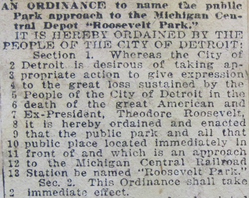
On January 7, 1919, the day after former President of the United States Theodore Roosevelt passed away, the Detroit City Council unanimously passed an ordinance naming the park before Michigan Central Station in his honor.
The ex-president had an opportunity to visit the site of the park that would bear his name long before it received that designation. The Free Press reported his arrival in Detroit in May of 1916:
When Roosevelt stepped out on the esplanade in front of the Michigan Central station, a group of small boys ensconced on the stone railing, yelled "Hullo, Teddy," and evoked the first of the many "Bullys" of the day... Someone had gathered a squad of boy scouts, and as they lined up, the ex-president made to them his first speech of the day. "Boys, be ashamed to do anything mean, be ashamed to be a mollycoddle!"
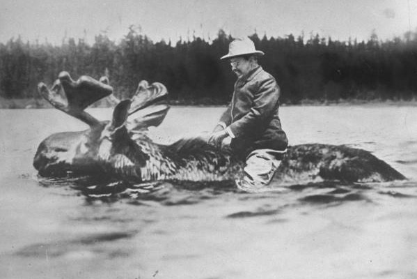
President Theodore Roosevelt. (Source)
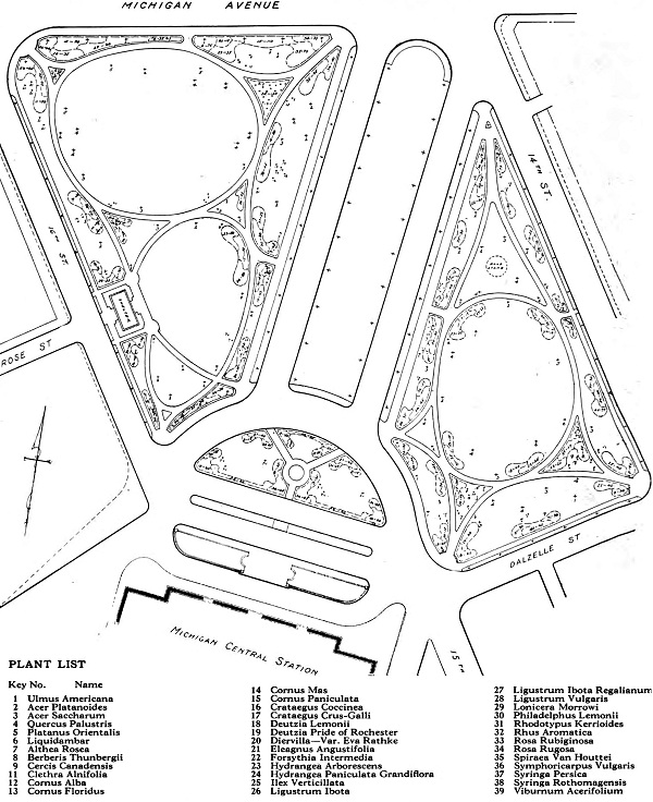
After years of legal, bureaucratic, and financial delays, work on Roosevelt Park began in earnest in 1919. The final design for the park was created by the City Plan Commission. An elaborate planting scheme detailed eleven species of trees and twenty-seven varieties of flowering shrubs that would beautify the landscape.
(Source)
The park's sidewalks were constructed by the Lanyon Cement Construction Company in 1919. The following year, the park lighting conduits were installed and much of the plantings had been laid down. By 1921, the landscaping was complete and a sprinkler system was installed by the John A. Brooks Company, an early pioneer in the field.
Courtesy of the Burton Historical Collection, Detroit Public Library

Courtesy of the Burton Historical Collection, Detroit Public Library
Roosevelt Park complimented Michigan Central Station perfectly. The design accommodated the increased street traffic as well as answered the call to help make Detroit a "city beautiful". The park also provided the public with a place to collectively welcome famous and important visitors, or to bid farewell to soldiers being sent off to war.
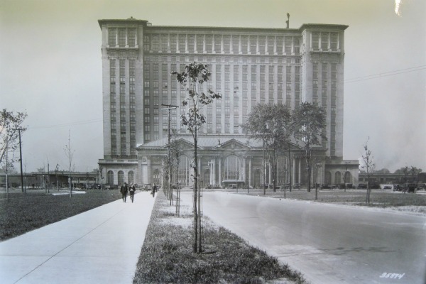
Courtesy of the Burton Historical Collection, Detroit Public Library
Decline and Revival

The park remains city-owned, and at ninety years old it is a bit worse for the wear. The adjacent depot, of course, has been closed since 1988. Few of the trees and shrubs that once comprised a carefully planned landscape remain. An approximately thirty-foot-wide strip of the park was given over to Michigan Avenue when it was widened in the 1930s. The concrete walkways are now mostly overgrown. However, the park still functions as a public gathering space. The Tour De Troit bike ride begins and ends here each year, and attracted 4,300 cyclists at 2011's event.
In 2009, private donors funded the improvement of the traffic island adjacent to the circular drive before the depot with plantings that are of a modern style, but compliment the symmetry and imposing nature of the building.
The following year, a group of business owners and civic leaders organized the Roosevelt Park Conservancy and announced their intention to renew the site as a recreational attraction. The group's plan calls for a complete reorganization of the historic park, including removal of the original walkways and central boulevard. Additions would include "skating elements" (as opposed to a contained skateboarding park), an athletic field and amphitheater.

Courtesy of rooseveltparkrevival.org.

Preliminary plans for "skating elements". Courtesy of rooseveltparkrevival.org.
Any perceived subliminal message is a product of your own dirty imagination.
Roosevelt Park was originally created as the perfect companion to Michigan Central Station. Under the new design, the Beaux-Arts masterpiece that is the park's focal point would be demoted to being a mere "backdrop". The park's historical layout would be replaced by an asymmetrical, modern, and "edgy" scheme. But this isn't the first time that a classically-inspired public space has suffered a modern redesign.
"Nothing Dulls Faster than the Cutting Edge"
Washington Avenue downtown was originally an unimposing, narrow road. When the City Beautiful movement gained popularity, civic planners in 1896 transformed the space into a wide, divided boulevard encircling islands of greenery and renamed it Washington Boulevard. Grand hotels and office buildings replaced the small homes and shops that once lined the street. The boulevard was 200 feet wide--the same width as the one that would run through Roosevelt Park.
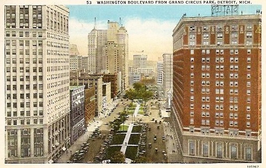
Washington Boulevard, circa 1920s.
In the early 1980s, the city attempted to revitalize Washington Boulevard by replacing the historical layout with an asymmetrical, modern, and "edgy" scheme. The new environment was characterized by installations that locals referred to as "the red monkey bars".

Washington Boulevard in the 1980s.
Courtesy of Walter P. Reuther Library, Wayne State University.
"Detroitblogger John" Carlisle wrote a great post about Washington Boulevard's early 1980s revitalization, which he called a "monstrosity", containing sculptures "depicting things like the artists' agonized rendition of a blob". The new installations, Carlisle wrote, "separate(d) foot traffic from window shopping and blocked the views of the buildings you'd want to see. If the intention was to totally mess up what had been a nice area, the City did a marvelous job."
By the mid-2000s, it was obvious that the hip, modern revamp was an utterly dysfunctional failure. City planners then came up with an excellent idea: they put everything back the way it was.

Washington Boulevard as it appears today.
Courtesy of Outside Partnership Landscape Architecture.
Roosevelt Park unquestionably requires revitalization, but hopefully the lesson of Washington Boulevard will prevent us from making the same mistake in Corktown. If the Roosevelt Park Conservancy completely reconfigures the park and builds an amphitheater, then a neighborhood known for its diversity, history, and quietness will suffer a diminishment of two of those three qualities. I encourage the group to consider arranging the elements of their plan (minus the amphitheater, of course) within the confines of the park's current layout.
There is something almost cynical about eliminating transportation infrastructure (the boulevard) from the site while supporting the city's revitalization. Preliminary steps toward renovating Michigan Central Station began last year, and the building will hopefully be the center of some commercial or civic activity in the future. It makes sense to keep the necessary roads in place to facilitate the flow of traffic around the building when that day comes.
Not everyone shares this view. One of the board members [*correction: recent member] of the Roosevelt Park Conservancy--a Bloomfield Hills resident who just published a book of photographs of dilapidated Detroit buildings--recently told Vogue magazine: "No one should tear these buildings down, but no one should rehabilitate them, either."
I disagree.

Courtesy of the Burton Historical Collection, Detroit Public Library