April 15, 2013

Corktown Pre-History: From Farmland to Development


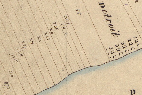
Detail from the U.S. Government's 1818 survey of the Michigan Territory.

Farms were established by Fort Pontchartrain du Détroit very soon after its founding in order to ensure its prosperity. The long, narrow plots that were laid out according to French custom have come to be known as "ribbon farms". This method granted river access to each landowner and allowed the farmers' homes to be relatively close together. The houses sat along River Road, later known as Woodbridge Street and Jefferson Avenue. Behind the house, a typical ribbon farm would contain a garden, fruit orchards, fields of wheat or corn, pasture, and finally woodland.

Over the course of 300 years, what was once farm lots has ultimately transformed into the neighborhood we know today:
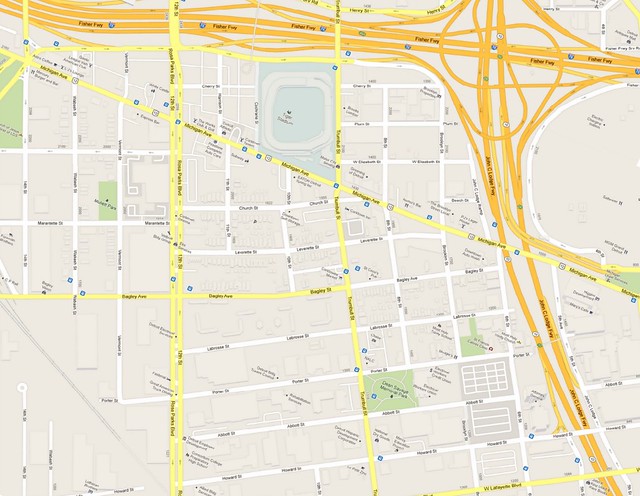

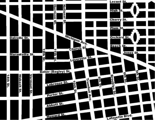
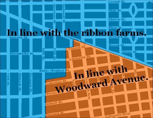
Corktown has been shaped by a combination of the ribbon farm boundaries and Augustus Woodward's plan for Detroit. To illustrate this, it's easier to use a map of the neighborhood from 100 years ago, before urban renewal erased huge swaths the original street grid:

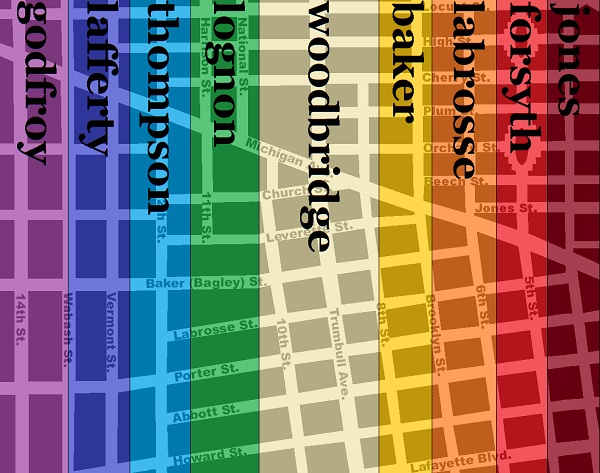
Below is a map showing the outlines of the ribbon farms of Corktown, using the names they would have been known by at the time they were subdivided:


French and British Rule
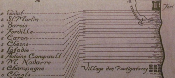


Corktown's ribbon farms as they were in 1749, although there appears
to be a missing farm between "M. Navarre" and "Champagne".
Hickman, C.E. Carte de La Riviere du detroit depuis le Lac Erie jus'ques au Lac Ste Claire [map]. In: Dunnigan, Brian L. Frontier Metropolis: Picturing Early Detroit, 1701-1838. Detroit: Wayne State University Press, 2001, p. 106.

The government of New France granted farmland to settlers at Detroit, but first only east of Fort Pontchartrain. The Hurons--one of several tribes invited by Cadillac to settle at Detroit--had established a village just west of the fort, at the mouth of the Savoyard Creek. By the 1740s, the Hurons had abandoned their settlement and land concessions to French farmers were made west of the fort thereafter.

The British took over Detroit on November 29, 1760 during French and Indian War. In order to prevent conflicts with the American Indians, the British expressly forbade settlement west of the Appalachians in 1763. Although the land was officially an Indian reserve, the private ownership of the farms along the Detroit River did not appear to be disrupted.

The Quebec Act, passed by the British government in 1774, expanded the southern border of the Province of Quebec to the Ohio River, reinstated French civil law among the inhabitants and granted religious liberties to Roman Catholics. This infuriated the overwhelmingly anti-Catholic American Colonies, who considered this law one of the "Intolerable Acts" that would spur the American Revolution. The colonists' war with Britain ended in 1783 with the Treaty of Paris, but no American Indian tribes were a party in that agreement. General "Mad Anthony" Wayne's victory over the Western Confederacy at the Battle of Fallen Timbers in 1794 led to the Treaty of Greenville, signed August 3, 1795, in which all Indian claims within six miles of the Detroit River were given up. The Jay Treaty of 1794 established the boundary between the new United States and Canada, and Detroit was formally ceded to the United States on July 11, 1796.


A New Government
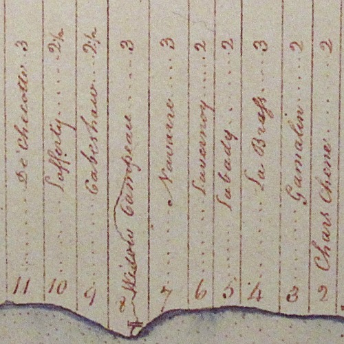


Corktown's ribbon farms in August 1796.
McNiff, Patrick. A Plan of the Settlements at Detroit and Its Vicinity [map]. In: Dunnigan, Brian L. Frontier Metropolis: Picturing Early Detroit, 1701-1838. Detroit: Wayne State University Press, 2001, p. 106.

In 1804, the U.S. government set up an office in Detroit to sell Federal land in the territory, as well as to allow those who already held property to obtain legal recognition of their ownership. Claimants had to show that they had occupied and improved the land prior to July 1, 1796. All claims filed received "private claim" numbers, which remain associated with the parcels today. If the land commissioners were satisfied with the claims, they forwarded the documents to Washington, D.C. for final approval. The owner later received a land patent signed on behalf of the President of the United States "granting" the property to the claimant.

A sketch of the ownership history of each farm follows.


Jones Farm

Private Claim No.: 247
Width: 2 French arpents (approximately 384 ft)
Area: 68.51 acres (according to first U.S. survey)
Earliest known owner: Pierre Tetard Forville
  • 1 April 1750--New France confirmed land grant to Pierre Forville.
  • 3 July 1769--The farm was transferred to Charles and Josephe Chene according to Forville's will.
  • 1805--Charles Chene died, leaving the farm to his three sons, Pierre, Toussaint, and Gabriel.
  • 9 July 1806--Sold to Antoine Lasselle Jr.
  • 21 July 1808--Detroit land office recorded private claim #247 by Lasselle.
  • 24 July 1810--Sold to James May.
  • 30 May 1811--Private claim #247 confirmed.
  • 19 May 1814--Sold to Louis Loignon.
  • 15 June 1821--Loignon exchanged his land with that of DeGarmo Jones.
  • 14 November 1846--Jones died, leaving his widow Catherine as the sole owner.
  • 1850s--Catherine H. Jones subdivided the farm and sold it off in parcels.
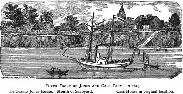

(Source.)


Forsyth Farm

Private Claim No.: 23
Width:2 arpents (384 ft)
Area: 66.71 acres
Earliest known owner: Vital Caron (1702-1747)
  • 1 April 1750--Government of New France confirmed land claim to "the widow of Vital Caron" (i.e., Magdelene Pruneau Caron).
  • ?--The farm came to be owned by Laurent Gamelin.
  • 1771--Gamelin died, leaving the farm to his widow, Josette.
  • 29 September 1784--"Due to differences" with her eldest son Joseph, Josette Gamelin revoked his right to inheritance and appointed another son, Francois, administrator of the estate.
  • 15 October 1784--Josette Gamelin removed son Joseph from the premises "for conduct and mismanagement of the estate".
  • 1803--Josette Gamelin died, leaving the farm to Francois Gamelin.
  • 16 July 1807--Detroit land office recorded private claim #23 by Gamelin.
  • 20 April 1811--Private claim #23 confirmed.
  • 15 May 1818--Sold to Philip Lecuyer.
  • 19 September 1826--Sold to Augustus S. Porter of New York, who moved to Detroit soon after.
  • 15 June 1829--Sold to Robert Allen Forsyth.
  • 9 January 1836--Portion of farm between Michigan Avenue and Grand River Avenue sold to a group of investors (Oliver Newberry, Shubael Conant, Elon Farnsworth, Henry Cole, Charles Trowbridge).
  • 24 February 1836--Plat of farm south of Michigan Avenue submitted to Wayne County.
  • 1843--The owners of the north portion of the farm lost the land to foreclosure, leaving mortgagor William Dwight as the new owner.
  • 1 November 1849--North portion sold to Francis Crawford, Albert Crane, and William Wesson.
  • 28 December 1850--Plat of north portion submitted to Wayne County.


Labrosse Farm

Private Claim No.: 246
Width: 3 arpents (575 ft)
Area: 97.77 acres
Earliest known owner: A member of the Chesne (Chene) family, according to a 1749 map.
  • c. 1775--Came to be owned by Dominique Jourdain dit Labrosse, according to land patent application.
  • 21 July 1808--Detroit land office recorded private claim #246 by Labrose.
  • 24 July 1811--Private claim #246 confirmed.
  • December 1808--Dominique and Jeanette Labrosse, who had no children, sold the farm to Josette Berthelet on the condition that they would be cared for until their deaths.
  • 17 November 1816--Dominique Labrosse died, leaving Josette Berthelet as the owner. (Jeanette Labrosse had died in 1814.)
  • 20 June 1833--Sold to Lucius Abbott and Joshua Howard (hence Abbott and Howard Streets).
  • 1835--Abbott and Howard sold interest in the land to Charles Trowbridge and John Mullett. Mullett was the surveyor who drew a plat for the land and submitted it to the county the following year.
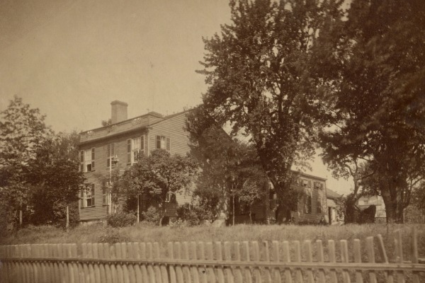

Surveyor John Mullett lived in this house on the River Road between
7th and 8th Streets after purchasing part of the land in the 1830s.
Courtesy Burton Historical Collection, Detroit Public Library.


Baker Farm

Private Claim No.: 24
Width:2 arpents (384 ft)
Area: 67.37 acres
Earliest known owner: Pierre Descomps Labadie (1702-1782)
  • 1 April 1750--Government of New France confirmed land claim of Pierre Descomps Labadie.
  • 1782--Labadie died, leaving land to son Alexis Descomps Labadie.
  • 16 July 1807--Detroit land office recorded private claim #24 by Labadie.
  • 20 April 1811--Private claim #24 confirmed.
  • 4 April 1816--Sold to Labadie's son-in-law and daughter, Louis and Cecile LeDuc.
  • 25 March 1822--Sold to Robert A. Forsyth.
  • 16 December 1823--Sold to Colonel Daniel Baker of the U.S. Army.
  • October 1836--Baker submitted a plat of his farm south of Michigan Avenue several days before his death.
  • 1845--Executors of Baker's estate prepared a plat for the north portion of the farm.


Woodbridge Farm

This area was originally two separate farms.

East half:
Private Claim No.: 248
Width: 2 arpents (384 ft)
Area: 135.19 acres
Earliest known owner: Antoine Campault (Campau)


West half:
Private Claim No.: 22
Width: 3 arpents (575 ft)
Area: 102.53 acres
Earliest known owner: Robert Navarre (1709-1791)
  • 1 May 1747--New France confirmed land grant to Robert Navarre.
  • 21 November 1791--Robert Navarre died, leaving the farm to his son Francois.
  • 12 September 1797--Francois Navarre sold the land to his cousin Joseph Beaubien.
  • 16 July 1807--Detroit land office recorded private claim #22 by Beaubien.
  • 20 April 1811--Private claim #22 confirmed.
  • 15 November 1810--Sold to James May.
  • 1 October 1819--Sold to William Woodbridge. Platting began in 1858 and was continued by his heirs.
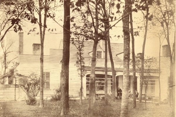

The home of William Woodbridge, on what is now Jefferson Ave., west of Tenth Street.
Courtesy Burton Historical Collection, Detroit Public Library.
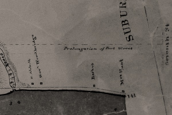

Detail from an 1841 map of Springwells Township showing the location of the Woodbridge
residence. Detroit's western border coincided with Seventh/Brooklyn Street at the time.
Courtesy Burton Historical Collection, Detroit Public Library.


Lognon Farm

Private Claim No.: 27
Width: 3 arpents (575 ft)
Area: 104.20 acres
Earliest known owner: Antoine Robert, according to Silas Farmer.
  • 1 April 1750--New France confirmed grant to Antoine Robert.
  • ?--A map of Detroit in 1765 indicates that this farm was owned by Claude Campau.
  • 1 February 1798--Claude Campau's widow, Catherine, sold the farm to James May.
  • 16 October 1800--Sold the farm to Jacques Peltier.
  • 18 July 1807--Detroit land office recorded private claim #27 by Peltier.
  • 6 December 1811--Sold to James Henry.
  • 3 July 1812--Private claim #27 confirmed.
  • 19 July 1819--Thomas and David Gwynne purchased the farm from Solomon Sibley, the administrator of the estate of James Henry, who had recently passed away.
  • 3 October 1820--Sold to DeGarmo Jones.
  • 15 June 1821--DeGarmo Jones exchanged land with Louis Loignon, which was later spelled "Lognon".
  • 1823--Lognon died, leaving behind four minor children: Louis, Gilbert, Lucy and Moses. The property was divided and sold in large pieces before being subdivided into individual building lots.


Thompson Farm

Private Claim No.: 227
Width: 2½ arpents (480 ft)
Area: 156.54 acres
Earliest known owner: Claude L'esprit dit Champagne*
*The Thompson and Lafferty farms were originally one farm under Champagne.
  • 1 April 1750--New France confirmed land grant to Claude L'esprit dit Champagne, who died around the same time.
  • 1752--Champagne's widow, Angelique, married Joseph Cabacier. This half of his farm would ultimately become his property. The other half became the property of Angelique's daughter from her first marriage.
  • 1796--Joseph Cabacier died several years after Angelique. The farm ultimately became the property of one of their children, Charles Cabacier.
  • 12 July 1808--Detroit land office recorded private claim #227 by Charles Cabacier.
  • 1 June 1811--Private claim #227 confirmed.
  • 26 October 1832--Charles Cabacier had died by this time, and his heirs sold the farm to David Thompson.
  • 1850s--Farm was platted.

According to Friend Palmer's book Early Days in Detroit, David Thompson fell in love with the daughter of a widow who operated a hotel at the foot of his property on the River Road and married her. Years later a circa-1890s newspaper story about the abandoned houses along River Road reproduced this sketch of what appears to be that same hotel. By that time it was dilapidated and occupied by a woman and her teenage daughter who were squatting there.
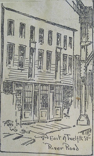

Courtesy Burton Historical Collection, Detroit Public Library.


Lafferty Farm

Private Claim No.: 228
Width: 2½ arpents (480 ft)
Area: 184.14 acres
Earliest known owner: Claude L'esprit dit Champagne*
*The Thompson and Lafferty farms were originally one farm under Champagne.
  • 1 April 1750--New France confirmed land grant to Claude L'esprit dit Champagne.
  • c. 1750--Champagne died, and this half of the farm would ultimately become the property of his daughter, Catherine.
  • 1771--Catherine L'esprit dit Champagne married Louis Vesiere dit Laferte (Lafferty).
  • 5 November 1805--Sold to son Joseph Lafferty.
  • 12 July 1808--Detroit land office recorded private claim #228 by Louis Lafferty.
  • 1 June 1811--Private claim #228 confirmed.
  • 1826--Joseph Lafferty died, leaving the land to his widow, Marie Louise.
  • 30 November 1846--Marie Louise Lafferty divided the farm among her three children: Clement, Alexander, and Petronel.
  • 1854-1872--Farm was subdivided by the heirs of Joseph and Marie Lafferty.
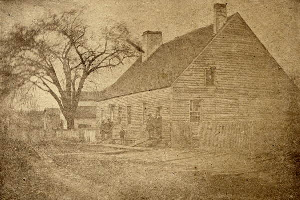

Peter Lafferty House on the river between 12th and 13th Streets in 1860.
The Laffertys' elm tree was a distinguishing characteristic of the shoreline.
Courtesy Burton Historical Collection, Detroit Public Library.
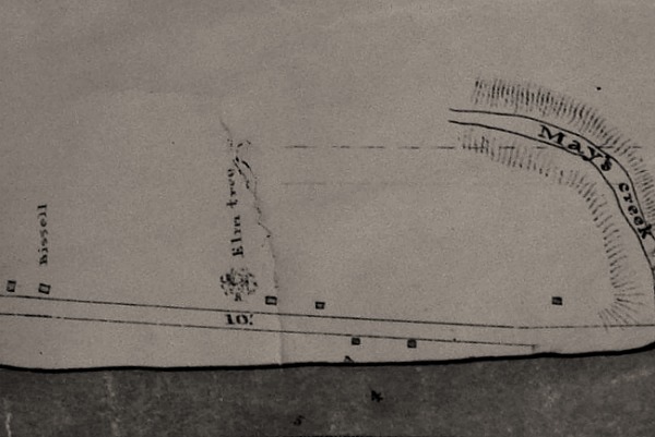

Detail from an 1841 map of Springwells Township. Note the Laffertys' elm tree.
Courtesy Burton Historical Collection, Detroit Public Library.


Godfroy Farm

Private Claim No.: 726
Width: 3 arpents (575 ft)
Area: 96.68 acres
Earliest known owner: Zacharie Cicotte (1709-1775)
  • 1 April 1750--New France confirmed land grant to Zacharie Cicotte.
  • 1775--Zacharie Cicotte died, leaving the farm to his widow, Angelique.
  • 1791--Angelique Cicotte died, leaving the farm to her son, Jean Baptiste Cicotte. Jean Baptiste then died at an unknown date, leaving the farm to his widow, also named Angelique.
  • 24 December 1810--Detroit land office recorded private claim #726 by Angelique Cicotte and her children.
  • 10 July 1811--Private claim #726 confirmed.
  • c. 1820s--The farm was divided among the children of Angelique Cicotte, which were all purchased over time by Peter Godfroy.
  • 1848--Peter Godfroy died, leaving the farm to his widow, Marianne.
  • 1864-1875--The farm was platted and sold off.
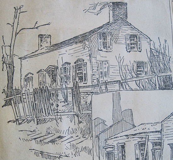


The "Godfroy Mansion" was built in the 1820s where the foot of 14th Street
would be. It had deteriorated badly by the time this sketch appeared in an
1890s newspaper article. It was finally destroyed by fire in 1894.
Courtesy Burton Historical Collection, Detroit Public Library.

Friend Palmer's book Early Days in Detroit describes what one would have seen walking along the River Road from the Godfroy farm toward the city in the 1830s.


Annexation


All of Corktown used to lie in Springwells Township, which was annexed by the City of Detroit in stages. The Jones farm became part of the city in 1824. In 1849, the city limits were extended to the border between the Baker and Woodbridge farms. The rest of the neighborhood was annexed eight years later.
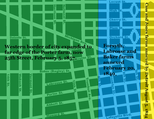


Streets and Subdivisions


Corktown was not evenly developed from east to west. Portions of the Forsyth and Labrosse farms south of Michigan Avenue were the first to be subdivided in 1835. At the time, they were still part of Springwells Township. This map was published soon after the platting:
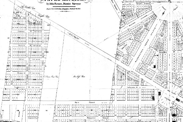
Detail from an 1835 map of Detroit and the surrounding area. (Source.)

At first, streets were laid out in a neat grid in line with Fort Street and Woodward Avenue without any regard to the borders of the ribbon farms. Since not all farms were platted at once, this resulted in many small, oddly-shaped lots along the old farm borders.
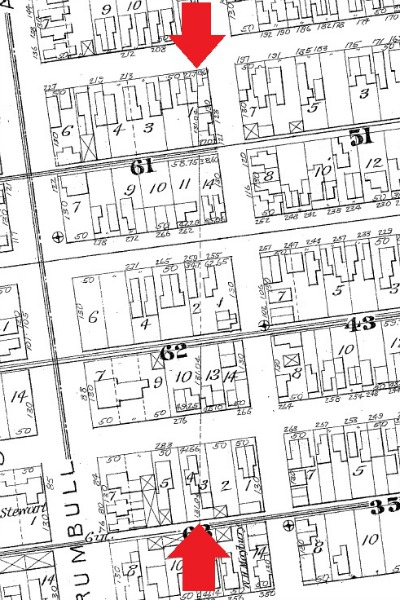

The border between the Woodbridge and Baker farms near Abbott
and Howard Streets. Baker's farm was platted in 1836, but this
part of the Woodbridge farm was an orchard through the 1850s.

This disruptive pattern was finally abandoned after the platting of the Woodbridge farm. This change is evident in the sudden bend in some streets on the border between the Woodbridge and Lognon farms.
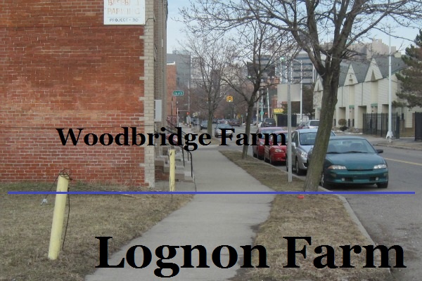

The sidewalk on Bagley Street just west of Tenth Street.


Subdivision Plats


When a land owner wanted to divide their property into lots, they had to work through the City of Detroit, which was responsible for building and planning new roads; and Wayne County, whose approval was required before property can be divided. Normally the land owner(s) would draw up a plat with the assistance of the city surveyor and then submit it to the county. Below is a map of Corktown indicating when each subdivision was platted. Click on a subdivision to see a copy of the original plat on the State of Michigan's website. (A Java update may be required.) Note that many subdivisions have been altered since their original inception. This map is color-coded so that the oldest plats are in red, and subsequent divisions are represented by colors further along the color spectrum.
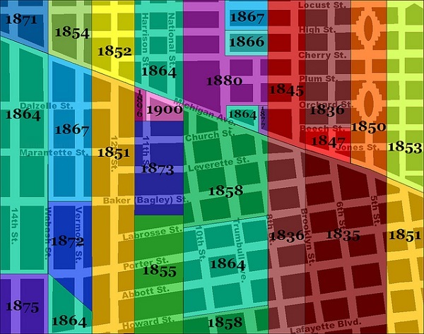

CLICK ON SUBDIVISION TO SEE ORIGINAL PLAT IMAGE
Godfroy 1871Godfroy 1864Godfroy 1875Lafferty 1854Lafferty 1867Lafferty 1872Lafferty 1864Thompson 1852Thompson 1851 (west)Thompson 1851 (east)Lognon 1864Lognon 1896 Lognon 1900Lognon 1873Lognon 1855Woodbridge 1880Woodbridge 1880Woodbridge 1867Woodbridge 1866Woodbridge 1864Woodbridge 1877Woodbridge 1858Woodbridge 1864Woodbridge 1858Baker 1845Baker 1836Labrosse 1836Labrosse 1847Labrosse & Forsyth 1835Forsyth 1850Jones 1853Jones 1851
Although the dates of the subdivisions give a rough idea of the progress of development, the construction of public roads does not necessarily coincide exactly with the subdivision of the land. A long time may pass between platting and road construction--conversely, some of the farms had a few of these streets running through them before the property was divided.


When was Corktown "Founded"?


It is often said that Corktown was "founded" in 1834, presumably because of the signs that were posted throughout the neighborhood in 1988.
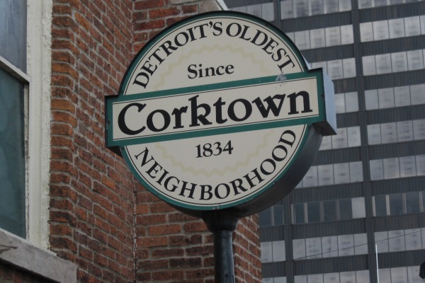

However, it is not known why this year is indicated. The earliest platting was submitted in 1835. No Detroiters listed in the 1837 city directory has a Corktown address. Detroit's population was booming in the 1830s, and immigrants certainly populated Corktown very soon after that directory was published.

The parish of Most Holy Trinity was organized in 1834, but it was originally located downtown and not moved to the corner of Sixth and Porter until 1849--the same year that the core of the neighborhood became part of the city of Detroit.

Whether the designer of these signs had the platting or the founding of Holy Trinity in mind, they were only off by one year.

April 1, 2013

Ancient Streams


Detail from a map of Detroit in 1765 showing the near west side's long-departed streams.
Courtesy Burton Historical Collection, Detroit Public Library.

Once upon a time, a winding creek flowed through the area that would later become Corktown. By the time it was drained and filled over a century ago, it had gone by many names--Campau's Mill Creek, Cabacier's Creek, Peltier's Creek, and May's Creek. It originated in the marshes that used to lie in the vicinity of Grand Circus Park, and from there, flowed southwestward toward the intersection of Howard and Wabash Streets, then turning southeastward through a ravine where it flowed into the Detroit River.

The map below is based on an illustration that appears in Silas Farmer's History of Detroit.


Note that the shoreline of the Detroit River now extends further than it once did. Detroit's once-high riverbanks were graded before the Woodward street plan was implemented, and the excess earth was pushed into the river to create additional land.

Below is a topographic map from 1905, indicating the natural changes in elevation that created the creek.


(Source.)

One of the creek's earliest names was La Riviere du Moulin a Campau, or Campau's Mill Creek. In the early 1730s, settler Charles Campau obtained permission from Detroit's sixth commandant, Louis Henry Deschamps Sieur de Boishebert, to build a grist mill. Campau built a dam and watermill at the north end of the ravine, which would have lied just north of Fort Street.

The damming of the creek would sometimes flood the land to the west of the mill, which in 1753 was the property of Joseph Cabacier. In 1753, Cabacier complained about the flooding and wanted the mill destroyed. Several landowners petitioned the commandant to let the mill stand, stating that it was the only one convenient to the fort and indispensable to the local inhabitants. The petition was forwarded to Michel-Ange Duquesne de Menneville, the Governor of New France, who ordered that the mill be left alone.

The creek was later named Cabacier's Creek, after the adjacent land owner, and eventually May's Creek and Peltier's Creek after subsequent owners of the farm on which the mill was situated.


Detail from an 1841 map of Springwells Township by J. N. Macomb and W. H. Warner.
Courtesy Burton Historical Collection, Detroit Public Library

In 1848, the Michigan Central Rail Road built a depot at the foot of Third Street and laid down tracks on the riverfront leading up to it. The path taken by the railroad took advantage of the existing ravine created by May's Creek where it crossed under Fort Street. These tracks are no longer used, but the outline of the ravine can still be seen south of the Fort Street bridge.


The drainage function of May's Creek was gradually taken over by sewers constructed in the mid-nineteenth century. As the city developed westward, the creek was and filled in and built over. However, the topography that created it can still be observed in Corktown. Looking down Sixth, Brooklyn, Eighth, or Trumbull, one can still observe the ground sloping in toward Labrosse Street, which roughly coincided with the old creek.


Looking north on Eighth Street from Porter, toward the now-departed creek.

Another stream that once flowed near Corktown was the Savoyard River, sometimes also called the Huron Creek. It originated in a swamp that used to be where Lafayette Central Park is today. It ran southwesterly just below Congress Street and flowed into the Detroit River at the foot of Fourth Street. At the beginning of the nineteenth century, the Savoyard was used as a sewage drain by the growing city, and in 1836 the channel was converted into a brick-lined sewer and buried. The Savoyard River is still believed to flow through its underground tomb to this day.

February 25, 2013

Ethel Claes and the West Side Industrial Project

Two important sources deserve special acknowledgement: my neighbor Ann Aldridge, who loaned me her collection newspaper and magazine clippings about Ethel Claes; and the 1962 book Profile of a Metropolis: A Case Book by Robert J. Mowitz and Deil S. Wright, which dedicates a whole chapter to Corktown's urban renewal in the 1950s.

"The Queen of Corktown"


On October 9, 1982, a Detroit Free Press obituary declared, "The Queen of Corktown is dead." Ethel Claes, a Corktown resident for over fifty years and longtime president of its homeowners' organization, had passed away at the age of sixty-nine. The neighborhood--or at least what was left of it--partly owed its existence to the co-owner of a Corktown book shop run out of a Victorian house on the corner of Leverette and 11th Street.

Miss Claes (pronounced "klahs") was born in Duluth, Minnesota on July 24, 1913. Her father Bernard had immigrated from the Netherlands, and her mother Hilja from Finland. After moving to Detroit around 1916, Bernard Cornelius Claes eventually got a job with the Detroit Book Exchange. Having to sell books from his personal collection during hard financial times led ultimately to the opening of his own business, The B.C. Claes Book Shop, by 1930. After four years at 1665 Leverette Street, the family and their book shop moved across the street to their final location, 1670 Leverette. After Bernard's death in 1946, Hilja and Ethel Claes continued to run the book shop, which became well known among rare book collectors throughout the Midwest.


Ethel Claes (right) with her mother Hilja.
(The Detroit News, 22 November 1957)


The Claes Book Shop at 1670 Leverette in 1954.
Note the "BOOK SHOP" sign in the parlor window.


Corktown's Decline


Corktown has historically been an enclave of laborers and immigrants, resulting in a high demand for affordable housing. By the early 1900s, most of the dwellings in the neighborhood were either flats and rented houses. Because there were no zoning laws at the time, commercial buildings cropped up within the residential areas of Corktown. As early as 1917, a publication by the Detroit Police Department described Corktown as consisting primarily of businesses and rental homes:
...the entire district from Sixth Street to Fourteenth Avenue and from Fort Street to Michigan Avenue [is] now occupied by factories and rooming houses ... it is almost impossible to find a private residence, as almost each one is either a boarding house or lodging house, and the transient population here requires close and constant supervision.
By 1937, the Detroit News stated, "Corktown may have crumbled into its own dust as a neighborhood." In 1940, the Detroit City Plan Commission included the area bound by Trumbull, Bagley, Sixth and Howard Streets in a study on urban blight. According to its 1940 Annual Report, it found "ample justification for (its) designation as blighted." Initially, the Commission considered clearing the area for public housing, but the site of the Jeffries Projects was chosen instead. However, the city planners did not forget about Corktown. To paraphrase H.G. Wells, intellects vast and cool and unsympathetic regarded this neighborhood with envious eyes, and slowly and surely drew their plans against it.


The Age of Urban Renewal


With the passage of the Housing Act of 1949, Federal subsidies for slum removal became available to local municipalities. This and similar laws were intended to replace overcrowded, squalid housing with safe and affordable homes, but it carried with it the unintended consequences of the destruction of urban fabric, the clearance of irreplaceable historic structures, and the displacement of poor and minority populations.


July 15, 1949--Pres. Harry S. Truman signs the Housing Act of 1949 into law.

Although the law supposedly addressed a housing shortage, new dwellings did not have to replace leveled slums. New construction only had to comply with the city's master plan. Detroit city planners believed that Corktown, one of the city's "oldest and most blighted residential districts ... cannot be transformed into a good residential area because of its proximity to existing large industry, rail lines, transit terminals (and) other traffic generating activities" (source). Ironically, what is today one of the city's most desirable residential areas was once derided as "unfit for homes" by the City Plan Commission.


A Brave New Neighborhood


Planners' View of Proposed Corktown Industrial Area (1957).
Note Most Holy Trinity Church on the right.
Courtesy Burton Historical Collection, Detroit Public Library.

At the beginning of the 1950s, when Cobo Hall was still in its planning stages, the site was occupied by a busy warehouse and light industrial district. City leaders did not want to lose the displaced businesses to the suburbs, but population and industrialization were at their peak in Detroit and there was little vacant land available within the city limits for their relocation. Corktown, with its convenient access to downtown, the Detroit River, rail terminals, and expressways, was seen as the ideal replacement. The neighborhood was to be rezoned, cleared, and renamed the West Side Industrial District.


A sketch of the gleaming light industrial district adorns the back and
front covers of a 1958 pamphlet promoting the project.
(Source.)

The city wanted to obtain the land in the most efficient way possible--through wholesale condemnation. The area would be cleared and lots would be combined and sold in parcels suitable for commercial use. Utilities would be upgraded and off-street parking requirements would be imposed. All alleys and several streets would be closed. Labrosse and Abbott Streets would be widened to 44 feet in order to serve as trucking thoroughfares, by which the businesses' loading docks would be accessed, while Bagley and Porter Streets would remain 30 feet wide and accommodate regular automobile traffic.


Illustrations from Urban Renewal Notes, March-April 1966. (Source.)

The plan called for multistory office buildings to be constructed along the Lodge Expressway; warehouses and wholesalers to be established between Sixth Street and Trumbull; light industry and trucking terminals between Trumbull and Twelfth Street; and in the middle of it all, "a commercial center to include a hotel for out of town buyers and truck drivers, a cafeteria, small shops and employee meeting rooms" (The Municipal Employee, April 1961). A two-acre site was reserved next to the "commercial center" for a public park to include "landscaped recreation areas with shuffleboard courts, horseshoe pits and benches"--evidently the preferred recreational accommodations of truckers and wholesale buyers.


Quantifying "Blight"


In order to qualify for slum clearance subsidies, Detroit had to prove that Corktown was in fact blighted. City planners chose a 75-acre site which they believed would most likely be approved--between Porter and Lafayette east of Trumbull, and between Bagley and Lafayette west of Trumbull.


Proposed re-zoning for the 75-acre site within Corktown from 1958. (Source.)

How does one define "blight"? Common sense factors such as housing defects and crime rate were considered, but the urban planners of the 1950s used more creativity in interpreting the word. They also included indications such as:
  • The age of buildings
  • The occupants' income
  • "Overcrowding" of buildings
  • Lack of yard space
  • Intrusion of non-residential uses
  • Narrow streets
  • High traffic volume
  • Lack of off-street parking
  • "Mixed character" of buildings

Actual photo from a 1962 urban renewal report by the Detroit City Planning Commission.
The differences in housing styles is supposed to be an example of "blight".
(Source.)


The Neighborhood Fights Back


The city's plan to destroy a large swath of Corktown was obviously controversial among its residents. Although not all homes would be demolished, those left would lose much of their value when suddenly adjacent to an industrial area. Long-time homeowners--especially the elderly whose homes were paid off--were unlikely to find similar housing for the cost of the condemnation awards that they could expect. Many residents resented the city's view of the area as "blighted". They acknowledged that their homes were old in need of repair, but they maintained that upgrades and renovations were superior alternatives to annihilating entire blocks of houses. It was also discovered that some of the littered and overgrown vacant lots were in fact city-owned.

Miss Ethel Claes prepared a petition in protest of the urban renewal project. It was signed by 1,200 Corktowners and delivered to Detroit City Council on January 15, 1951. The City Plan Commission disingenuously replied that the Federal funds that they had received up until that point were not for condemnation, but merely to study "which section should be so redeveloped". City Plan Director George Emery assured Miss Claes that the section where her bookstore was located was "unlikely to be included in the early stages of any redevelopment," and that her property would not be in danger "for some time to come". Miss Claes somehow did not find these words to be very comforting.

When Miss Claes attempted to petition the Federal agency that would ultimately fund the demolition (the Housing and Home Finance Agency, a precursor to the Department of Housing and Urban Development), the petition was returned and she was told that her concerns were a local matter. The Detroit City Council was the only publicly accountable entity that she could appeal to.

In 1951, the Corktown Homeowners' Organization was founded to encourage renovations and neighborhood cleanups so that the neighborhood could not be considered a slum. When the group contacted various public agencies (Board of Health, police, etc.) to inquire about the data that indicated blight (crime, child delinquency, etc.), they could not find any such specific information about the actual project area. By 1953, Miss Claes was president of the Corktown Homeowners' Organization and leading its 1,000 members in the fight for their survival. At first the plan was opposed by various ethnic clubs and other neighborhood groups, but they ultimately united under Miss Claes' leadership.


"The wrath of God will fall on our city."


Also involved in the controversy were the heads of Corktown's two largest religious organizations--Father Clement Kern of Most Holy Trinity Catholic Church, and Reverend John F. Mangrum of St. Peter's Episcopal Church.

Rev. Mangrum, originally from Grand Rapids, received his Masters of Divinity in 1949 and served as rector of a church in Albion before coming to Corktown in 1951. He was outraged by the project's displacement of families and called the plan "un-American". In a letter to the editor of the Detroit Free Press, published February 11, 1954, he wrote, "Destroy families, tear up homes and supplant them with questionable business development and the wrath of God will fall on our city."

Rev. Mangrum was equally blunt in communicating with city officials directly. When he was invited to meet with the Plan Commission about the project, he replied:
It is very good of you to invite me to attend the meeting of the Plan Commission relative to the disposal of the people in Corktown--or should I say the buildings? The city government seems so much more interested in buildings than people!

There are a few reservations that I would like to make. First, that attendance at your little
tête-à-tête will in no wise constitute endorsement of your shop-worn city plan to me. I intend to fight it every inch of the way....

Just know that I am certain the plan for Corktown is evil and bad, and must be beaten completely. The proposed "redevelopment" is not progress, is not just, and is at base a cruel, cruel proposal. I am certain of that.

Reverend John F. Mangrum circa 1964.
Courtesy Burton Historical Collection, Detroit Public Library.

When Rev. Mangrum met with members of the Plan Commission on May 10, 1954, head city planner Francis P. Bennett claimed he was ultimately concerned with the welfare of the citizens of Corktown who live in slum conditions. Rev. Mangrum replied, "You come out here the day they tear down the people's houses and watch their faces and tell me that.... You don't have to live with them. You don't have to go down there. You don't have to watch, to talk, to explain. Statistics to you--that's all."

Rev. Mangrum joined forces with Miss Claes, but Father Kern was not convinced that the project was a bad idea. Having been pastor of Most Holy Trinity since 1943, his parish was the largest in Corktown, consisting primarily Catholic Maltese and Mexican families. Father Kern worked closely with the poor and believed that the project would benefit them, as the government pledged to relocate the 140 displaced families to safe and adequate housing.


Father Clement H. Kern, circa 1950s.
Courtesy Walter Reuther Library, Wayne State University.

In Father Kern's mind, urban renewal was delivering the city's poor to better homes. He cooperated with the government on the West Side Industrial project, even serving on the Plan Commission's Relocation Advisory Committee.


Meetings, Petitions, and a Clean-Up Campaign


The fight for Corktown dragged on for years. Neighbors signed petitions testifying that the crime rate was lower than stated by city council. Several doctors signed affidavits affirming that tuberculosis and other diseases indicative of blight were not present in Corktown. The Corktown Homeowners' Organization coordinated the community's preservation and encouraged property rehabilitation. In order to highlight recent home improvements, posters were made with photographs of houses in the area. Some of these posters have survived, and the images have been scanned and uploaded to Flickr.


1601 Porter.
Stickers that indicate specific upgrades are affixed to some photos.


1419-1425 Abbott.


An updated, modern kitchen at 1377 Abbott.


The garden behind 1730 Labrosse.

Father Clement Kern of Most Holy Trinity advised the Plan Commission that they would have to convince Miss Claes of the necessity of urban renewal in order for the plan to progress without trouble. The Commission met with Miss Claes on May 3, 1954, but it did not go as they had hoped. She criticized them for not holding public hearings regarding their selection of the project site, and drilled them on their justifications for declaring Corktown a slum. They replied that their studies indicated that the area is blighted, but when Miss Claes demanded to know what statistics led them to that conclusion, they replied that the data wasn't available because the studies had not been completed. When she asked why they did not instead help rehabilitate the area if blight was really the problem, planner George Villican replied, "It's not our problem. We merely study problems."

On July 22, 1954, between 400-500 Corktowners packed a public hearing about the project before City Council. Members of the City Plan Commission started the meeting with a presentation of statistics indicating Corktown's blighted condition. They were followed by a dozen Corktowners defending their neighborhood. Miss Claes was the final speaker, and came prepared with statistics countering what had been presented earlier. She pointed out that the information used by the Plan Commission was based on geographic boundaries (e.g., census tracts) that did not coincide with the proposed project area, and that many homes in the area were currently being improved. The Council decided to allow the Plan Commission to issue a detailed report on blight in the neighborhood and to hold an additional hearing in the future.

Nonetheless, Council was satisfied enough with the data that they authorized the renewal plan to be sent to the Housing and Home Finance Agency (HHFA) in March 1955. The following month Miss Claes and Congressman Charles C. Diggs met with the Plan Commission to again refute the allegation that Corktown was a slum. Congressman Diggs was convinced enough to contact the HHFA and relay Miss Claes' concerns. The HHFA in turn contacted the City of Detroit to request better data on the neighborhood's condition, and a parcel-by-parcel survey of the properties in the project area was initiated.

In the meantime, the City Council formally declared the project area to be blighted on June 16, 1955, without a public hearing and while Miss Claes was away from the city. Father Kern and Reverend Mangrum met with Mayor Albert Cobo several days later to plead that the cleared area at least be replaced with new housing instead of industry, in order to preserve the community. The city had always insisted that it was clearing the site to get rid of a slum, not for economic reasons. Mayor Cobo, however, now argued to Rev. Mangrum and Father Kern that the development must be industrial specifically for economic reasons.

Later that year, Rev. Mangrum was reassigned to a church in Palm Beach, Florida, and Miss Claes lost an important ally.


The Final Years


The HHFA approved the city's Corktown renewal plan on January 10, 1956, but Miss Claes and her neighbors fought on. Corktown continued to improve under the guidance of the Corktown Homeowners' Organization, even participating in a neighborhood conservation program organized by the very Plan Commission that wanted to see the neighborhood leveled.

Another public hearing--only the second in three years--was held before City Council on June 28, 1957. Miss Claes spoke, again asserting that Corktown was not a slum by any meaningful criteria. Homes were being fixed up and modernized. Vacant lots were being cleaned up. Properties that remained in bad condition, she pointed out, tended to be owned by slumlords who resided outside of the neighborhood. In her speech, Miss Claes stated:
The public must be disabused that Corktown and skid row are one. In Corktown everybody works hard; there is no panhandling, and no street loafers, and there is no drink problem.... Corktown and the project area is NO SLUM....

It is well known that in the last three years a great improvement has been made in the condition of houses in Corktown. We have held competitions for the best improvements, and a great amount of work has been done on the properties....

[Bringing] property up to code within a stipulated period ... can save the area, can save the city a lot of money, and its inhabitants a lot of grief....
Despite the citizens' efforts, the Detroit City Council voted unanimously in favor of the project site's condemnation on July 10, 1957. In an editorial printed the following day, the Detroit Free Press defended the decision with words that sound ironic today: "...it is of paramount importance that Detroit, its vacant land gone, fully utilize existing space to strengthen its industrial structure."

The formal agreement between the HHFA and City of Detroit was signed in November of 1957. By October 1958, a condemnation jury awarded $1,859,284 to the owners of the 13 commercial properties, 19 multi-housing units, 60 single- and double-family homes, and 18 vacant lots seized by the city. Relocation began immediately and took about a year. By the time the land was cleared, work had already begun on Cobo Hall and the displaced businesses had already relocated elsewhere. Still, the city hoped to attract industry to the area.


"Progress"


Above: Corktown in 1956. Below: The same area in 1961. Images courtesy DTE.


Aerial view of the West Side Industrial District, circa 1966.
Courtesy Burton Historical Collection, Detroit Public Library.


The FTD headquarters at 900 W. Lafayette was one of the first new buildings to occupy
the urban renewal area. (Note Most Holy Trinity Church in the background.)
This building has since been replaced by a Greyhound bus station.
(Photo source.)


The hotel and park at the center of the West Side Industrial District circa 1966.
Courtesy Burton Historical Collection, Detroit Public Library.

The city-planned district called for a hotel to serve truckers and out-of-state wholesale buyers. Across the street was a park named Dean Savage Memorial Park in honor of Dean James Savage (1846-1927), who served all but ten years of his priesthood at Most Holy Trinity. The park was equipped with shuffleboard courts. The hotel, located at 1331 Trumbull, originally operated as the Holiday Inn Downtown.


This mid-1960s postcard from the Holiday Inn Downtown invites us to dine
at The Steak Room, decorated with artificial wood paneling and blood-red
leather-upholstered furniture, "for a memorable dining experience." And why
not unwind after dinner with a relaxing game of shuffleboard?
(Image source.)


Today the hotel is operated as The Corktown Inn. No trucks were spotted in the
parking lot when I visited the premises, and I declined to inquire of the gentlemen
staying there what wholesale commodities they were purchasing.


For the convenience of The Corktown Inn's guests, a vending machine dispenses toiletries, prophylactics, ladies' undergarments, and--in the spirit of Corktown--Irish Spring® soap.
Image courtesy MurderMotels.com.


Architectural Casualties


The buildings previously occupying the project site were photographed before their untimely demise, both by the residents who fought to protect them and by the Plan Commission who declared them to be blighted. The images below credited to the Burton Historical Collection were originally from the Plan Commission's files.


1211 Trumbull.
1950s image courtesy Burton Historical Collection, Detroit Public Library.


1205 Trumbull.
1950s image courtesy Burton Historical Collection, Detroit Public Library.


Convent of the Immaculate Heart, 1051 Porter.
1950s image courtesy Burton Historical Collection, Detroit Public Library.


1216 Howard.


1600 Howard.
1950s image courtesy Burton Historical Collection, Detroit Public Library.


1556 Howard.


1639 Abbott.


1551 Abbott.

labrosse1743
1743 Labrosse.
The older building was Carhartt's headquarters for three years
during the Great Depression after its Michigan Ave. factory closed.
1950s image courtesy Burton Historical Collection, Detroit Public Library.


1525-1531 Bagley.

The building in the modern image above is part of the Clement Kern Gardens subsidized housing project. Despite being cleared for "urgently needed" industrial space, this entire block sat vacant for twenty-five years. This development, designed by Detroit architect Roger Margerum, was constructed in 1985.

Clement Kern Gardens is adorned with a statue of its namesake, Father Clement H. Kern of Most Holy Trinity Church, who died in 1983. The statue was installed by sculptor Edward Chesney in 1986, and it is completely enclosed by a locked, eight-foot-high, wrought iron fence to protect it from the community Father Kern once served.


The Legacy of Ethel Claes


Miss Ethel Claes in 1975.

In the end, Miss Claes failed to stop the bulldozers. Seventy-five acres of the neighborhood were cleared, disbursing hundreds of residents. Property values fell and the blight that everyone had been battling only increased. This had in fact been the planners' intention all along. In Profile of a Metropolis, Mowitz and Wright wrote:
Members of the Plan Commission staff and the Housing Commission staff admitted privately that some of the blocks near the project site were in good condition. A Housing Commission staff member said that he expected the surrounding area to deteriorate once the redevelopment project was completed, and then all of Corktown could be condemned and put to industrial use.
The history of Corktown in the twentieth century is a history of its destruction. Homes and businesses were cleared to construct Michigan Central Station and Roosevelt Park, to widen Michigan Avenue, to build the Lodge and Fisher Freeways, to create the West Side Industrial District, and even for the unforgivably frivolous use of parking the cars of Tiger Stadium patrons. What we call Corktown today is just a small remnant of what there once was. But these few surviving blocks might have withered and died if not for Miss Claes' charismatic leadership, her book shop as a rallying point for the neighborhood, and the Corktown Homeowners' Organization's emphasis on home maintenance.


Hilja and Ethel Claes in 1974.

For the rest of their lives, Ethel Claes and her mother tended their book shop and remained active in neighborhood conservation. As consuming as these tasks were, Miss Claes did find the time for marriage, however briefly. On July 23, 1964, she married Roy Etherton, a Russian-born man 23 years her senior. He passed away just over a year later, on November 16, 1965, at the age of 73. Despite legally becoming Mrs. Etherton, everyone still knew her as "Miss Claes".

* * * * *

By the 1970s, American society began to realize that we no longer created beautiful buildings, and that people needed tangible connections to their cultural past. As a result, the need for historic preservation became evident and Corktown received well-deserved recognition for its collection of 18th century working-class homes. An article on the neighborhood from The Detroit News of January 14, 1979 gushed, "Architecturally, Corktown is a gold mine, a giant toy store for preservationists."

Miss Claes lived to see her neighborhood added to the National Register of Historic Places on July 31, 1978. After her death, the City of Detroit granted Corktown historic protection on December 24, 1984, and added a western annex that included Wabash and Vermont Streets on September 25, 1998.

When Miss Claes passed away in October of 1982, the Detroit Free Press' Louis Cook wrote, "Of all the classic writers of letters to the editor the Free Press has experienced, Miss Claes was one of the most vinegary and brilliant." She was, he added, "imperious, poetic and a lot of fun to be around if your hide was thick enough."

In accordance with Miss Claes' wishes, there was no funeral service. She was survived by her mother, who passed away just five months later. Both were laid to rest in Fernwood Cemetery in Gladstone, a town in Michigan's upper peninsula where Bernard C. Claes was interred in 1946.


The headstone of Ethel Claes Etherton.
Photo courtesy Elaine Ackerman.
(Source.)


Miss Claes' former home and book shop at 1670 Leverette.
Photo by Joseph C. Krause.