November 26, 2012

Detroit Athletic Company


The Detroit Athletic Company has sold Detroit sports memorabilia one block from the former Tiger Stadium site since 1985. Behind the facade's white stucco lie two Victorian-era buildings constructed twelve years apart. Together they originally consisted of three ground-floor commercial spaces with two apartments above. The histories of each of the commercial spaces are detailed separately below.

526 (1740) Michigan Avenue


The east (right) half of the building, originally addressed as 526 Michigan Avenue, was the first to be built.

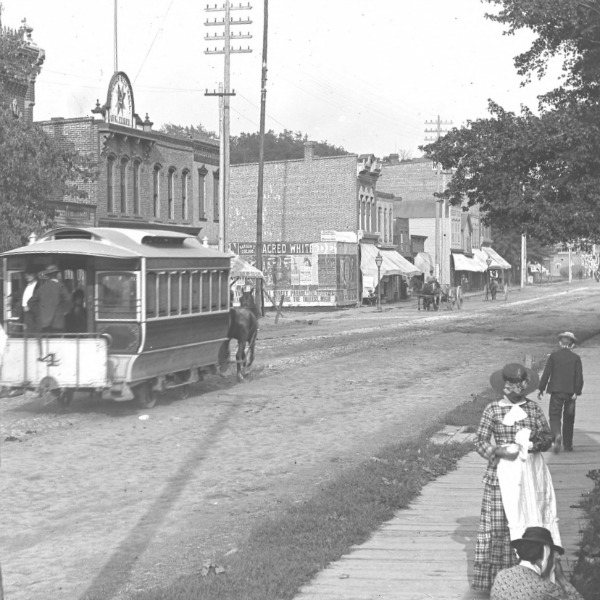
Above: Michigan Avenue west of Harrison, some time between 1881 and 1884. (Courtesy Burton Historical Collection, Detroit Public Library)
Below: The same block as it appears today. The west (left) half of the store
had not yet been built when the 1880s photos was taken.

The permit to construct this building was issued May 24, 1878. The following day the Detroit Free Press noted, "A brick building for a store is to be built at the corner of Harrison and Michigan avenues, the excavation for the cellar having been already made." The owner was Horace M. Dean of the interior decorating firm Deans Brow & Godfrey.

The building almost didn't survive one year. On the night of February 14th, 1879, Frederick Steben of 112 Harrison Avenue saw a fire inside of the store and ran to the Trumbull Avenue police station to sound the fire alarm. Fire Engine Company No. 8 arrived within minutes and extinguished the flames. Police Officer John Martin, who accompanied Steben back to the store, discovered several partially burned piles of wood shavings saturated with kerosene inside, suggesting arson.

Suspicion fell upon the building's tenant, picture framer Alexander M. Kolakosky, whose merchandise on the premises was insured. He was arrested and subsequently examined in Police Court on February 25th and March 7th. Testimony was delivered by Officer Martin, Fire Department Foreman Richard Filban, Fire Marshal George Dunlap, and the building's owner Horace Dean. There was deemed enough evidence to go to trial, and Kolakosky was bound over to Recorder's Court. He was arraigned on April 8th and charged with arson, to which he pleaded not guilty. The trial occurred on May 1st and he was acquitted by the jury. On May 18th, the Free Press noted: "After paying $125 attorneys' fees, and passing three months in jail, A. M. Kalokoski [sic] has settled with the insurance companies for $75."


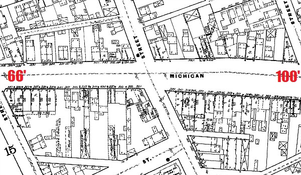
The block that includes 526 Michigan Avenue on the 1884 Sanborn map.


Other known occupants of this address:

1879-1880 Geloramo Cannata, jeweler
1881-1882 William C. Wright, grocer
1883 Job Thomas & Co., grocers (Job Thomas & Alexander W. Slocum)
1884 Alfred G. Stanlake, grocer
1885 Holden & Westaway, grocers (Newton B. Holden & James Westaway)

Newton B. Holden went missing on the night of April 24, 1885, having last been seen crossing the Detroit River in a rowboat. His parents lived in Sandwich (now Windsor), and crossing the river by this means was not uncommon. The boat was recovered from Grassy Island on May 1st, but Holden's body was not discovered until a month later, near Wyandotte. He had evidently drowned, but foul play was ruled out as his coat pockets still contained a large sum of money.

1885-1887 Garrett Cotter, grocer
1888 (Vacant)
1889-1890 Deubel & Voorhees, feed (William H. Deubel & George W. Voorhees)
1891 William S. Gill, harness maker
1892 James F. Walsh, upholsterer
1893 Singer Manufacturing Co., sewing machines

For the next 36 years the space was used as a laundry establishment. In 1894 it was the Star Laundry, operated by Edgar C. Wheeler and Orra D. Pursell. The latter partner left the following year and the business was then run by Edgar C. Wheeler & Son from 1895 to 1905. By 1906 Star Laundry was acquired by Banner Laundry, a large, successful operation that had recently moved to the northwest corner of Brooklyn and Plum Streets, where it would thrive for decades. Their three-story headquarters still stands at 2233 Brooklyn and is now used as inexpensive lofts.

526 Michigan Avenue remained a laundry business until 1930, sometimes being listed as a branch location of Banner Laundry, sometimes as Star Laundry. In 1931 the space was used as storage for the National Upholstery and Furniture House, but after that it was vacant for much of the Great Depression.


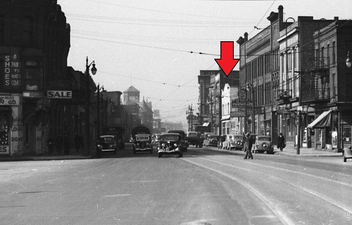
Michigan Avenue between Harrison and Cochrane, probably in the 1950s.
Courtesy Walter Reuther Library, Wayne State University.

Other known tenants of this store (gaps do not necessarily indicate vacancy):
1938 Wayne Home Improvement Co. (Samuel Pearlman)
1939 Harry Slotter Billiards
1941 Fit-Rite Glove Co. (Dermond St. Aubin & Gerald Doherty)
1950-1955 Michigan Glove Manufacturing Co.
1961-1964 Maltese-American Benevolent Society, Inc.
1965-1975? Central Billiards (Casimiro Nogueira)
1975-1985 The Hot Dog Place (Coney Island restaurant)


1740-1744 Michigan Avenue in 1976.
Courtesy State Historic Preservation Office

In 1985, the family that owned The Hot Dog Place converted the restaurant into a sports memorabilia shop called The Designated Hatter. In 2000, it changed its name to The Detroit Athletic Company. It is now operated by brothers Steve and Dave Khalil, who started out selling peanuts and souvenirs to Tigers fans on the corner of Cochrane and Kaline Drive in 1982, when 1740 Michigan Avenue was still their father's restaurant. They acquired and expanded into the adjacent space in 1990.


528 (1744) Michigan Avenue


The other half of the Detroit Athletic Company's premises originally contained two commercial spaces--one that faced Michigan Avenue and one that faced Harrison.


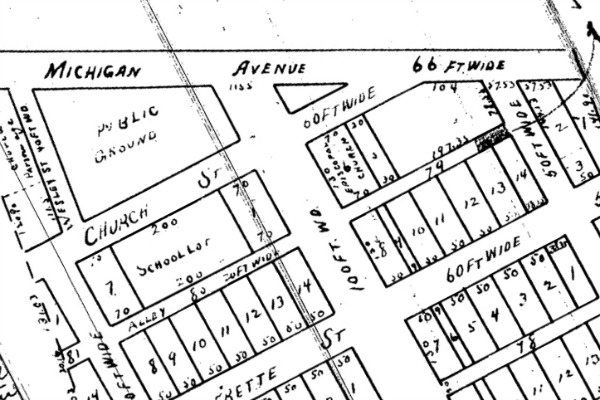
The Detroit Athletic Company block in the 1897 Sanborn map.

On August 26, 1890, building permit number 1305 was issued to the architecture firm Rogers and MacFarlane to construct a two-story brick store with an upstairs apartment at an estimated cost of $5,000. The firm was founded in 1885 by architects James S. Rogers and Walter MacFarlane. Their work includes the L. B. King & Co. Building on Library Street downtown.

A pharmacy run by William H. McFarland of the McFarland Brothers was the first commercial occupant of this space. The first store to bear the McFarland name was established by Andrew McFarland in 1880 just a few doors down at what is now 1700 Michigan Avenue. In a photograph very similar to the early 1880s near the top of this post, a painted sign for McFarland Brothers is partially visible on their first building:


Courtesy Burton Historical Collection, Detroit Public Library

An 1893 publication introducing the city to visitors describes the new McFarland Brothers location at 528 Michigan Avenue, which had opened two years before:
"Among the many pharmacies in Detroit, none is better managed than that of Mr. William McFarland, at the corner of Michigan and Harrison avenues... The store is elaborately finished in oak of modern design. The stock embraces everything in the way of drugs, fresh and pure chemicals, tinctures, elixirs, extracts, pharmaceutical, preparations of Mr. McFarland's own superior production, proprietary remedies, physicians' and surgeons' requisites, perfumery and a splendid array of toilet and fancy articles; also supplies for the sick rooms, and everything belonging to the business. The store is open at all hours of the day and night. The prescription department ... is supplied with every necessary appliance and is under the immediate supervision of Mr. McFarland."
The photograph below is not of this store, but that of William's brother James McFarland on the corner of Fort Street and Campbell in 1894. Perhaps the Michigan Avenue location had a similar look and design to this one.


Courtesy Burton Historical Collection, Detroit Public Library

William McFarland operated the store at 528 Michigan Avenue until 1896. Another of his brothers, Lewis, took charge of this location until 1913.

Subsequent occupants included:

1914-1915 John Paddock, drugs
1916-1924 James E. McEntee, drugs
1925-1929 Lynch Pharmacy (Charles V. Lynch)
1930-1932 Meriam Drug Co. (A. A. Meriam)
1933 Harrison Pharmacy (Charles A. Reed)
1935-? Mohmout Bros., groceries (Keder & Mehmet Mohmout)

The Mohmout Brothers, from Turkey, operated a grocery store here until at least 1941, but the availability of city directories after the beginning of World War II is very inconsistent, and I can't say how long for sure they were at this location.

At least as early as 1956, Garcia's Groceries had set up shop at this address. The store, owned by John Solomon of Dearborn, specialized in imported Latin American foods. It operated at least through the 1970s.


2 (2226) Harrison Avenue


Two doors face Harrison Avenue--one to an upstairs apartment and the other to a small, triangle-shaped commercial space once addressed as 2 Harrison Avenue. From 1891 until 1915, it was a plumbing shop operated by John Kenealy Jr., who lived in the apartment above. His business was evidently very successful, as he had a two-story brick house built for himself and his wife behind the shop in 1903. Like the store, it was designed by architects Rogers & MacFarlane. Kenealy lived there until at least 1940, and possibly until his death in 1949. The home was demolished around 1990.

From 1916 to 1920, the Harrison store was rented by plumbers Keiran George Costello and Frederick William Abernethy. Costello had been an employee of Kenealy's for seventeen years prior to this business venture. In 1921 just Costello was listed at this address, which by then changed to 2226 Harrison. He was followed by electricians Frank Schroeder and Edward Charles Dygert in 1922.


The Detroit Athletic Company block in the 1921 Sanborn map.

Beginning in 1923, this space became a cleaners operated by Albert and Louise Batty--in direct competition with the Star Laundry just two doors down. In fact, Mrs. Batty was the manager of the Star Laundry from 1920 to 1922. The Battys outlasted their competitor and were in operation until after Mr. Batty's death 1937.

albert_a_batty
Albert A. Batty, circa 1917.
Courtesy Burton Historical Collection, Detroit Public Library

In 1939 the Jewel Cleaners, operated by Lawrence Schwab, was at the address. It was followed by the Charles Cleaners, operated by Charles Youmans, beginning in 1940.

From 1979 to 1999, 2226 Harrison was the Corktown Social Club, founded by Ronald, Edward, and Douglas Herrick. The purpose of the organization, according to incorporation documents, was: "General pastime & drop in center for members consisting primarily of retirees, unemployed, & neighborhood residents to play games such as checkers, chess, dominos, pinochle, rummy, etc. or just plain fireside chats."

* * * * *

Today, 2226 Harrison and 1740 Michigan Avenue are used as storage and production space for the Detroit Athletic Company, whose showroom is located at 1744 Michigan Avenue. They are open to the public 10am to 5pm Monday through Saturday, and on Sundays during Tigers home games from 10am to game time.

DAC_Interior
Image Courtesy Detroit Athletic Company.

November 12, 2012

The Widening of Michigan Avenue


Buildings were demolished between 1938-1939 to allow Michigan Avenue's expansion.
Courtesy Walter Reuther Library, Wayne State University.

If you drive down Michigan Avenue often, you have probably noticed that every surviving 19th century building on it lies on the north side of the street. This is the result of a massive road-widening project that occurred in the late 1930s that entailed the condemnation of property on the avenue's south side. Half of the Victorian-era buildings on Corktown's main commercial thoroughfare were lost in this one event.


Old Chicago Road


Michigan Avenue was once so narrow that it would probably be unrecognizable to a visitor from the present day. At only 66 feet wide, it was only a little more than half of its current width of 120 feet. (That is, the full right-of-way, including sidewalks.) The sidewalk on the south side of old Michigan Avenue would have roughly coincided with today's left-hand turn lane in the middle of the road. The pre-1930s dimensions would have approximated those of 9 Mile Road in cozy downtown Ferndale.


A horse-drawn streetcar heads east on Michigan Avenue in the 1880s.
The building in the photo's center is the east half of the Detroit Athletic Co.,
which may be hard to recognize since the brick has been covered in stucco.
Courtesy Burton Historical Collection, Detroit Public Library.


Looking northeast to Trumbull and Michigan Avenue in the 1880s.
The three-story building near the center still stands at 1416-32 Michigan Ave.
Courtesy Burton Historical Collection, Detroit Public Library.

As appealing as this intimate, human-scaled urban setting would have been, Michigan Avenue was not actually intended to be this narrow.


Woodward's Plan


Detroit's main thoroughfares--Woodward, Jefferson, Gratiot, etc.--are exceptionally wide for an urban environment. This was not the result of a 20th century urban renewal project. Judge Woodward's well-known plan for Detroit (also known as the Governor and Judges' Plan) called for especially wide streets in part because the crowded conditions of the old city facilitated the rapid spread of the fire that destroyed it in 1805. Woodward wrote that "the idea of streets a hundred feet wide was a novelty which excited not only surprise but bitter indignation" among city residents. Some thoroughfares were even broader than one hundred feet: Woodward and Jefferson Avenues were 120 feet wide, and Washington and Madison Avenues spanned 200 feet. In his History of Detroit, Silas Farmer wrote, "No other city in the Union, save Washington, has so many avenues of such unusual width."

The original breadth of Michigan Avenue was supposed to be 100 feet. Beyond the city limits the avenue was called Chicago Road, built by the Federal Government to link Detroit to Fort Dearborn in Chicago. As the city expanded, the road within the annexed portions took the name of Michigan Avenue.

The road would maintain its 100-foot breadth across the first ribbon farms to be absorbed by the city's west side: the Cass, Jones, and Forsyth farms. But when it reached the border of the former Labrosse farm (between Fifth and Sixth Streets), it tapered until it reached a width of 66 feet at the border of the Baker farm (just before Brooklyn Street).


Sanborn map from 1884, showing the narrowing of Michigan
Avenue between Fifth Street and Seventh (Brooklyn) Street.

The Labrosse farm was subdivided in 1836, but at the time it was part of Springwells Township, outside the city limits. The minimum width for territorial roads was (and still is) one "chain" across, or 66 feet. This tapering of the Chicago Road appears to have been an attempt to seamlessly link broad Michigan Avenue with the narrower turnpike. The former Labrosse farm did not become part of the city until 1849, thirteen years after the original platting. By then the city presumably preferred to maintain Michigan Avenue at its reduced size rather than condemn a portion of each lot adjacent to the road. When the Woodbridge farm was subdivided in 1858, the plat map explicitly noted that Michigan Avenue would continue at 66 feet wide.


Detail from plat of Woodbridge Farm, 1858.

Calls to widen Michigan Avenue in Corktown began a least as early as 1913, when the esplanade before Michigan Central Station was still in the conceptual stage. Expanding the road between the train station and Sixth Street was estimated by the city engineer to cost $1,000,000, and the project would receive no further consideration for years.


The Super-Highway System


By the early 1920s, city streets were becoming strangled with traffic as automobiles became prevalent and large numbers of workers became concentrated in skyscrapers and factories of unprecedented size. Although streetcars were in use, the necessity of rapid transit was becoming self-evident.

The Detroit Rapid Transit Commission was formed in 1922 to study this problem. After more than a year research, it unveiled its solution: the "Super-Highway System"--a comprehensive plan integrating both automobiles and light rail in the same rights-of-way. In a report dated April 10, 1924, the Commission called the System a "joint transit facility serving both rapid transit on rails and express motor traffic on rubber tires. ... Both services are essential to the welfare of the present communities and the future city. ... both (are) essential to make the land accessible, useful and valuable."

The plan included subways beneath the city's arterial roads. On the surface, these roads would accommodate eight lanes of automobile traffic--four inner "express" lanes and four outer "local" lanes. The inner lanes resembled modern expressways in that opposing traffic was separated by safety barriers, the lanes crossed over intersecting roads at half-mile intervals, and traffic signals were eliminated. This concept was practically a new invention. The first controlled-access dual highway ever built (Italy's Autostrada) had not yet opened. In the undeveloped suburbs, where land was cheaper, the subway trains would run at grade between opposing lanes of traffic, as pictured below.


An illustration of the subway's transition to surface trains in suburban areas.
Detroit Rapid Transit Commission, The Relation of Individual to Collective Transportation (Detroit: Heitman-Garand Co., 1928)

The plan called for Michigan Avenue and Detroit's other radial streets to be widened to a uniform 120 feet for two reasons: First, it was the minimum practical space to accommodate the automobile lanes, 15-foot sidewalks and various safety separations; and second, it was the width required to build local and express subway lines between building foundations while leaving enough room for sewers and other utilities.


Detroit Rapid Transit Commission, Report of the Street Railway Commission and the Rapid Transit Commission to Hon. John C. Lodge, Mayor, and the Honorable the Common Houncil on a Rapid Transit System for the City of Detroit (Detroit, 1929)

The Commission did not believe that a width of 120 feet was a radical concept. In a report to City Council, they only claimed to be "readopting the 120 feet of the 118 year old Governor and Judges Plan". They praised the "vision" and "courage" of the 1805 plan and derided the "encroachment" they felt was responsible for narrowing certain roads.

The Super-Highway System was intended to be built in stages as the city grew. The long-term plan included a subway beneath Michigan Avenue that would run from Campus Martius to Michigan Central Station with stops at Second Street, Trumbull, and Vermont in between. From Michigan Central, it would continue underground along Vernor toward Ford's River Rouge plant.


Detail from a map of the proposed Rapid Transit System drawn in 1929.
Courtesy Burton Historical Collection, Detroit Public Library

The city wasn't exactly on the verge of building this system. Obtaining the appropriate rights-of-way was merely the first step of a long process, and road-widening projects were seen as an economic way to postpone subway construction that was estimated to cost over $5 million per mile.

The Rapid Transit and City Plan Commissions created a Master Plan for the city which City Council approved on April 14, 1925. On September 1st, the Council ordered a referendum on the widening Michigan Avenue to 120 feet between Fifth Street and Livernois to appear on the primary election ballot that fall. (By that point, Michigan Avenue was already being widened west of Livernois.) On October 6, 1925, the proposal passed by a wide margin, with 74,397 votes in favor and 32,767 against. One week later the City Council ordered the City Plan Commission to produce a detailed plan for the project.


Looking northeast toward Michigan Avenue and Trumbull in 1917, before widening.
Courtesy Burton Historical Collection, Detroit Public Library.


Debates and Delays


Despite the mandate from the voters, little action was taken over the next several years. The City Plan Commission eventually submitted their plan in 1927, only to have the City Council change its mind and decide to widen Michigan Avenue to only 100 feet between Fifth and Livernois. Indecision over the details of the plan postponed any action for years.

Finally, in July of 1930, the State of Michigan offered to cover half the costs of the project as long as Michigan Avenue was widened to the full 120 feet as outlined in the Master Plan. After still further debates (including which side of the road should be condemned), the City Council voted on October 14, 1930 to adopt the 120-foot plan and to condemn the south side of the avenue in Corktown.


Looking west on Michigan Avenue toward Sixth Street before widening, c. 1930s.
The building marked by the red arrow now houses PJ's Lager House.
Courtesy Walter Reuther Library, Wayne State University.

It took years to resolve the condemnation suits brought by the city. The project was implemented in segments, with Corktown being last. The condemnation suit affecting the area between Fifth and Fourteenth Streets began January 1, 1937 in Recorder's Court with Judge Edward J. Jeffries Sr. presiding. On June 23, 1937, a jury awarded $601,243.95 to the owners of the 68 condemned parcels of land.


Demolition


The wrecking of buildings began in 1938. The City Plan Commission's annual report for 1939 noted that the demolition was "practically completed". The repaving of the road occurred in 1940.


Above: This handsome row of commercial buildings once lined the south side of Michigan Avenue west of Sixth Street. (Courtesy Walter Reuther Library, Wayne State University.)
Below: Barren pavement has replaced dense urban fabric. The block never recovered.


Looking east down Michigan Avenue near Eighth Street.


Above: The Detroit Police's second precinct station house was built on a triangle of land bounded by Michigan, Trumbull, and Church Street between 1899 and 1900. Designed by architects William S. Joy and Frederick T. Barcroft, it replaced an earlier precinct house built on this spot in 1873. (Courtesy Burton Historical Collection, Detroit Public Library.)
Below: Workers demolish the building in preparation of the road widening. A portion of the triangle of land remains in the middle of Trumbull today. (Courtesy Walter Reuther Library, Wayne State University.)


Above: Looking east down Michigan Avenue from the top of the CPA Building, c. 1930s.
(Courtesy Walter Reuther Library, Wayne State University.)
Below: The building on the lower-left is reportedly a barbecue theme restaurant.
(Photo by Flickr user nitram242. Click on the image to see the original.)

slows-from-cpa


Survivors


Just a handful of large industrial buildings escaped complete destruction, but none date to the 19th century.


1907 and 1927 Michigan Avenue.

Both buildings pictured above were constructed in 1907, both were designed by architect Richard E. Raseman, and both were originally hosiery factories. The building on the left was the headquarters of Chicago Hosiery, which moved to Detroit from its namesake city in 1898. Three months after construction started on this factory, work began on its companion, the Detroit-Alaska Knitting Mills. When the second structure was being built, the Free Press reported on July 14, 1907: "The factory is located in this district because of the fact that it has become known as a good location in which to secure labor of the class needed in light factory work."


The former Chicago Hosiery and Detroit-Alaska Knitting Mills in 1921 and
in 1950, after the front fifty-four feet of each building had been removed.

Another survivor is the building that has housed Eaton Spring Manufacturing since 1939. It was originally built around 1927 as a garage for the cartage company Charles J. Burnham & Son.


1555 Michigan Avenue, at the corner of Tenth Street.

The only other building on the south side of the street that predates 1940 is a nondescript, single-story brick building at 1375 Michigan Avenue, at the corner of Eighth Street. It was another garage, built around 1920 for the Baker-Fisk-Hugill Company, distributors of the Dort Motor Car.


* * * * *

"American downtowns are not declining mysteriously, because they are anachronisms, nor because their users have been drained away by automobiles. They are (being) witlessly murdered..."
--Jane Jacobs,
The Death and Life of Great American Cities, 1961

The extensive widening of surface streets was already considered obsolete by the time the Michigan Avenue project was completed. The City Plan Commission reported in 1946, "it was observed that the increased number of traffic lanes made possible by street-widenings intensified congestion at intersections." Further condemnations for road widening projects had already been banned by 1938, and limited-access expressways were considered the way of the future. Large swaths of Corktown would later be destroyed to make way for the Lodge and Fisher Freeways.

The south side of Michigan Avenue never fully recovered from the destruction of seventy years ago, while most of the new and interesting commercial activity occurring here today is staged in the surviving Victorian buildings on the north side of the street. Although streetcars ran down the avenue until the mid-1950s, the long hoped-for rapid transit system never materialized. Now that expressways carry most traffic, Michigan Avenue's nine lanes are highly underutilized. The 1950 Sanborn map shows very little new construction on the south side of the road even a full decade after the widening. Most of the buildings on that map are single-story, cinder-block structures, including gas stations, auto repair shops, parking lots, a tire store, a car wash, and a few restaurants. Although the uses of some of these buildings have shuffled, these exact services still account for most of what one finds on the south side of Michigan Avenue decades later.

I would like to leave you today with the following video clip: